Loch Lochy
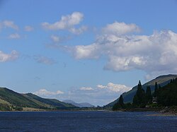
Nestled in the heart of Lochaber within the Highland region of Scotland, Loch Lochy (Scottish Gaelic: Loch Lòchaidh) is a striking freshwater loch known for its impressive depth and serene beauty. As a key feature of the Scottish landscape, it serves as both a geographical landmark and a site of deep historical significance.
The loch is particularly notable for its bathymetry—the study of underwater depth—ranking as the fourth-deepest loch in Scotland. Its clear waters and dramatic surroundings make it a point of interest for those traveling through the rugged terrain of the Highlands.
Key Facts
- Location: Lochaber, Highland, Scotland.
- Depth: Fourth-deepest loch in Scotland, reaching a maximum of 162 meters.
- Connectivity: Linked to Loch Oich via the Caledonian Canal.
- Water Flow: Fed by the River Arkaig and drained by the River Lochy.
- Dimensions: Approximately 16 km in length with a surface area of 16 sq km.
Geography and Hydrology
Loch Lochy is situated along the Great Glen, a major geological fault line that cuts across the Scottish Highlands. It lies approximately 16 km southwest of the world-famous Loch Ness. The loch stretches over 15 km in length and maintains an average width of about 1 km.
The hydrology of the loch is defined by its primary inflows and outflows. The River Arkaig feeds into the loch, while the River Lochy flows out from its southwestern end. To the northeast, the Caledonian Canal—a man-made waterway—connects Loch Lochy to Loch Oich, facilitating navigation through the Highlands.
| Feature | Measurement |
|---|---|
| Maximum Length | 16 km (9.9 mi) |
| Surface Area | 16 km² (6.2 sq mi) |
| Average Depth | 70 m (230 ft) |
| Maximum Depth | 162 m (531 ft) |
| Water Volume | 1.1 km³ (0.26 cu mi) |
| Surface Elevation | 29 m (94 ft) |
History and Conflict
The lands surrounding Loch Lochy have been the stage for significant clan conflicts. In July 1544, the northern end of the loch near Laggan was the site of the Battle of the Shirts, a violent clash between Clan Donald and Clan Fraser.
Later, in September 1665, the isthmus between Loch Lochy and Loch Arkaig at Achnacarry hosted the Stand-off at the Fords of Arkaig. This event was pivotal in Scottish history as it brought an end to a 360-year-long feud between the Camerons and the Chattan Confederation.
Folklore and Legends
Beyond its history of warfare, Loch Lochy is steeped in local mythology. Folklore speaks of the River Horse, a supernatural entity also referred to as the Water King or the Lord of the Lake. Legend claims this creature would emerge from the depths in the shape of a horse to feed on the banks, overturn boats, and entice mares away from their pastures.
In contrast to the mischievous River Horse, traditions also mention the River Bull. Described as a gentle and harmless creature, the River Bull was said to emerge from the loch to visit the pastures of cows.
Frequently Asked Questions
How deep is Loch Lochy?
Loch Lochy has an average depth of 70 meters (230 ft) and reaches a maximum depth of 162 meters (531 ft), making it the fourth-deepest loch in Scotland.
Where is Loch Lochy located?
It is located in Lochaber, Highland, Scotland, situated along the Great Glen approximately 16 km southwest of Loch Ness.
What is the difference between Loch Lochy and Loch Loch?
Loch Lochy is the large freshwater loch in Lochaber, whereas Loch Loch is a separate body of water located to the east of Beinn a' Ghlò.
Which rivers are associated with Loch Lochy?
The primary inflow is the River Arkaig, and the primary outflow is the River Lochy.
What historical battles took place near the loch?
The Battle of the Shirts (1544) occurred at its northern end, and the Stand-off at the Fords of Arkaig (1665) took place on the isthmus between Loch Lochy and Loch Arkaig.