Jan Mayen: A History of Arctic Exploration, Whaling, and Strategic Conflict
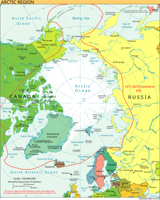
Located in the remote reaches of the Arctic Ocean, Jan Mayen is a volcanic island with a history defined by isolation, industrial ambition, and strategic military importance. From early Viking whispers to its role as a Cold War listening post, the island has served as a waypoint for those braving the harshest conditions on Earth.
Early Mysteries and Unverified Discoveries
The origins of Jan Mayen's discovery are shrouded in uncertainty. The early medieval book Landnámabók mentions a land called Svalbarð ("cold coast"). While modern historians often associate this with Spitsbergen, the sailing distance described—two days from Iceland—aligns more closely with the 550 km (340 mi) journey to Jan Mayen than the 1,550 km (960 mi) to Spitsbergen.
By the 17th century, the rivalry of Arctic whaling sparked numerous claims of rediscovery. Some sources attributed the discovery to William Hudson in 1608, while others claimed Hull whalers found it around 1611, naming it "Trinity Island." However, these claims lack cartographical or written evidence.
The Golden Age of Dutch Exploration
The first verified discoveries occurred in the summer of 1614 through three separate expeditions. Fopp Gerritsz, leading an expedition for Englishman John Clarke, claimed to have found the island on June 28, naming it "Isabella." Simultaneously, the Noordsche Compagnie (Northern Company)—a Dutch whaling organization modeled after the East India Company—sent ships that reached the island in July 1614.
Captains Jan Jacobszoon May van Schellinkhout and Jacob de Gouwenaer named the land Mr. Joris Eylant after the cartographer Joris Carolus. Another ship, the Cleyn Swaentgen, had arrived even earlier, naming it Maurits Eylandt. The discovery remained a point of contention among Dutch merchants until 1617.
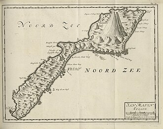
The island's modern name was solidified by the Amsterdam cartographer Willem Jansz Blaeu. In his 1620 map of Europe and his 1623 Zeespiegel atlas, he named the island "Jan Mayen" after Captain Jan Jacobszoon May van Schellinkhout.
The Rise and Fall of the Whaling Industry
Between 1615 and 1638, Jan Mayen served as a primary base for the Noordsche Compagnie, which held a Dutch monopoly on Arctic whaling. The industry grew rapidly; by 1616, twenty vessels visited the island, including ships from London and Hull.
Initially, whalers lived in temporary sail tents with crude furnaces. By 1624, the infrastructure evolved into semi-permanent stations in South Bay and North Bay, featuring wooden storehouses and large brick furnaces. To protect these assets, two forts were constructed in 1628. Notably, the future admiral Michiel Adriaensz de Ruyter served as an officer here in the 1630s.
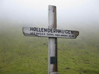
The industry was not without tragedy. In the winter of 1633/34, a seven-man crew tasked with defending the island against Basque plunders perished from a combination of scurvy, trichinosis (caused by eating raw polar bear meat), and extreme weather.
The economic viability of the island collapsed as the bowhead whale was hunted to near-extinction. By 1640, approximately 1,000 whales had been processed, and the island was abandoned for the next 250 years.
Modern Expeditions and Norwegian Sovereignty
Interest returned during the International Polar Year (1882–1883), when the Austro-Hungarian North Pole Expedition, funded by Count Wilczek, conducted extensive mapping that remained the standard until the 1950s. In the early 20th century, Norwegian trappers hunted Arctic foxes and polar bears, though this eventually became unprofitable.
The League of Nations granted Norway jurisdiction over the island, leading to the establishment of a meteorological station in 1921. Norway annexed the middle of the island in 1922 and the entire territory by 1926, officially making Jan Mayen part of the Kingdom of Norway on February 27, 1930.
Strategic Importance in World War II
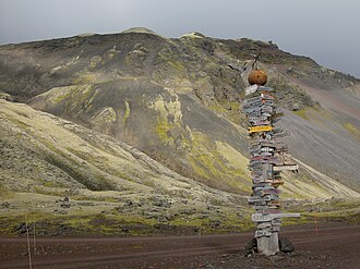
During the German occupation of Norway in 1940, the four-man team on Jan Mayen defied the Axis powers by sending weather reports to the United Kingdom. The British codenamed the location "Island X." In November 1940, the Norwegian patrol boat HNoMS Fridtjof Nansen ran aground on lava reefs, forcing its 68-man crew to join the shore team.
The British eventually evacuated the island and demolished the weather station to prevent German capture. A subsequent German attempt to land a weather team on November 16, 1940, failed when their trawler crashed after being detected by British radar and wireless interceptors.
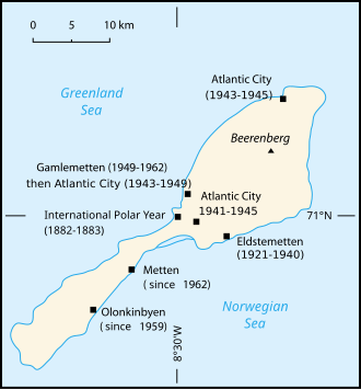
The Allies returned in March 1941, establishing a garrison of weathermen and soldiers. Despite frequent German bombing and strafing raids, the Allies maintained control. In 1943, the United States added a radio locating station called "Atlantic City" to track German radio bases in Greenland.
The Cold War and Geological Activity
Post-war Jan Mayen became a critical node for Arctic ship traffic and military communications. In 1959, NATO integrated the island into the LORAN-C (Long Range Navigation) network, constructing a transmitter and a new airfield by 1961.
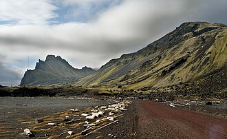
The island is dominated by the Beerenberg volcano. Once thought dormant, it erupted in 1970, 1973, and 1985. The 1970 eruption added 3 square kilometers of land and caused local sea temperatures to spike from near-freezing to 30 °C (86 °F).
A brief territorial dispute between Iceland and Norway from 1979 to 1980 was resolved when Iceland recognized Norwegian sovereignty.
| Period | Primary Activity | Key Entity/Event |
|---|---|---|
| 1614–1640 | Commercial Whaling | Noordsche Compagnie |
| 1882–1883 | Scientific Mapping | Austro-Hungarian Expedition |
| 1921–1930 | Annexation | Kingdom of Norway |
| 1940–1945 | Military Intelligence | WWII "Island X" |
| 1959–Present | Strategic Navigation | NATO LORAN-C / Meteorology |
Key Facts
- First Verified Discovery: Occurred in 1614 by three separate Dutch expeditions.
- Naming: Named by cartographer Willem Jansz Blaeu after Captain Jan Jacobszoon May van Schellinkhout.
- Industrial Peak: The Noordsche Compagnie operated whaling stations until the bowhead whale was nearly extinct by 1640.
- WWII Role: Served as a secret weather and radio outpost for the Allies, codenamed "Island X."
- Geology: Home to the Beerenberg volcano, which last erupted in 1985.
- Sovereignty: Officially became part of Norway in 1930.
Frequently Asked Questions
Who officially discovered Jan Mayen?
While several claims exist, the first verified discoveries happened in 1614. Three Dutch expeditions reached the island, including those led by Fopp Gerritsz and captains from the Noordsche Compagnie.
Why was the island abandoned in the 17th century?
The island was abandoned around 1640 because the local population of bowhead whales had been hunted to near-extinction, making the whaling stations economically unviable.
What was the significance of "Island X"?
"Island X" was the British codename for Jan Mayen during World War II. It was a strategic location for weather reporting and radio intelligence to counter German movements in the Arctic.
Is the Beerenberg volcano still active?
Yes, the Beerenberg volcano is active. It had notable eruptions in 1970, 1973, and 1985, with the 1970 event actually increasing the island's total land area.
How did Norway acquire the island?
Norway established a meteorological station in 1921 and gradually annexed the territory between 1922 and 1926. It became de jure part of the Kingdom of Norway in 1930.