Illinois Country: French Exploration and Settlement in North America
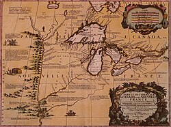
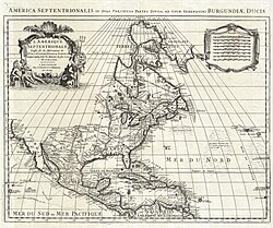
The Illinois Country served as a strategic frontier for France in North America, bridging the gap between Canada and the Gulf of Mexico. From the early 17th century through the late 18th century, this region was a hub of missionary work, fur trading, and military fortification, shaping the cultural and political landscape of the Mississippi River basin.
Early French incursions began in the first half of the 1600s. Étienne Brûlé explored the upper regions in 1615, and by 1627, Joseph de La Roche Daillon had reached the northeastern fringes of the Mississippi River basin. However, the region's significance grew substantially in 1673–74 when Father Jacques Marquette and Louis Jolliet explored the territory from Green Bay to the Arkansas River, documenting the Illinois River valley.
Key Facts
- Primary Settlements: Kaskaskia, Cahokia, and Sainte Genevieve were the central hubs of French presence.
- Strategic Forts: Fort St. Louis du Rocher and Fort de Chartres served as critical military and administrative centers.
- Population Growth: By 1752, the non-native population had reached 2,573 inhabitants.
- Economic Drivers: The region relied heavily on the fur trade and communal agriculture.
- Demographics: By the mid-18th century, enslaved Africans constituted as much as one-third of the population.
Fort St. Louis du Rocher
Established in the winter of 1682 by René-Robert Cavelier, Sieur de La Salle, Fort St. Louis was built atop a large butte known as Le Rocher. This elevation provided a tactical advantage over the Illinois River. The fort consisted of a wooden palisade, wooden houses, and native shelters, intended to block English expansion from the East Coast.
The fort served as a refuge during the early French and Indian Wars against the British-allied Iroquois. However, the Iroquois forced the settlers, led by Henri de Tonti, to abandon the site in 1691. Tonti subsequently reorganized the settlers at Fort Pimitoui in present-day Peoria.
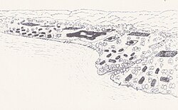
The site is also the subject of local legend. After an attack by the Ottawa and Potawatomi tribes, a group of Illini sought refuge on the butte but were eventually starved into submission. Consequently, Europeans renamed the landmark Starved Rock.
Fort de Chartres and Administrative Control
In 1718, John Law's Company was granted a trade monopoly and established Fort de Chartres to protect mining interests. The first fort was completed in 1720 on the east bank of the Mississippi River. Due to frequent flooding, a second location was built further inland in 1725.
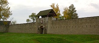
A permanent stone fort was constructed between 1754 and 1760, serving as the headquarters for the French Illinois Country. Following the Treaty of Paris in 1763, the fort was ceded to the British. Under British rule, it was renamed Fort Cavendish in 1765. The British established the first court of common law in the Mississippi Valley here in 1768, replacing the French civil law system.
Agricultural Settlement and Social Structure
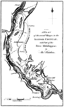
The French in the Illinois Country adopted a unique settlement pattern. Unlike the typical "ribbon plots" (long rectangular plots stretching from a river) found elsewhere in French North America, these settlers lived in concentrated farming villages and practiced communal agriculture, mirroring the village structures of northern France.
Labor in the region evolved significantly after the founding of New Orleans in 1718. African slaves were imported for mining and agricultural work. In 1720, Philip Francois Renault arrived with 500 enslaved people from Saint-Domingue to work coal and lead mines. Although the mines proved unprofitable, Renault established the village of St. Philippe in 1723, which became a successful agricultural producer.
Major Settlements and Missions
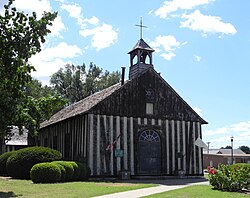
- Cahokia: Founded in 1696, it became one of the most populous northern towns and later the seat of St. Clair County.
- Kaskaskia: Established in 1703, it served as the capital of the Illinois Territory (1809–1818) and the first capital of the state of Illinois.
- Sainte Genevieve: Founded around 1750, this village is noted for retaining the most French Colonial architecture in the United States.
- Peoria: Home to Fort Crevecoeur (1680) and Fort Pimiteoui (1691), it remained a French stronghold for over a century.
| Settlement | Established | Primary Significance |
|---|---|---|
| Cahokia | 1696 | Populous hub and later county seat |
| Kaskaskia | 1703 | First capital of the state of Illinois |
| Fort de Chartres | 1718 | Administrative seat and military stronghold |
| Sainte Genevieve | c. 1750 | Center of French Colonial architecture |
| St. Louis | 1764 | Capital of Upper Louisiana |
Frequently Asked Questions
What was the primary purpose of Fort St. Louis du Rocher?
It was designed as a defensive fortification to protect French interests against English incursions and to keep English settlements confined to the East Coast.
How did the settlement pattern in the Illinois Country differ from other French colonies?
While other colonies used separated ribbon plots, settlers in the Illinois Country lived together in communal farming villages similar to those in northern France.
What happened to Fort de Chartres after the French and Indian War?
It was turned over to the British in 1763 via the Treaty of Paris, renamed Fort Cavendish, and eventually abandoned by the British in 1772 following severe flooding.
Who was Chief Pontiac and what happened to him in Cahokia?
Chief Pontiac was a prominent Native American leader who was assassinated on April 20, 1769, by an Illinois Confederation warrior while on a diplomatic mission in Cahokia.
What is the significance of Kaskaskia in Illinois history?
Kaskaskia served as the capital of the Illinois Territory from 1809 to 1818 and was the first capital of the state of Illinois from 1818 to 1820.