Fort Augustus: A Historic Gateway to Loch Ness
Nestled at the south-west end of Loch Ness in the Scottish Highlands, Fort Augustus is a picturesque settlement known for its deep historical roots and stunning natural surroundings. With a population of approximately 620 as of 2020, this village serves as a vital hub for tourism, blending military history, monastic heritage, and the engineering marvels of the Caledonian Canal.
Key Facts
- Location: South-west end of Loch Ness, Highland council area, Scotland.
- Gaelic Name: Cille Chuimein.
- Primary Economy: Heavily reliant on tourism.
- Key Landmark: The Caledonian Canal locks.
- Climate: Oceanic (Cfb), characterized by cool summers and mild winters.
The History of Fort Augustus
Early Origins and Etymology
Before it was known as Fort Augustus, the settlement was called Kiliwhimin until the early 18th century. The Gaelic name, Cille Chuimein, is widely believed to honor Saint Cummein of Iona, who established a church in the area. Alternative theories suggest the name may refer to the Comyn clan or serve as a burial place for the last Comyn in Lochaber.
The area's ancient history is further highlighted by a hoard of Roman coins discovered in 1767 near an ancient Benedictine abbey. These coins, dating from 79 AD to 560 AD, led some historians, including Sir George Macdonald, to suggest that the site may have once housed a small Roman fortification built under the rule of Emperor Diocletian.
Military Significance and the Jacobite Risings
The modern identity of the village was forged following the Jacobite rising of 1715. Between 1729 and 1742, General Wade constructed a fort named after Prince William Augustus, Duke of Cumberland. Wade originally envisioned a town called Wadesburgh surrounding the barracks, and the growing settlement eventually adopted the name of the fort.
The fort became a flashpoint during the Jacobite rising of 1745. In December 1745, 600 men from the Independent Highland Companies—units formed to support the British-Hanoverian government—liberated the fort from the Jacobite Clan Fraser of Lovat. However, the government garrison eventually surrendered after a Jacobite siege between February 22 and March 1, 1746.
From Monastic Life to Heritage
In 1867, the fort was sold to the Lovat family, who later transferred the land to the Benedictine order in 1876. The monks established Fort Augustus Abbey and a school, the latter of which operated until 1993. In an attempt to preserve the site, it was converted into Scotland's largest private heritage centre between 1994 and 1998. When the centre proved unprofitable, the site reverted to the Lovat family and was subsequently sold to Terry Nutkins.
Today, the Lovat Hotel stands on the site of the old Kilwhimen Barracks. This location preserves the west curtain wall of the original fort, complete with its historic gun embrasures.
Infrastructure and Transport
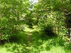
Fort Augustus is strategically located on the A82 road, roughly midway between Inverness (35 mi / 56 km) and Fort William (32 mi / 51 km). While the village was once served by a rail line from Spean Bridge (operating from 1903 to 1933), it now relies on road and bus transport provided by operators such as Ember, Scottish Citylink, West Coast Motors, and the Highland Council.
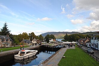
One of the village's most defining features is the Caledonian Canal. This waterway connects Fort William to Inverness and passes through Fort Augustus via a dramatic series of locks that step down into Loch Ness.
Local residents are served by the Cill Chuimein Medical Centre and a shared educational campus featuring Kilchuimen Primary School and Kilchuimen Academy.
Climate and Geography
The village experiences an oceanic climate (Köppen: Cfb). Due to its valley location, Fort Augustus can act as a frost trap on clear, calm nights; it holds the UK's joint lowest May temperature record of −9.4 °C (15.1 °F). Conversely, its topography can occasionally produce high temperatures, including a long-standing record for December 16.
The area receives significant precipitation, averaging over 1,300 mm annually, with sunshine levels averaging around 1,005 hours per year.
| Metric | Coldest Month (Jan) | Warmest Month (Jul) | Annual Average/Total |
|---|---|---|---|
| Mean Daily Max Temp | 6.3 °C (43.3 °F) | 18.6 °C (65.5 °F) | 12.2 °C (54.0 °F) |
| Mean Daily Min Temp | 1.0 °C (33.8 °F) | 10.9 °C (51.1 °F) | 5.2 °C (41.4 °F) |
| Average Precipitation | 190.6 mm | 71.3 mm | 1,359.4 mm |
| Sunshine Hours | 26.2 hrs | 115.4 hrs | 1,005 hrs |
Notable Figures
- Guy Prendergast (1905–1986): An explorer and soldier buried in Strathoich cemetery.
- Alexander Fraser (1789–1872): A soldier and hero of the 1813 Battle of Stoney Creek during the War of 1812, noted for capturing two American commanding generals.
Frequently Asked Questions
What is the significance of the locks in Fort Augustus?
The locks are part of the Caledonian Canal, providing a dramatic engineering sequence that allows vessels to transition in elevation as the canal steps down into Loch Ness.
Why was the fort originally built?
General Wade built the fort between 1729 and 1742 following the Jacobite rising of 1715 to establish a government presence in the Highlands.
What happened to the Fort Augustus Abbey school?
The school closed in 1993 due to declining enrollment caused by changing educational patterns across Scotland.
Is there any evidence of Roman presence in the village?
Yes, a hoard of Roman coins dating from 79 AD to 560 AD was found in 1767, leading to theories that a small Roman fortification may have existed there under Emperor Diocletian.
What is the weather typically like in Fort Augustus?
The village has an oceanic climate with mild winters and cool summers. It is known for unpredictable temperatures and can be particularly cold in May due to its valley topography.