Fluvial Terraces: The Geological Record of River Evolution
Across the globe, the landscapes flanking river valleys often feature elongated, step-like landforms known as fluvial terraces. These features are more than just scenic benches; they are remnants of ancient floodplains that provide a chronological record of a river's history. By analyzing these terraces, geologists can reconstruct past climates, tectonic shifts, and the evolving power of water to shape the Earth's crust.
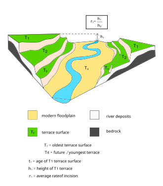
A fluvial terrace consists of a relatively level strip of land called a tread, which is separated from the current floodplain, other terraces, or higher uplands by steeper slopes known as risers. These structures lie parallel to and above the active river channel. Because they form through alternating cycles of deposition and erosion, they are underlain by fluvial sediments—materials transported and deposited by water—of highly variable thickness.
Essentially, a terrace is an abandoned floodplain. It forms when a river, which once flowed at a higher elevation, cuts downward (incises) to create a new, lower floodplain. This shift in elevation is often driven by changes in the base level—the lowest point in a fluvial system—which triggers headward erosion, lowering the river's elevation over time.
Key Facts
- Formation: Terraces are created when a river incises into its own previous floodplain.
- Treads and Risers: The flat top is the tread; the steep slope is the riser.
- Primary Types: Fill terraces (depositional) and strath terraces (erosional).
- Drivers: Tectonic uplift and climate change are the primary mechanisms causing terrace development.
- Dating: Techniques like radiocarbon and cosmogenic nuclides help determine the age of terrace surfaces.
Types of Fluvial Terraces
Geologists categorize terraces based on how they were formed and their relative positions within the valley.
Fill Terraces
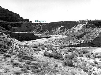
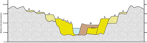
Fill terraces occur when a valley is filled with alluvium (river-deposited sediment). This happens when there is an influx of bed load—often due to glaciation or changes in stream power—causing the river to deposit material until an equilibrium is reached. When conditions change and the river begins to incise into this deposited material, benches of alluvium are left on the valley sides. The highest of these benches is the fill terrace.
Cut and Nested Fill Terraces
As a river continues to cut through alluvium, it may create multiple levels of terraces. Those located below the primary fill terrace are called cut terraces (or cut-in-fill terraces), which are erosional in origin. In some cases, a valley may fill with alluvium, be incised, and then fill again to a lower level. These are known as nested fill terraces and can often be identified by a sudden change in sediment characteristics, such as a shift to finer materials.
Strath Terraces
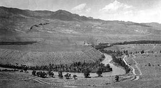
Unlike fill terraces, strath terraces result from a river cutting directly into bedrock. During periods of equilibrium—caused by paused tectonic uplift, climate shifts, or changes in bedrock type—the river widens its valley floor. When the river eventually resumes its downward cutting, the flattened bedrock floor (sometimes covered by a thin layer of alluvium) is left high above the current channel.
Paired vs. Unpaired Terraces
Terraces are described as paired when they exist at the same elevation on opposite sides of the river, typically resulting from river rejuvenation where the river cuts evenly on both sides. Unpaired terraces occur when the river encounters erosion-resistant material on one side, leaving a terrace on only one bank.
The Mechanics of Formation
The development of terraces is a tug-of-war between aggradation (the buildup of sediment) and incision (the cutting away of sediment or rock). This balance is influenced by the stream gradient, the volume of water, and the amount of sediment being transported.
By measuring the height of a terrace from the current river level (h) and determining the age of the surface (t), scientists can calculate the average rate of incision (r = h/t). To determine the age of the treads, geologists use various geochronologic techniques, including:
- Radiocarbon dating and Thermoluminescence.
- Cosmogenic nuclides and U-Th disequilibria.
- Magnetostratigraphy and Low temperature thermochronology.
- Biostratigraphy (using preserved fossil successions).
Climate and Tectonic Drivers
Large-scale terrace patterns usually indicate regional geologic or environmental forces. The scale of observation is critical: long time scales (over 10^6 years) typically reveal tectonic processes, while shorter scales (10^1 to 10^5 years) often reflect climatic cycles.
Climatic Influence
In stable interior regions, terraces often record the Milankovitch cycles—periodic variations in Earth's orbit and rotation. These cycles drive the shift between glacial and interglacial periods, alternating between phases of sediment accumulation and river incision.
![The Rio Grande, flowing down through the Rio Grande Rift for the last several million years. The last stage of incision by the river is thought to be driven by the Milankovitch eccentricity cycle. Increased precipitation and sediment supply drove incision of the high standing terraces, beginning at ~800ka.[12]](/images/b5/de/b5de5856d9daf975e1d154179de831b62302f78c726fe748e9c937a8203bb146.jpg)
Tectonic Uplift
Tectonic activity can increase the slope of a river, boosting its flow rate and erosive power. This forces the river to abandon its floodplain and cut downward. Episodic uplift creates a series of terraces, while prolonged uplift often leads to the formation of strath terraces as the river cuts into bedrock.
Tectonic-Climatic Interactions
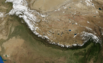
Tectonics and climate often operate in a positive feedback loop. A prime example is the Himalayan front. The mountains act as an orographic barrier, creating a rain shadow effect where moisture is released on one side (fueling the Asian monsoon) and dry air descends on the other. The resulting heavy precipitation on the southern slopes accelerates erosion. As sediment is stripped away, the crust's buoyancy (isostasy) triggers further tectonic uplift, which in turn creates higher topography and more precipitation.
| Terrace Type | Primary Process | Composition | Origin |
|---|---|---|---|
| Fill Terrace | Aggradation followed by Incision | Alluvium | Depositional |
| Cut Terrace | Continued Incision | Alluvium | Erosional |
| Nested Fill | Cyclic Filling and Incision | Alluvium (often finer) | Depositional |
| Strath Terrace | Bedrock Downcutting | Bedrock (thin alluvium) | Erosional |
Frequently Asked Questions
What is the difference between a tread and a riser?
The tread is the relatively flat, level surface of the terrace (the former floodplain), while the riser is the steeper slope that connects the tread to the next terrace level or the current valley floor.
How do paired terraces form?
Paired terraces form when a river undergoes rejuvenation and cuts downward evenly into its valley floor on both sides, leaving matching terrace levels on opposite banks.
What causes a river to switch from depositing sediment to cutting into it?
This shift is usually caused by a disturbance in the river's equilibrium, such as a drop in base level, tectonic uplift increasing the slope, or climatic changes that alter water volume and sediment supply.
What is the rain shadow effect in the context of terraces?
The rain shadow effect occurs when mountains block moisture-bearing air, causing heavy rain on the windward side and arid conditions on the leeward side. This concentrated precipitation increases erosion on one side of the range, driving the rapid incision and terrace formation seen in regions like the Himalayas.
How can scientists tell if a terrace was caused by climate or tectonics?
Scientists look at the scale and distribution. Regional terraces of the same age often suggest large-scale tectonic uplift, while periodic, cyclic terraces in tectonically quiet areas often correlate with global climatic cycles like the Milankovitch cycles.