Ensenada de Barragán: History and Legacy of a Strategic River Plate Bay
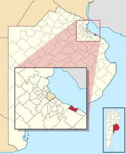
Located approximately 40 kilometres (25 mi) southeast of Buenos Aires, Argentina, the Ensenada de Barragán (Barragán's Bay or Cove) is a small bay on the Río de la Plata. Situated within the Ensenada district of the Buenos Aires province and centered around the city of Ensenada, this coastal area has evolved from a vital natural harbor into a modern industrial gateway. Over centuries, the bay has undergone significant geographical changes, partly silting up since the 17th century, which has led the area to be considered part of Isla Santiago (Santiago Island).
Key Facts
- Location: Ensenada district, Buenos Aires province, Argentina.
- Naming: Named after Antonio Gutiérrez Barragán, who purchased the land in 1629.
- Strategic Role: Served as a natural port and defensive stronghold (Fuerte Barragán) until the mid-19th century.
- Modern Use: Now part of the industrial Port of La Plata.
- Cultural Site: Fuerte Barragán currently operates as a Historic Museum.
From Early Mapping to Colonial Settlement
The coastal region of the Ensenada de Barragán was first mapped in 1520 by Ferdinand Magellan during his historic circumnavigation of the globe. Settlement of the bay began in the early 17th century under the direction of Hernandarias. The area's current name is derived from its 1629 ownership by Antonio Gutiérrez Barragán. While the land was settled early, the formal town of Ensenada was not founded until 1801.
The Strategic Importance of Fuerte Barragán
Until the mid-1800s, the bay was prized as a high-quality natural port. To protect this asset, Spanish governors and the Viceroys of the River Plate established a series of defenses, including a defensive wall and artillery batteries. This fortification became known as Fuerte Barragán (Fort Barragán).
Founding and Early Defense
On January 2, 1801, Viceroy Marqués de Avilés granted Colonel Pedro Cerviño the authority to settle a town at the bay. Cerviño was tasked with the construction of the fort's first defensive wall and an eight-cannon battery to secure the coastline.
Role in the British Invasions
Fuerte Barragán played a pivotal role during the British invasions of the Rio de la Plata. In June 1806, under the command of Santiago de Liniers, the fort successfully repulsed the first British landing attempt led by General Beresford. This forced the invading army to land at Quilmes, roughly 20 kilometres (12 mi) upstream. However, during the second invasion in June 1807, the fort was left unmanned and subsequently captured by Lieutenant-General Whitelocke.
Modern Evolution and the Port of La Plata
The strategic focus of the region shifted in 1882 with the foundation of La Plata, the new capital of the Buenos Aires province. A new port was constructed between Ensenada and the neighboring town of Berisso. To connect La Plata with the River Plate, engineers created a dredged channel—an artificial waterway cleared of silt—cutting through Santiago Island and the bay, alongside the natural Río Santiago channel.
Today, this facility is known as the Port of La Plata and serves primarily as a hub for industrial freight. Meanwhile, Fuerte Barragán has been preserved as a landmark; after being rebuilt in 1855 by Pedro Benoit and again in 1911 by the province, it was converted into a Historic Museum in 1985, managed by the municipality of Ensenada.
Summary of Ensenada de Barragán
| Feature | Details |
|---|---|
| Geographic Status | Partially silted; now considered part of Isla Santiago |
| Key Historical Figures | Magellan (1520), Hernandarias (17th c.), Antonio Gutiérrez Barragán (1629) |
| Military Significance | Defended against British invasions (1806-1807) |
| Current Infrastructure | Port of La Plata (Industrial Freight) |
| Cultural Site | Fuerte Barragán Historic Museum (est. 1985) |
Frequently Asked Questions
Why is the bay called Ensenada de Barragán?
The bay is named after Antonio Gutiérrez Barragán, who purchased the land in 1629.
What happened to the bay's natural port status?
The bay has partially silted since the 17th century. While it was a good natural port until the mid-19th century, modern shipping now relies on a dredged channel to access the Port of La Plata.
How did Fuerte Barragán perform during the British invasions?
The fort was successful in June 1806, when Santiago de Liniers repulsed General Beresford's forces. However, in June 1807, the fort was captured by Lieutenant-General Whitelocke because it had been left unmanned.
What can visitors see at Fuerte Barragán today?
Since 1985, the site has served as a Historic Museum managed by the municipality of Ensenada, preserving the legacy of the colonial defensive batteries.
Where is the Ensenada de Barragán located?
It is located in the Ensenada district of the Buenos Aires province, Argentina, approximately 40 kilometres southeast of the city of Buenos Aires on the Río de la Plata.