Echesortu: A Historic Neighborhood in Rosario, Argentina
Nestled near the geographical heart of Rosario, Argentina, Echesortu is a neighborhood rich in local history and identity. While it is widely known by the name Echesortu, it is officially designated as Remedios Escalada de San Martín for administrative purposes. This area was once an independent town, named after Ciro Echesortu, the original landowner, before it was eventually absorbed into the expanding city of Rosario.
Key Facts
- Official Name: Remedios Escalada de San Martín.
- Origin: Formerly an independent town named after landowner Ciro Echesortu.
- Location: Situated near the geographical center of Rosario.
- Key Landmark: Home to the abandoned Rosario Oeste Station.
Geography and Boundaries
The neighborhood occupies a central position within the city, defined by a clear set of boundaries that mark its perimeter. To the west, it is bordered by Paraná Street and the tracks of the former Ferrocarril General Manuel Belgrano (a historic railway company). The eastern edge is defined by Francia Avenue, while Tucumán Street marks the northern limit and Pellegrini Avenue serves as the southern boundary.
Within these borders, the neighborhood is navigated via several major thoroughfares, including Mendoza Street, Avellaneda Boulevard, and Córdoba Street. Notably, Córdoba Street transitions into Eva Perón Avenue once it passes south of Avellaneda.
Local Landmarks and Points of Interest
Echesortu is characterized by a blend of spiritual, educational, and civic spaces. Residents and visitors can find the San Francisco Solano Church and San Miguel Church, as well as the Pestalozzi School. The neighborhood's public spaces are anchored by Plaza Buratovich and Plaza Ciro Echesortu.
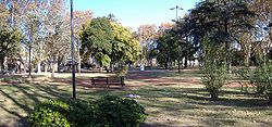
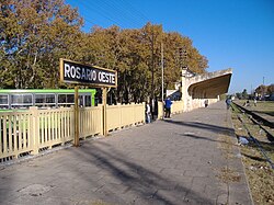
Directly opposite Plaza Ciro Echesortu lies one of the area's most poignant historical sites: the abandoned Rosario Oeste Station, which once served the Ferrocarril Belgrano railway line.
Neighborhood Summary
| Category | Details |
|---|---|
| Official Name | Remedios Escalada de San Martín |
| Western Boundary | Paraná St. / Ferrocarril General Manuel Belgrano |
| Eastern Boundary | Francia Avenue |
| Northern Boundary | Tucumán St. |
| Southern Boundary | Pellegrini Avenue |
| Major Streets | Mendoza St., Avellaneda Blvd, Córdoba St. / Eva Perón Ave |
Frequently Asked Questions
What is the official name of the Echesortu neighborhood?
Administratively, the neighborhood is officially named Remedios Escalada de San Martín, though it is unofficially and commonly referred to as Echesortu.
Who was Ciro Echesortu?
Ciro Echesortu was the original owner of the land that once formed an independent town, which later became part of the city of Rosario.
Where is the Rosario Oeste Station located?
The abandoned Rosario Oeste Station of the Ferrocarril Belgrano is located in the Echesortu neighborhood, situated opposite Plaza Ciro Echesortu.
What are the main boundaries of the neighborhood?
The neighborhood is bounded by Paraná Street and the Belgrano railway to the west, Francia Avenue to the east, Tucumán Street to the north, and Pellegrini Avenue to the south.
Which major streets run through Echesortu?
The primary streets include Mendoza Street, Avellaneda Boulevard, and Córdoba Street (which becomes Eva Perón Avenue south of Avellaneda).