Darién Gap: The Treacherous Land Bridge Between North and South America
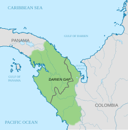
The Darién Gap (Spanish: Tapón del Darién) is one of the most inhospitable regions on Earth. A remote, roadless expanse of rainforest and mountains, it forms a natural barrier on the international border between Colombia and Panama. Stretching across Panama's Darién Province and Colombia's Chocó Department, this rugged terrain serves as the only land bridge connecting North and South America.
Characterized by a massive drainage basin and dense jungle, the region is notorious for its extreme environment and difficult navigation. While it has historically been a vital corridor for wildlife and humans, its lack of infrastructure makes it a formidable obstacle for modern travel.
Geography and Environment
The geography of the Darién Gap varies significantly between the two nations it divides. On the Colombian side, the landscape is dominated by the Atrato River delta, which creates a flat marshland extending at least 80 km (50 mi) in width. The Serranía del Baudó mountain range runs along the Pacific coast, extending into Panamanian territory.
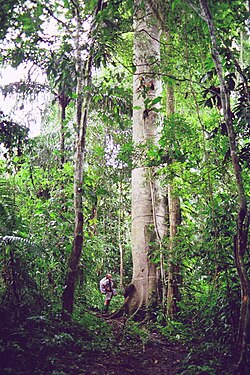
In contrast, the Panamanian side consists of mountainous rainforest. Elevations range from 60 m (197 ft) in the valley floors to the region's highest point, Cerro Tacarcuna, which reaches 1,845 m (6,053 ft) in the Serranía del Darién.
Indigenous Populations and Settlements
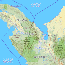
The region is primarily inhabited by the indigenous Guna and Embera-Wounaan peoples. As of 1995, the population among five tribes was reported at approximately 8,000. The most significant settlement is La Palma, the capital of the Darién Province, with roughly 4,200 residents. Other notable population centers include El Real de Santa María and Yaviza.
The Break in the Pan-American Highway
The Pan-American Highway is a massive network of roads spanning approximately 30,000 km (19,000 mi) from Prudhoe Bay, United States, to Quellón, Chile, and Ushuaia, Argentina. However, this system is interrupted by the Darién Gap.
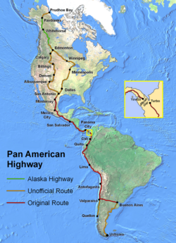
The highway terminates at Yaviza, Panama, and resumes at Turbo, Colombia, leaving a gap of roughly 106 km (66 mi). Despite various attempts in the 1970s and 1990s to bridge this distance, infrastructure development has been blocked by immense financial costs, logistical hurdles, and environmental concerns. Currently, there are no active plans for a road, though discussions regarding rail links or ferry services persist.
Key Facts
- Location: Border between Colombia (Chocó Department) and Panama (Darién Province).
- Highway Gap: Interrupts the Pan-American Highway between Yaviza, Panama, and Turbo, Colombia.
- Highest Point: Cerro Tacarcuna at 1,845 m (6,053 ft).
- Conservation: Home to Darién National Park, the largest national park in Central America (approx. 5,790 km²).
- Migration: Over 520,000 people crossed the gap in 2023.
A History of Exploration and Conflict
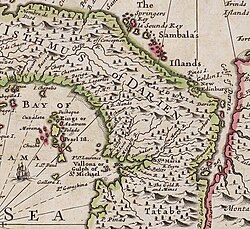
The region's history is marked by early European attempts at colonization and later by daring expeditions. In 1699, the "Darién scheme" saw Scotland attempt to establish a colony in the area, an effort that ultimately ended in disaster.
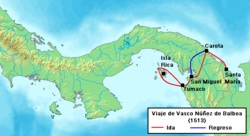
Early explorers like Vasco Núñez de Balboa used the region to reach the "South Sea" in 1513.
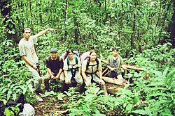
In the 20th century, adventure travelers attempted to conquer the gap. The Trans-Darién Expedition of 1959–60 used a Land Rover and a Jeep to cross from Chepo, Panama, to Quibdó, Colombia, averaging only 201 m (220 yd) per hour over 136 days. In 1961, a team attempted the crossing with Chevrolet Corvairs; while two succeeded, one was abandoned in the jungle.

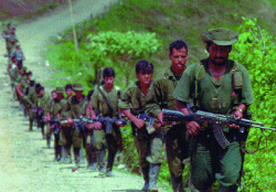
The region has also been a site of instability. The FARC (Revolutionary Armed Forces of Colombia) insurgents have historically operated in the area, and criminal enterprises involving drug and human trafficking remain widespread.
Modern Migration Crisis
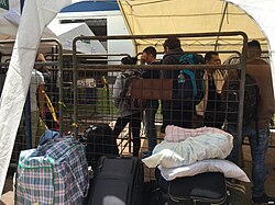
Since the 2010s, the Darién Gap has evolved into one of the world's most heavily used migration routes. Thousands of individuals from Venezuela, Haiti, Africa, South Asia, the Middle East, and China traverse the jungle on foot to reach the United States border.
The volume of crossings has increased dramatically: from 24,000 in 2019 to 250,000 in 2022, and peaking at over 520,000 in 2023. In 2024, numbers dropped to approximately 300,000. The journey, which once took a week, has become more organized, often taking around 2.5 days.
Summary of Regional Data
| Feature | Details |
|---|---|
| Primary Countries | Panama and Colombia |
| Highway Termini | Yaviza (Panama) and Turbo (Colombia) |
| Gap Distance | Approximately 106 km (66 mi) |
| Major National Park | Darién National Park (5,790 km²) |
| Peak Elevation | 1,845 m (Cerro Tacarcuna) |
| 2023 Migrant Volume | 520,000+ individuals |
Frequently Asked Questions
Why is there no road through the Darién Gap?
Construction is hindered by extreme logistical challenges, high financial costs, and significant environmental concerns. Environmental groups and indigenous peoples have historically opposed road development to protect the rainforest.
Who lives in the Darién Gap?
The region is primarily inhabited by indigenous groups, specifically the Embera-Wounaan and Guna peoples, along with small settlements like La Palma.
How dangerous is the crossing for migrants?
The crossing is extremely perilous due to the inhospitable terrain, lack of infrastructure, and the presence of criminal organizations involved in trafficking.
What is the Pan-American Highway?
It is a network of roads roughly 30,000 km (19,000 mi) long that connects North and South America, with the Darién Gap being the only segment where the road is not continuous.
What happened to Copa Airlines Flight 201?
On June 6, 1992, a Boeing 737 flying from Panama City to Cali, Colombia, crashed in the Darién Gap, resulting in the deaths of all 47 people on board.