Colombia–Panama Border and the Darién Gap
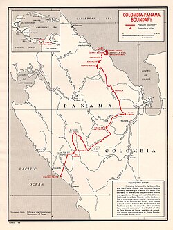
The international boundary between Colombia and Panama stretches 339 kilometers (211 miles), serving as more than just a political line. It bisects the Darién Gap, a formidable region of watersheds, dense forests, and mountains that creates a natural break between the North and South American continents. This rugged terrain is situated within Panama's Darién Province and Colombia's Chocó Department.
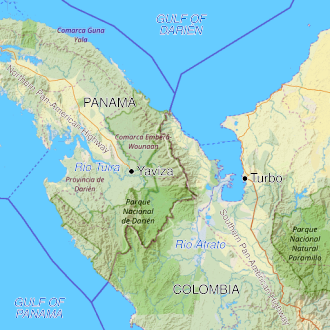
One of the most significant features of this region is the break in the Pan-American Highway. The road ends in Yaviza, Panama, and begins again in Turbo, Colombia, leaving a 106-kilometer (66-mile) gap. Due to the extreme environmental costs and the high expense of construction, no political consensus has been reached to bridge this gap with a road.
Key Facts
- Total Border Length: 339 kilometers (211 miles).
- Highway Gap: A 106 km (66 mi) break in the Pan-American Highway between Turbo and Yaviza.
- Geography: Ranges from flat marshlands in Colombia to mountainous rainforests in Panama.
- Highest Point: Cerro Tacarcuna, reaching 1,845 meters (6,053 ft).
- Indigenous Groups: Home to the Guna and Embera-Wounaan peoples.
Geography and Terrain
The border begins in the north at Cabo Tiburón on the Caribbean coast, winding southwest and southeast through the peaks of the Serranía del Darién range toward Alto Limón. It eventually terminates in the south at Punto Equidistante on the Pacific coast, with a notable Colombian protrusion near Cerro Pirre.
The landscape differs sharply between the two nations. The Colombian side is dominated by the Atrato River delta, which forms a flat marshland at least 80 kilometers (50 miles) wide, half of which is swampland. Conversely, the Panamanian side consists of mountainous rainforests, with elevations ranging from 60 meters (197 ft) in the valleys to the peak of Cerro Tacarcuna at 1,845 meters (6,053 ft).
Historical Context
Pre-Columbian Era
Despite receiving less scholarly attention than neighboring regions, the area contains numerous archaeological sites featuring platform mounds, plazas, paved roads, and artifacts crafted from gold, jade, and ceramics. The region is the ancestral home of the Embera-Wounaan and Guna peoples. The Guna, who migrated from Central America as part of a Chibchan movement, originally lived in the Uraba region before moving westward and toward islands to avoid conflict with the Spanish and to escape mainland mosquito populations.
European Exploration and Settlement
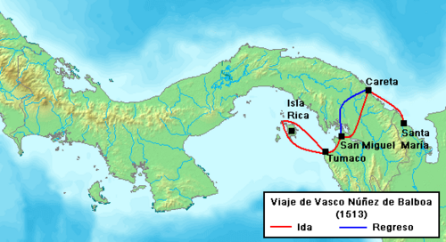
Spanish explorers Alonso de Ojeda and Vasco Núñez de Balboa navigated the coast in 1500 and 1501. In 1513, Balboa became the first European to see the Pacific Ocean from this region. By 1519, the city of Panamá was established as a vital trade port, though it was later destroyed by the pirate Henry Morgan in 1671. The ruins, known as Panamá Viejo, are now a UNESCO World Heritage Site.
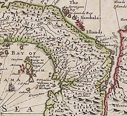
In the late 17th century, Scotland attempted to establish its own colony through the Darien scheme. In 1698, an expedition founded "New Caledonia" with the goal of creating an overland trade route between the Atlantic and Pacific. The colony failed by 1700 due to poor planning, disease, and Spanish military sieges. The resulting financial ruin for the Scottish elite was a contributing factor to the 1707 Acts of Union with England.
Post-Colonial Evolution
Following independence from Spain in 1810, the region was part of Gran Colombia. After the union dissolved, Panama remained part of the Republic of New Granada (later the United States of Colombia). Panama declared its independence in 1903, supported by the United States to facilitate the construction of the Panama Canal. The current border was formally recognized via a 1914 treaty and further solidified by the Victoria-Velez Treaty of 1924.
Modern Challenges and Migration
In recent years, the border has become a focal point for migrant crises. Because the Cuban Adjustment Act of 1966 allows Cubans to receive residency in the U.S., Puerto Obaldia has become a frequent crossing point. When neighboring countries like Costa Rica and Nicaragua closed their borders, Panama followed suit, leading to significant bottlenecks of stranded migrants in the Colombian town of Turbo.
| Feature | Colombia (Chocó) | Panama (Darién) |
|---|---|---|
| Primary Terrain | Atrato River delta / Marshlands | Mountainous Rainforest |
| Key Geography | Serranía del Baudó | Serranía del Darién |
| Highway Status | Ends at Turbo | Ends at Yaviza |
| Indigenous Groups | Embera-Wounaan, Guna | Embera-Wounaan, Guna |
Frequently Asked Questions
Why is there a gap in the Pan-American Highway?
The gap exists because road construction through the Darién Gap is prohibitively expensive and would cause severe environmental damage. Additionally, there has been no political consensus to support the construction.
What was the Darien scheme?
The Darien scheme was an attempt by independent Scotland in 1698 to establish a colony called New Caledonia in present-day Panama to create a trade route between the two oceans. It ended in financial disaster and military defeat by the Spanish.
Who are the indigenous peoples of the Darién region?
The region is primarily home to the Embera-Wounaan and the Guna peoples, who utilize specialized canoes called piraguas for transportation.
How was the current border established?
The border was based on a Colombian law from 1855, recognized by a treaty with the U.S. in 1914, and formally settled between Colombia and Panama through the Victoria-Velez Treaty of 1924.
What is the significance of the Atrato River?
The Atrato River delta creates a vast, flat marshland on the Colombian side of the border, and historically, the river served as the boundary between the colonial governorships of Castilla de Oro and Nueva Andalucía.