County Route 571
County Route 571 (CR 571) is a significant county highway in New Jersey, stretching 43.96 miles (70.75 km) from the coastal regions of Ocean County to the academic hub of Princeton in Mercer County. While the New Jersey Department of Transportation (NJDOT) officially designates it as a north-south route, its actual geographic path runs northwest-southeast. This discrepancy often leads to inconsistent signage, with the road being marked as both north-south and east-west in various sections.
Key Facts
- Total Length: 43.96 miles (70.75 km).
- Termini: Starts at Route 37 in Toms River and ends at Route 27 in Princeton.
- Counties Served: Ocean, Monmouth, and Mercer.
- Maintenance: Managed by Ocean, Monmouth, and Mercer County DOTs, NJDOT, and the municipality of Princeton.
- Major Landmarks: Passes through the Pine Barrens, the Stockton Street Historic District, and the Princeton University campus.
Route Description and Path
Ocean and Monmouth Counties
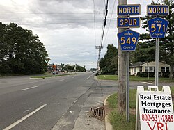
The journey of CR 571 begins at Route 37 in Toms River, Ocean County. Initially, it runs north as a four-lane divided highway on Fischer Boulevard, concurrent with CR 549 Spur. As it progresses through commercial and residential zones, the road navigates near the marshlands of Barnegat Bay before splitting from CR 549 Spur onto Bay Avenue. The route expands again near the Ocean County Mall and Seacourt Pavilion, utilizing an at-grade cloverleaf interchange at CR 549.
Continuing as Bey Lea Road and later Indian Head Road, the highway passes under the Garden State Parkway to reach US Route 9. From there, it joins CR 527 on Whitesville Road before heading northwest into Manchester Township. The route then traverses the Pine Barrens—a unique forested ecosystem—passing through Cassville and eventually forming a concurrency with CR 526 on Trenton-Lakewood Road.
Upon entering Monmouth County, CR 571 passes through Millstone Township. It shares a segment with CR 524 on Stage Coach Road before turning north onto Rising Sun Tavern Road. The route then enters Roosevelt, where it is known as Clarksburg Road, before crossing back into Millstone Township through a landscape of farmland and woodland.
Mercer County
In Mercer County, the highway becomes Etra Road in East Windsor Township, crossing over the New Jersey Turnpike (I-95). In the borough of Hightstown, CR 571 follows a complex path, briefly merging with Route 33 and CR 539. After leaving this concurrency via Stockton Street, it passes through the Stockton Street Historic District and intersects US 130.
As it enters West Windsor Township, the road becomes Hightstown Road and eventually joins CR 526. A notable segment of the route is maintained as state-run Route 64, which carries travelers over the Amtrak Northeast Corridor near the Princeton Junction Station.
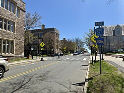
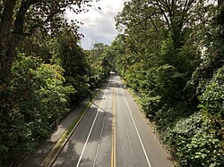
The final stretch follows Washington Road, passing through the historic Washington Road Elm Allée—a scenic corridor of Princeton elm trees. After crossing the Delaware and Raritan Canal and Lake Carnegie, the route enters the heart of the Princeton University campus, terminating at Route 27 (Nassau Street).
Route Summary Table
| Feature | Details |
|---|---|
| Southern Terminus | Route 37, Toms River |
| Northern Terminus | Route 27, Princeton |
| Total Distance | 43.96 miles |
| Primary Counties | Ocean, Monmouth, Mercer |
| Key Junctions | US 9, Route 70, Route 33, US 130, US 1 |
History and Infrastructure
The segment between Hightstown and Millstone Township was established by the Hightstown and Perrineville Turnpike Company, which was chartered in 1859. The CR 571 designation itself evolved over several decades; in the early 1950s, it existed only within Ocean County. By 1962, it extended into Monmouth County, and the full route to Princeton was finalized by 1976.
Traffic management has been a recurring theme at the Penns Neck Circle. In 2012, NJDOT attempted a 12-week pilot program using barriers to prevent left turns from US 1 onto CR 571 to reduce congestion. However, the project was ended early due to resident complaints regarding unsafe U-turns in private driveways. NJDOT has since proposed a realignment involving grade-separated interchanges to improve access to the Princeton Junction Station and US 1.
Frequently Asked Questions
Why is CR 571 signed as both north-south and east-west?
Although NJDOT officially designates it as a north-south route, the road's actual geographic orientation is northwest-southeast, leading to inconsistent signage in different areas.
Which major university campus does CR 571 pass through?
The highway passes directly through the heart of the Princeton University campus before reaching its northern terminus.
What is the Washington Road Elm Allée?
It is a historic section of the route in Princeton characterized by rows of elm trees lining both sides of the road.
How did the route's designation change over time?
Originally limited to Ocean County in the 1950s, the route expanded into Monmouth County by 1962 and reached its current extent to Princeton by 1976.
What happened during the 2012 Penns Neck Circle pilot project?
NJDOT installed barriers to stop left turns from US 1 to improve traffic flow, but the project was cancelled early because drivers began making dangerous U-turns in residential driveways.