Córdoba Street: The Urban Heart of Rosario, Argentina
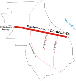
Running east-to-west through the center of Rosario in the Santa Fe Province, Córdoba Street serves as one of the city's most vital arteries. Stretching from the banks of the Paraná River to the western edge of the urbanized area, this thoroughfare connects the city's historical landmarks, commercial hubs, and transport infrastructure.
The street begins its journey near the river at Belgrano Avenue, situated by the National Flag Memorial. From this coastal starting point, it ascends toward the core downtown area, acting as a gateway to the city's administrative and spiritual center.
Historical and Administrative Landmarks
As Córdoba Street traverses the historical center, it passes several of Rosario's most significant institutional buildings. These include the Palacio Vassallo (the legislative house), the Cathedral, and the Central Post Office. The street also leads visitors through Plaza 25 de Mayo and past the Palacio de los Leones, which serves as the city's town hall.
Commercial Hubs and Pedestrian Zones
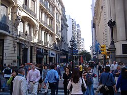
A significant portion of the street is dedicated to foot traffic and commerce. Between Laprida Street and Paraguay Street, Córdoba Street becomes a pedestrian-only zone for seven blocks. This area functions as the city's banking sector and is a dense commercial hub featuring shopping galleries, tourism agencies, and major retail branches such as C&A and Falabella.
Paseo del Siglo
Continuing west from Paraguay Street to Oroño Boulevard, the next eight blocks comprise the Paseo del Siglo (Tour of the Century). This specific stretch is noted for its architectural heritage, with many historical buildings preserved through a dedicated municipal program.
Transit and Urban Expansion
Beyond the historical and commercial core, the street facilitates major city logistics. It passes the Patio de la Madera complex—a multifunctional space featuring a park and lecture rooms used for exhibitions and congresses—as well as the city's Bus Terminal.
Upon crossing Avellaneda Boulevard, the street undergoes a name change, becoming Eva Perón Avenue. Approximately 5 kilometers from its origin, it intersects with Santa Fe Street, transitioning into a two-way road with a narrow central reservation. This section passes the Village Cinemas complex before finally reaching the municipal limit and providing access to National Route 9.
Key Facts
- Location: Rosario, Santa Fe Province, Argentina.
- Orientation: East-west axis.
- Key Landmarks: National Flag Memorial, Palacio de los Leones, and Palacio Vassallo.
- Pedestrian Zone: Seven blocks between Laprida St. and Paraguay St.
- Architectural Zone: Paseo del Siglo (eight blocks from Paraguay St. to Oroño Blvd).
- Name Change: Becomes Eva Perón Avenue after crossing Avellaneda Boulevard.
- Connectivity: Provides direct access to National Route 9.
| Segment/Area | Key Features | Notable Landmarks |
|---|---|---|
| Eastern Start | Coastal connection | National Flag Memorial |
| Historical Center | Administrative core | Palacio de los Leones, Cathedral |
| Pedestrian Zone | Banking and Retail | Falabella, C&A |
| Paseo del Siglo | Preserved Architecture | Historical buildings |
| Western Extension | Transport and Leisure | Bus Terminal, Village Cinemas |
Frequently Asked Questions
Where does Córdoba Street begin?
Córdoba Street starts in the east near the Paraná River at Belgrano Avenue, adjacent to the National Flag Memorial.
Which part of the street is pedestrian-only?
The street is pedestrian-only for seven blocks located between Laprida Street and Paraguay Street.
What is the Paseo del Siglo?
The Paseo del Siglo (Tour of the Century) is an eight-block stretch between Paraguay Street and Oroño Boulevard known for its preserved historical buildings.
Does Córdoba Street change its name?
Yes, after crossing Avellaneda Boulevard, the street changes its name to Eva Perón Avenue.
How does the street connect to national highways?
At its western end, after passing through the suburbs, the street leads to the municipal limit and provides access to National Route 9.