Colonia del Sacramento: A Journey Through Uruguay's Historic Gem
Perched on the banks of the Río de la Plata, facing the bustling skyline of Buenos Aires, Argentina, lies Colonia del Sacramento. As one of the oldest towns in Uruguay and the capital of the Colonia Department, this city is a living museum where Portuguese and Spanish influences blend seamlessly. From its cobblestone streets to its strategic maritime location, Colonia offers a unique glimpse into the colonial struggles and cultural synthesis of South America.
Today, the city is a vibrant mix of old-world charm and modern ambition. While its historic center draws millions of visitors, the city also supports a growing textile industry, a free trade zone, and a polytechnic center. Looking toward the future, the planned development of Colonia Ala Este—a sustainable, Silicon Valley-style hub for the knowledge economy—aims to attract international talent and potentially double the city's population to 60,000.
Key Facts
- Founded: 1680 by Manuel Lobo.
- UNESCO Status: The Historic Quarter (Barrio Histórico) was designated a World Heritage Site in 1995.
- Population: Approximately 32,174 (2023 Census).
- Geography: Located on a peninsula in southwestern Uruguay.
- Climate: Mild humid subtropical (Cfa) with an average annual temperature of 17°C.
- Connectivity: Major ferry hub connecting Uruguay to Buenos Aires, Argentina.
A Turbulent History of Conquest and Treaties
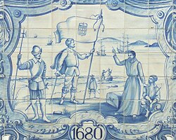
The origins of Colonia del Sacramento are rooted in the territorial ambitions of the Portuguese crown. On January 20, 1680, Manuel Lobo arrived at San Gabriel Island with five ships and 400 personnel to establish a Portuguese post. This move immediately sparked conflict with Spain, leading to a centuries-long cycle of captures and returns.
Throughout the 18th century, the city changed hands multiple times due to various treaties and wars, including the War of the Spanish Succession and the Spanish–Portuguese War. The economy initially thrived on cattle hunting from the Banda Oriental (the eastern bank of the Uruguay River) and smuggling. To secure the settlement, governors like Antonio Pedro de Vasconcellos fortified the city with coastal bastions such as São Pedro de Alcântara and Santa Rita.
By 1816, the area was incorporated into Brazil as the Cisplatina province. Following the Cisplatine War and the subsequent independence of Uruguay, the city became a permanent part of the new republic. This layered history is physically evident in the city's layout: the Portuguese Barrio Histórico features irregular, terrain-following streets, while the newer Spanish sections follow a rigid, orthogonal checkerboard grid.
The Historic Quarter and Points of Interest
The 16-hectare Barrio Histórico is the heart of the city's tourism. Visitors can wander through 17th-century cobblestone streets and explore a variety of architectural landmarks. The area is characterized by its blend of stone and mud houses with traditional tile roofs.
Must-Visit Landmarks
- Basílica del Santísimo Sacramento: A stone basilica built by the Portuguese in 1808.
- Calle de los Suspiros: One of the most photographed and historical streets in the district.
- Portón de Campo: The original city gate featuring a wooden drawbridge.
- Portuguese Museum: An 18th-century building housing naval maps, uniforms, and jewelry.
- Plaza de toros Real de San Carlos: A former bullring now repurposed as a performing arts venue.
Geography, Climate, and Urban Life
Colonia is situated on a peninsula protruding into the Río de la Plata. Its climate is classified as Cfa (humid subtropical), characterized by warm summers and cool winters with frequent fog and frosts. Precipitation is evenly distributed throughout the year, averaging 1,039 mm.
| Attribute | Detail |
|---|---|
| Coordinates | 34°28′17″S 57°50′39″W |
| Total Area | 22.9 km² |
| Elevation | 27 m |
| Population Density | 1,400/km² |
| Time Zone | UTC -3 |
Sports and Culture
Football is a central part of local life. Plaza Colonia, founded in 1917, is the city's professional team, playing at the Estadio Profesor Alberto Suppici. The city also supports futsal, volleyball, and basketball through Club Atlético Plaza.
Transportation and Accessibility
Colonia serves as a critical gateway between Uruguay and Argentina. Three major ferry lines—Buquebus, Colonia Express, and Seacat Colonia—transport approximately 2.5 million passengers annually from Buenos Aires in about 1.5 hours.
For land travel, Route 1 connects the city to Montevideo (180 km east), while Route 21 leads north toward the Aarón de Anchorena National Park. The city is also served by Colonia Airport, located 6 km from the center, with ongoing projects to expand its runway for increased commercial flights.
Frequently Asked Questions
Why is Colonia del Sacramento a UNESCO World Heritage Site?
The city's historic quarter is recognized for its unique blend of Portuguese and Spanish colonial urban planning and architecture, reflecting the contested history of the region.
How do I get from Buenos Aires to Colonia del Sacramento?
The most common method is via ferry. Companies like Buquebus, Colonia Express, and Seacat Colonia operate frequent trips across the Río de la Plata, taking roughly 1.5 hours.
What is the difference between the Portuguese and Spanish parts of the city?
The Portuguese area (Barrio Histórico) is characterized by irregular, winding streets that follow the natural terrain, whereas the Spanish area was planned with a structured, orthogonal grid layout.
What is Colonia Ala Este?
Colonia Ala Este is a planned sustainable "knowledge economy" city designed to attract immigrants and tech professionals, with an initial investment of over US$100 million.
What is the best time to visit based on the climate?
With a mild humid subtropical climate, the city is pleasant year-round, though summers are warm and winters can be cool with frequent frosts, making spring and autumn ideal for exploring the outdoor historic sites.