Chiloé Archipelago
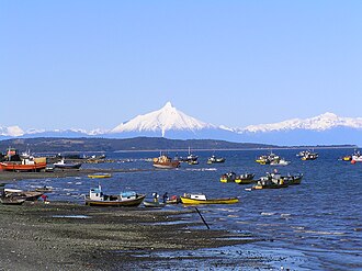
The Chiloé Archipelago is a stunning collection of islands located in the Los Lagos Region of southern Chile. Known for its unique blend of indigenous heritage, colonial history, and rugged natural beauty, the archipelago serves as a bridge between the Chilean mainland and the wild expanses of Patagonia. From its mist-covered forests to its world-renowned aquaculture, Chiloé remains one of the most culturally distinct regions of the country.
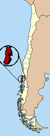
Key Facts
- Capital: Castro
- Total Area: 9,181 km² (approximately 1.21% of Chile's landmass)
- Population: 176,865 (as of 2024)
- Primary Economy: Salmon aquaculture, tourism, agriculture, and timber
- Geography: Comprised of several islands, the largest being Chiloé Island
- Key Landmark: The Chacao Channel, a 2-km wide strait separating the main island from the mainland
Geography and Hydrography
The Chiloé Province encompasses the entire archipelago, including Guafo Island, though it excludes the Desertores Islands. The region is dominated by Chiloé Island, a roughly rectangular landmass covering 8,394 square kilometers. To its east lies the Sea of Chiloé, which houses other significant islands such as Quinchao, Lemuy, and Tranqui.
The landscape is characterized by a stark contrast between its shores. The northern and eastern coasts feature numerous inlets and peninsulas, including the Estero de Castro. In contrast, the western region and Guafo Island are hilly, densely forested, and marked by two north-south mountain ranges: the Piuchén and Pirulil. These ranges reach heights of up to 800 meters and are separated by the lakes Cucao and Huillinco.
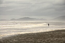
Hydrographically, the region is rich in freshwater. The Huillinco-Cucao lake system, formed by advancing glaciers, is the largest, supported by approximately 200 other smaller lakes and lagoons scattered across the western bogs and forests.
Flora and Fauna
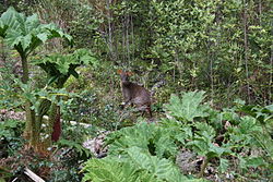
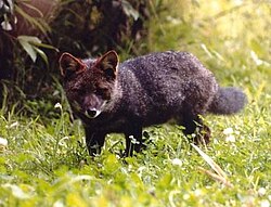
The archipelago is a sanctuary for diverse wildlife. It is home to the southern pudú, one of the world's smallest deer species, which can be found among the native Chilean rhubarb. The region is also a critical habitat for the Darwin's fox (Lycalopex fulvipes), a species endemic to the southern Chilean Coast Range.
History of the Archipelago
Pre-Hispanic and Colonial Eras
Archaeological evidence from nearby Monte Verde suggests the area may have been inhabited as early as 12,000 to 11,800 BC. The first identifiable ethnic inhabitants were the Chonos, a nomadic seafaring people believed to have created the region's abundant shell middens, known as chonchales.
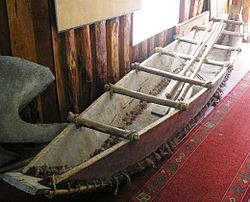
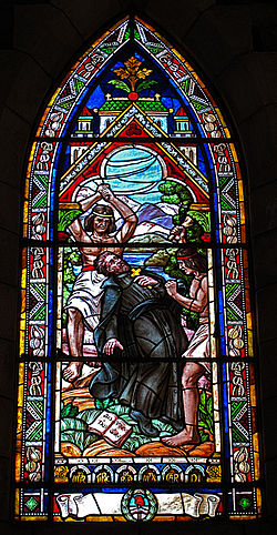
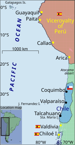
Spanish exploration began in 1553, and by 1567, Captain Martín Ruiz de Gamboa conquered the islands, naming them Nueva Galicia. The settlement of Castro was established that same year, eventually becoming a hub for Jesuit missions. The Jesuits implemented a "circular mission" system, using traditional boats called dalcas to reach scattered populations between September and May.
The Royalist Stronghold
During Chile's struggle for independence, Chiloé remained a staunch loyalist bastion. While the mainland fought for liberation, the Chilote population largely supported the Spanish Crown. It became the last Spanish stronghold in Chile, resisting patriot invasions until January 15, 1826, when it finally surrendered to Ramon Freire.
Integration into the Republic
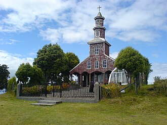
Following its incorporation into the Republic of Chile, Chiloé became a strategic launchpad for southern expansion. It provided the logistical support and manpower for the colonization of the Straits of Magellan, Lake Llanquihue, and Aysén. Thousands of Chilotes migrated to Patagonia to work as independent settlers, railway navvies, or on sheep-raising estancias.
The region's history is also marked by curiosity and tragedy. Charles Darwin visited for six months in 1834, noting the inhabitants' lingering nostalgia for the monarchy. Later, in 1960, the archipelago was devastated by the Great Chilean earthquake, the most powerful ever recorded, which destroyed the cathedral in Ancud and heavily damaged Castro.
Culture and Economy
Chiloé is renowned for its unique cultural identity, including the Chilote Spanish dialect and a deep-rooted belief in mythology and witchcraft. In 1880, these beliefs were so influential that local authorities conducted trials against a secret society of warlocks.
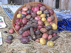
Economically, the region has transitioned from a rural agrarian society to an industrial hub. Today, the economy is driven by salmon aquaculture, with roughly 1,400 farms operating across the islands. This industrialization, accelerated in the 1970s, shifted the population from majority rural to over 60% urban by 2012. Agriculture remains vital, particularly as Chiloé is a global center of diversity for potatoes.
| Category | Details |
|---|---|
| Administrative Center | Castro |
| Main Island Area | 8,394 km² |
| Key Industries | Salmon farming, Tourism, Timber, Potatoes |
| Endemic Species | Darwin's fox |
| Historical Significance | Last Spanish royalist stronghold in Chile |
Frequently Asked Questions
What is a dalca?
A dalca is a traditional type of boat used by the Chonos, Huilliches, and Spaniards in Chiloé, notably utilized by Jesuit priests to navigate the archipelago's scattered missions.
Why was Chiloé important to the Spanish Crown?
In colonial times, Chiloé served as a critical defensive bulwark against potential Dutch and British incursions into Chile and Patagonia.
What is the significance of the 1960 earthquake in Chiloé?
The 1960 Great Chilean earthquake, the most powerful ever recorded, caused massive destruction in the archipelago, including the loss of the Ancud cathedral and severe damage to the capital, Castro.
How has the economy of Chiloé changed recently?
The economy has shifted from traditional rural agriculture to large-scale commercial fishing, salmon aquaculture, and tourism, leading to a significant increase in the urban population.
Which animals are native to the archipelago?
The archipelago is home to the southern pudú (one of the smallest deer in the world) and the endemic Darwin's fox.