Canning: The Rapidly Growing Hub of Buenos Aires Province
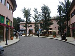
Located southwest of the Buenos Aires metropolitan area, Canning is a town characterized by its rapid expansion and unique administrative position. Situated along Route 52, the town is geographically and politically divided between two partidos (administrative districts), Esteban Echeverría and Ezeiza.
In recent years, Canning has experienced exponential growth. This surge is primarily driven by the proliferation of residential developments and exclusive country clubs, transforming the area into a sought-after residential destination.
Key Facts
- Location: Southwest of the Buenos Aires metropolitan area, Argentina.
- Administrative Division: Split between the partidos of Esteban Echeverría and Ezeiza.
- Primary Access: Located on Route 52.
- Growth Driver: High concentration of gated communities and country clubs.
- Political Status: Currently seeking independence from Ezeiza and Esteban Echeverría.
Demographics and Population
The population of Canning is distributed across its two governing districts. According to the 2001 census conducted by INDEC (the National Institute of Statistics and Censuses), the town had a total of 8,960 inhabitants.
The population breakdown by district was as follows:
- Esteban Echeverría: 6,442 residents.
- Ezeiza: 2,518 residents.
A significant portion of the local population resides within gated communities, reflecting the town's shift toward planned residential luxury.
Neighborhoods and Residential Developments
Canning is composed of numerous residential clusters and country clubs. These neighborhoods are divided by the administrative boundaries of the two districts.
| District: Esteban Echeverría | District: Ezeiza |
|---|---|
| Don Marcelo, Flowers, Tranquility, Deer I, Deer II, Brickland, Mi Refugio, The Centaur, The Rodal, The Mist, Los Rosales, Echeverria Lake, Campos de Echeverria, St. Thomas, Country Club Avacas, Dawns Canning | Providence Resort & Country Club, Solar del Bosque, Sunrise Residence, Sunrise Office, Don Joaquín |
Additionally, the area includes developments such as Blue Field, contributing to the town's diverse residential landscape.
Frequently Asked Questions
Where exactly is Canning located?
Canning is located in the Buenos Aires province of Argentina, southwest of the metropolitan area, positioned on Route 52.
Which administrative districts govern Canning?
The town is divided between the partidos of Esteban Echeverría and Ezeiza.
What has caused the rapid growth of Canning?
The exponential growth is attributed to the development of numerous country clubs and residential gated communities.
What is the current political goal of the town?
Canning is currently fighting for its own independence from the districts of Ezeiza and Esteban Echeverría.
What was the population of Canning according to the 2001 census?
The 2001 INDEC census recorded 8,960 inhabitants, with 6,442 in Esteban Echeverría and 2,518 in Ezeiza.