Caledonian Canal: Scotland's Engineering Marvel of the Great Glen
The Caledonian Canal is a monumental feat of 19th-century engineering that carves a navigable path across the heart of the Scottish Highlands. Stretching approximately 60 miles (100 kilometres) from Inverness in the northeast to Fort William in the southwest, the canal provides a vital link between the east and west coasts of Scotland. By utilizing the natural geography of the Great Glen—a massive geological fault in the Earth's crust—the canal integrates several iconic lochs into its route, blending man-made precision with rugged natural beauty.
Key Facts
- Principal Engineer: Thomas Telford.
- Route: Connects Inverness to Fort William via the Great Glen.
- Composition: Only one-third is man-made; the rest consists of Loch Dochfour, Loch Ness, Loch Oich, and Loch Lochy.
- Infrastructure: Features 29 locks, 4 aqueducts, and 10 bridges.
- Summit: Loch Oich, reaching 106 feet (32 metres) above sea level.
- Completion Date: 1822.
Technical Specifications
To maintain safe navigation, the Caledonian Canal adheres to strict vessel dimensions. These specifications ensure that boats can pass through the various locks and under the numerous swing bridges that span the route.
| Dimension | Maximum Limit (Metric) | Maximum Limit (Imperial) |
|---|---|---|
| Boat Length | 45.72 metres | 150 ft |
| Boat Beam (Width) | 10.67 metres | 35 ft |
| Boat Draft (Depth) | 4.1 metres | 15.5 ft |
| Air Draft (Height) | 35 metres | 115 ft |
History and Planning
The vision for the canal began long before its construction. In 1774, the renowned mechanical engineer James Watt surveyed the route, proposing a 10-foot deep canal to benefit the fishing industry and provide a safer, shorter passage between coasts. He estimated the project would require 32 locks and cost approximately £164,032.
The project gained official momentum with the Caledonian Canal Act 1803, which provided initial funding of £20,000. A subsequent act in 1804 granted an additional £50,000 per year. Under the guidance of principal engineer Thomas Telford, construction progressed through the early 1800s. While the section to Loch Lochy was finished by 1816, the canal could not be fully utilized until the water levels of the lochs were raised and the remaining locks were completed in 1822.
The Northern Section: Inverness to Loch Ness
The journey begins at the Clachnaharry Sea Lock, situated on a man-made peninsula to ensure access to the deep waters of the Beauly Firth. This area is characterized by its historical infrastructure, including a category B listed swing bridge carrying the Far North railway line.
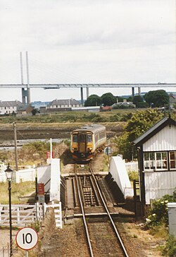
Moving south, the canal passes through the Muirtown Basin and a flight of four locks. A significant feature of this section is the Dochgarroch Lock, a scheduled monument designed to protect the canal from the fluctuating levels of the River Ness. The section concludes at Bona Lighthouse, a rare example of an inland light built by Telford in 1815, before the route opens into the expansive waters of Loch Ness.
The Middle Section: The Summit of the Glen
At the southern end of Loch Ness, the canal enters the village of Fort Augustus, where a series of five locks lift vessels toward the interior. This section is marked by remnants of an abandoned railway project from the early 1900s, including a bridge and several piers over the River Oich.
The canal reaches its highest point at Loch Oich, the summit of the waterway. Sitting 106 feet above sea level, this loch is critical to the canal's operation, providing the majority of the 41.2 million imperial gallons of water required daily to operate the lock systems.
The Southern Section: To the Atlantic Coast
From Loch Lochy, the canal descends toward the west coast. This section is notable for its complex water management, including the Mucomir Cut which feeds a hydroelectric station. One of the most impressive engineering feats is found here: Neptune's Staircase.
Neptune's Staircase is a flight of eight locks that drops the canal level by 64 feet (20 metres) within just 500 yards. Originally operated by 36 manual capstans, the system was mechanized in the 20th century to increase efficiency. Before reaching the final sea locks at Corpach and the waters of Loch Linnhe, the canal crosses several rivers via four distinct aqueducts: the Loy, Muirshearlich, Sheangain, and Mount Alexander aqueducts.
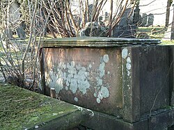
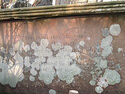
The legacy of the canal's creators remains visible today, from the meticulously placed locks to the resting place of its lead engineer.
Frequently Asked Questions
Who was the lead engineer of the Caledonian Canal?
The principal engineer responsible for the design and construction of the canal was Thomas Telford.
What is Neptune's Staircase?
Neptune's Staircase is a famous flight of eight locks located at Banavie that lowers boats 64 feet (20 metres) over a distance of 500 yards.
How much of the canal is man-made?
Only one-third of the canal's total length is man-made; the remaining two-thirds consist of natural lochs, including Loch Ness and Loch Lochy.
What is the highest point of the canal?
The summit of the canal is Loch Oich, which sits at an elevation of 106 feet (32.3 metres) above sea level.
Which authority currently manages the canal?
The Caledonian Canal is currently under the navigation authority of Scottish Canals.