Bering Strait: The Gateway Between Asia and North America
The Bering Strait serves as the narrow maritime link between the Pacific and Arctic oceans, acting as a physical and political boundary between the Russian Far East and the United States. Named after the Danish-born Russian explorer Vitus Bering, this strait separates the Chukchi Peninsula of Russia from the Seward Peninsula of Alaska.
Beyond its current role as a border, the strait is central to one of the most significant theories in human history: the existence of Beringia. This prehistoric land bridge was exposed when glaciers locked up vast amounts of water, lowering ocean levels and allowing Paleo-Indians to migrate from Asia into North America. This remains the most widely accepted scientific explanation for the peopling of the Americas.
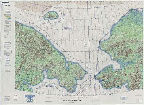
Key Facts
- Narrowest Point: Approximately 82 kilometers (51 mi).
- Maximum Depth: 90 meters (300 ft).
- Border: The maritime boundary between Russia and the US is located at 168° 58' 37" W longitude.
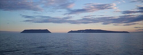
- Key Islands: The Diomede Islands (Big Diomede for Russia, Little Diomede for the US).
- Indigenous Peoples: Home to the Yupik, Inuit, and Chukchi people.
Geography and Environmental Science
The strait is bounded by Cape Dezhnev, the easternmost point of Asia, and Cape Prince of Wales, the westernmost point of North America. To the north lies the Chukchi Sea (part of the Arctic Ocean) and to the south is the Bering Sea. The region is characterized by its shallow waters, with an average depth ranging between 30 and 50 meters.
Geologically, the strait is estimated to have opened between 4.8 and 7.4 million years ago. Some scientists believe that a narrowing of the strait approximately 900,000 years ago may have contributed to the increased duration of the ice age.
A History of Expeditions and Crossings
European interest in the region began as early as 1562 with theories of a "Strait of Anián." While Semyon Dezhnyov likely passed through in 1648, it was Vitus Bering who entered the strait in 1728, and Mikhail Gvozdev who became the first European to cross from Asia to America in 1732. Later, in 1778, the region was visited by James Cook during his third voyage.
In the modern era, the strait has challenged numerous adventurers:
- Dogsled: In 1913, Captain Max Gottschalk became the first documented modern voyager to cross from Russia to Alaska without a boat, using dogsleds via the Diomede Islands.
- Swimming: In 1987, Lynne Cox swam 4.3 kilometers between the Diomede Islands in 3.3 °C water, a gesture of peace during the Cold War. In 2013, a relay team of 65 swimmers completed the first full crossing from Cape Dezhnev to Cape Prince of Wales.
- On Foot: Karl Bushby and Dimitri Kieffer crossed a frozen section in 2006, while a Korean team led by Hong Sung-Taek completed a six-day trek in 2012.
- Vehicles: In 2008, a modified Land Rover Defender 110 became the first amphibious road vehicle to cross the strait.
Proposed Infrastructure and Engineering
The idea of physically linking the two continents has persisted for over a century. In 1864, a Russian-American telegraph line was planned but abandoned in favor of the Atlantic Cable. In 1906, Baron Loicq de Lobel proposed a railroad project authorized by Czar Nicholas II, though it never broke ground.
More recently, Russia discussed a US$65-billion TKM-World Link tunnel in 2011, which would have been the world's longest at 103 kilometers. China has also considered a massive 200-kilometer underwater tunnel as part of a larger railroad connecting China, Russia, Canada, and the US.
Geological Engineering Proposals
Some proposals have aimed to alter the climate. In 1956, the Soviet Union suggested building a 90-kilometer dam to block cold Pacific currents and warm the Arctic Ocean. This was opposed by US intelligence agencies due to national security concerns and by Soviet scientists who feared it would turn northern Siberia into a desert. Conversely, Charles P. Steinmetz once proposed widening the strait to allow the Japan Current to melt the Arctic ice. In the 21st century, dam proposals have shifted toward preserving the ice cap against global warming.
The "Ice Curtain" and Modern Border Control
During the Cold War, the Bering Strait was a tense frontier known as the "Ice Curtain." The Diomede Islands, separated by only 3.8 kilometers, became symbols of this divide. Indigenous peoples, who had historically crossed the border for trade and festivals, were strictly prohibited from doing so.
Today, the Russian coast remains a closed military zone. While foreigners can visit via special permits and designated ports like Anadyr or Provideniya, unauthorized arrivals—even those with visas—face arrest, fines, and deportation.
| Feature | Detail |
|---|---|
| Minimum Width | 82 km (51 mi) |
| Maximum Depth | 90 m (300 ft) |
| Primary Islands | Diomede Islands |
| Connecting Bodies | Arctic Ocean (North) & Pacific Ocean (South) |
| Key Landmarks | Cape Dezhnev (Russia) & Cape Prince of Wales (USA) |
Frequently Asked Questions
Who was the Bering Strait named after?
The strait is named after Vitus Bering, a Danish-born navigator who explored the region on behalf of Russia in 1728.
What is the Beringia land bridge theory?
Beringia is the scientific theory that lower sea levels during the ice age exposed a land bridge, allowing early humans (Paleo-Indians) to migrate from Asia to North America.
How far apart are the Diomede Islands?
Big Diomede (Russia) and Little Diomede (US) are only 3.8 kilometers (2.4 mi) apart.
Can you walk across the Bering Strait?
While some adventurers have crossed frozen sections of the strait on foot, it is not a standard route. Furthermore, the Russian coast is a closed military zone, and unauthorized entry can lead to arrest.
Has a tunnel ever been built across the strait?
No. While several projects have been proposed—including a US$65-billion Russian tunnel and a Chinese railroad project—none have been constructed.