Avenida del Libertador: The Grand Boulevard of Buenos Aires
Avenida del Libertador is one of the most significant and prestigious thoroughfares in Buenos Aires, Argentina. Stretching 25 kilometers (16 miles), this expansive artery connects the Retiro District in the heart of the city to the northern suburb of San Fernando. More than just a road, it serves as a corridor of history, luxury, and culture, reflecting the urban evolution of the Argentine capital.
Key Facts
- Total Length: 25 km (16 mi).
- Route: From Retiro (Buenos Aires) to San Fernando.
- Namesake: General José de San Martín, the Liberator of Argentina, Chile, and Peru.
- Key Districts: Retiro, Recoleta, Palermo, Belgrano, and Núñez.
- Major Infrastructure: Includes the Libertador Tunnel and the parallel Arturo Illia Freeway.
The Evolution of a Metropolitan Icon
The origins of the avenue are rooted in the late 19th-century desire to modernize Buenos Aires. In 1880, Mayor Torcuato de Alvear sought to move away from the restrictive colonial grid of narrow streets, drawing inspiration from Baron Haussmann's urban transformation of Paris. His first major step was the widening and lengthening of Bella Vista Street, which reached 7 km (4.3 mi) into Palermo. Inaugurated in 1885, this stretch was renamed Avenida Alvear in honor of the Mayor's father, Carlos María de Alvear.
As Avenida Alvear became a hub for elite mansions and heavy traffic, Mayor Adolfo Bullrich envisioned a more efficient route to support the upcoming railway terminal in Retiro. This led to the development of a multilane boulevard parallel to the Mitre rail line, which opened in 1906 as Avenida Viceroy Vértiz.
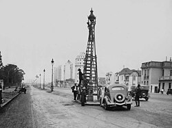
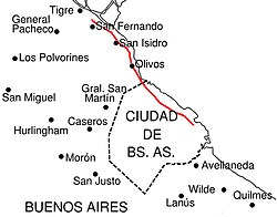
In 1950, by order of President Juan Perón, the avenue was renamed Avenida del Libertador to commemorate the centennial of the passing of General José de San Martín. Throughout the mid-20th century, the road continued to expand. In the late 1930s, a 15 km (9.3 mi) section (Route 195) was built toward San Fernando. Later, in 1968, Mayor Manuel Iricíbar extended the avenue into the Belgrano and Núñez neighborhoods via a tunnel and the widening of Blandengues Street.
To combat severe rush hour congestion, the Arturo Illia Freeway—a toll road running parallel to the avenue—was opened in 1996, providing a vital alternative to the busy junction at Avenida 9 de Julio.
A Journey Along the Avenue
The route begins at the southeast corner of San Martín Plaza, where Avenida Leandro Alem transitions into Avenida del Libertador. As it travels north through the Retiro district, it passes the Retiro railway terminal and the Railway Museum before crossing under the Illia Freeway and the massive Ninth of July Avenue.
Upon entering the Recoleta district, the avenue offers views of Alvear Plaza and the Recoleta Cultural Center. At a major fork, the route splits toward Figueroa Alcorta Avenue, where the National Museum of Fine Arts is located. The stretch through the Palermo district is characterized by some of the city's most valuable residential real estate and passes several cultural landmarks:
- Argentine Automobile Club
- National Museum of Decorative Arts
- Buenos Aires Japanese Gardens
- Tres de Febrero Park
- Palermo Hippodrome
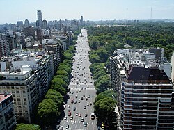
Continuing north, a tunnel opened in 1971 leads the avenue past the Municipal Golf Course into Belgrano. In the Núñez district, the road passes the National Museum of Remembrance, formerly the Navy Mechanics School (ESMA), which served as a primary detention center during Argentina's last dictatorship in the late 1970s.
The final leg of the journey takes the avenue into the Buenos Aires Province via an underpass into Vicente López. The landscape shifts from high-rises and shopping centers in Olivos to the leafy surroundings of San Isidro, passing the Neogothic Cathedral of San Isidro. After a detour via Primera Junta Avenue, the road concludes at the city limit of San Fernando, near the Paraná Delta city of Tigre.
Route Summary
| Section/District | Key Landmarks & Features | Notable Infrastructure |
|---|---|---|
| Retiro | Retiro Railway Terminal, Railway Museum | Illia Freeway Overpass |
| Recoleta | Alvear Plaza, National Museum of Fine Arts | Fork to Figueroa Alcorta Ave |
| Palermo | Japanese Gardens, Tres de Febrero Park | High-value residential areas |
| Belgrano & Núñez | National Museum of Remembrance (ESMA) | Libertador Tunnel (1971) |
| North Suburbs | Cathedral of San Isidro, Tigre canals | Vicente López Underpass |
Frequently Asked Questions
Who is Avenida del Libertador named after?
The avenue is named in honor of General José de San Martín, the Liberator of Argentina, Chile, and Peru. The name was officially adopted in 1950 to mark the 100th anniversary of his death.
How long is the entire avenue?
The thoroughfare extends for a total of 25 kilometers (approximately 16 miles), running from the Retiro District in Buenos Aires to the suburb of San Fernando.
What is the significance of the ESMA building along the route?
The Navy Mechanics School (ESMA) in Núñez was the most important of 340 detention centers operated by Argentina's last dictatorship in the late 1970s. It now serves as the National Museum of Remembrance.
How was the traffic congestion on the avenue addressed?
Traffic was significantly alleviated by the 1996 opening of the Arturo Illia Freeway, a toll road that runs parallel to the avenue and provides an alternative route to the congested junction at Avenida 9 de Julio.
Which Parisian influence shaped the avenue's design?
Mayor Torcuato de Alvear was inspired by Baron Haussmann's modernization of Paris, leading him to replace narrow colonial streets with wide, ambitious boulevards.