Athamanika Ori: The Rugged Peaks of Tzoumerka
Nestled in the northwestern region of Greece, the Athamanika Ori, also widely known as Tzoumerka, stand as a testament to the wild beauty of the Greek highlands. As a significant branch of the Pindus mountain range—the great "spine" of Greece—this region is characterized by its dramatic elevation and remote landscapes.
The range serves as a natural bridge between the administrative regions of Thessaly and Epirus, offering a landscape of steep slopes and high altitudes that define the geography of the area.
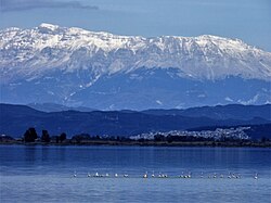
Geography and Dimensions
The Athamanika Ori cover a substantial area of the Greek interior. The range extends approximately 40 kilometers from north to south, while its width varies between 15 and 20 kilometers from east to west. This compact but towering massif creates a formidable barrier and a unique ecological zone.
The Summit of Kakarditsa
The highest point of the range is Mount Kakarditsa. Reaching an elevation of 2,429 meters (7,969 feet), it is the dominant peak of the Tzoumerka region, providing a vantage point that overlooks the surrounding valleys and neighboring peaks of the Pindus system.
Accessibility and Infrastructure
Due to the rugged terrain and steep gradients, the Athamanika Ori remain relatively isolated. The primary artery for transportation through the range is the Greek National Road 30. This critical route connects the cities of Arta, Trikala, Karditsa, and Volos, providing the only major road access across the mountains.
Key Facts
- Alternative Name: Tzoumerka.
- Parent Range: Pindus mountain range.
- Highest Peak: Mount Kakarditsa (2,429 m).
- Location: Northwestern Greece (Thessaly and Epirus).
- Dimensions: ~40 km long and 15–20 km wide.
- Main Access: Greek National Road 30.
| Feature | Detail |
|---|---|
| Highest Point | Mount Kakarditsa |
| Maximum Elevation | 2,429 m (7,969 ft) |
| Coordinates | 39°29′N 21°12′E |
| Regional Location | Thessaly and Epirus, Greece |
| North-South Length | Approximately 40 km |
| East-West Width | 15 to 20 km |
Frequently Asked Questions
What is another name for the Athamanika Ori?
The Athamanika Ori are also commonly referred to as Tzoumerka.
Which mountain range do the Athamanika Ori belong to?
They are part of the wider Pindus mountain range in northwestern Greece.
What is the highest peak in the Tzoumerka region?
The highest point is Mount Kakarditsa, which reaches an elevation of 2,429 meters.
How can one travel across the Athamanika mountains by car?
The only major road crossing the range is the Greek National Road 30, which links Arta, Trikala, Karditsa, and Volos.
Where exactly are the Athamanika Ori located?
They are located in northwestern Greece, spanning the regions of Thessaly and Epirus.