Angra dos Reis: A Coastal Gem of Rio de Janeiro
Located in the southern region of the state of Rio de Janeiro, Angra dos Reis is a stunning municipality renowned for its breathtaking coastline and archipelago. Its name, which translates from Portuguese as "Cove of the Kings" or "Anchorage of the Kings," reflects both its royal history and its natural geography. The city is characterized by its proximity to the sea and a vast territory that includes over three hundred offshore islands, the most prominent being the expansive Ilha Grande.
First documented by Europeans on January 6, 1502, the area has been continuously settled since 1556. Today, it serves as a vital hub for Brazil, balancing a heavy industrial presence with a thriving tourism sector and rich biodiversity.
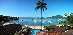
Key Facts
- Founded: January 6, 1502.
- Population: 167,434 (2022 Census).
- Geography: Includes over 300 islands, with Ilha Grande being the largest.
- Climate: Tropical monsoon climate (Am).
- Economy: Driven by tourism, oil transport, shipbuilding, and nuclear energy.
- HDI: 0.724 (High).
History and Evolution
The etymology of Angra dos Reis dates back to the navigator Gaspar de Lemos, who landed at Ilha Grande on January 6, 1502. Because this date coincided with "Dia de Reis" (Kings' Day), the location was named in honor of the occasion.
The municipality's economic trajectory has seen significant shifts. After a period of decline following 1872 due to the rise of railways elsewhere, the city regained prominence in the 1920s. A metre-gauge railway extension connected the port to the states of Minas Gerais and Goias, facilitating the transport of agricultural goods. This line is still operated today by the Ferrovia Centro-Atlântica company.
In the mid-twentieth century, Angra dos Reis became a strategic endpoint for coking coal supplied from Santa Catarina to support the Companhia Siderúrgica Nacional (CSN) in Volta Redonda. The port continues to be used by CSN for steel exports and is one of Brazil's busiest ports due to the TEBIG Petrobras terminal, which handles massive quantities of crude oil.
Economy and Infrastructure
The local economy is diversified, relying on commerce, fishing, services, and industry. A major industrial pillar is the energy sector; the Angra I and Angra II nuclear power stations are located nearby. These facilities employ 3,000 people directly and support approximately 10,000 indirect jobs across Rio de Janeiro State. However, the thermal discharges from these plants cause thermal pollution, warming the surrounding waters.
Tourism is another primary driver, attracting visitors to its clean waters for swimming and scuba diving. The region's allure is further enhanced by its celebrity residents, including the late philanthropist and plastic surgeon Ivo Pitanguy.
Agriculture and Land Use
While industry dominates, there is a modest agricultural sector. The region maintains approximately 4,200 head of cattle and produces various crops, as detailed in the table below:
| Product | Cultivated Area | Production Volume |
|---|---|---|
| Bananas | 1,460 hectares | 3,600 tons |
| Coconut | 10 hectares | 130,000 units |
| Hearts of Palm (Palmito) | 50 hectares | 75 tons |
| Sugarcane | 20 hectares | 390 tons |
| Oranges | 4 hectares | 25 tons |
Geography and Environment
Angra dos Reis covers a total area of 816.3 km². It shares borders with the municipalities of Paraty, Rio Claro, and Mangaratiba in Rio de Janeiro, as well as Bananal and São José do Barreiro in the state of São Paulo.
The region is a sanctuary for biodiversity, featuring several protected conservation units within the 12,400-hectare Tamoios Environmental Protection Area. These include:
- Ilha Grande State Park: A 12,072-hectare park established in 1971.
- Praia do Sul Biological Reserve: A strictly protected 3,502-hectare unit.
- Aventureiro Sustainable Development Reserve: A 1,312-hectare reserve.
- Tamoios Ecological Station: A partial inclusion within the municipality.
The terrain is predominantly hilly, which makes the region susceptible to natural disasters. This was evident in early 2010, when severe landslides caused significant damage to hotels and homes, particularly on Ilha Grande.
Climate Profile
According to the Köppen climate classification, Angra dos Reis has a tropical monsoon climate (Am). This is characterized by high annual precipitation—averaging 1,796 mm—and warm temperatures year-round. The hottest months are typically January and February, with mean daily maximums reaching around 30°C.
Frequently Asked Questions
What does the name Angra dos Reis mean?
The name means "Cove of the Kings" or "Anchorage of the Kings," named by navigator Gaspar de Lemos because he landed there on January 6, 1502, which is known as "Dia de Reis" (Kings' Day).
What is the largest island in the municipality?
The largest island is Ilha Grande (Big Island), which also hosts the Ilha Grande State Park and the Praia do Sul Biological Reserve.
How does the nuclear power plant affect the environment?
The Angra I and Angra II nuclear power stations contribute to the economy by creating thousands of jobs, but they also cause thermal pollution by warming the surrounding seawater through thermal discharges.
What are the main economic activities in Angra dos Reis?
The economy is based on tourism, commerce, fishing, shipbuilding (such as Keppel Fels), oil transport via the TEBIG Petrobras terminal, and nuclear energy production.
What is the climate like in Angra dos Reis?
The city has a tropical monsoon climate, meaning it is generally warm and humid with significant rainfall throughout the year, peaking in December and January.