Ancient Greek Geography: From Homer to the Byzantine Empire
The evolution of geography in the ancient world represents a journey from poetic descriptions of the earth to rigorous mathematical science. Beginning with the early observations of Classical Greece, ancient scholars sought to define the Oikumene—the known inhabited world—through exploration, trade, and intellectual curiosity.
In the earliest stages, geography was often intertwined with epic poetry and early philosophy. Figures like Homer provided the foundational cultural landscape, while Anaximander (died c. 546 BC) and Hecataeus of Miletus (died c. 476 BC) began the transition toward more systematic descriptions of the earth's layout.
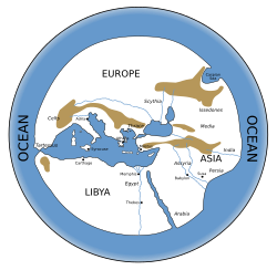
Pre-Hellenistic Classical Greece
During the Pre-Hellenistic period, the focus was primarily on coastal descriptions and the mapping of trade routes. This era saw the rise of the Periplus, a type of manuscript that served as a coastal voyage log, detailing ports and landmarks for sailors.
- Massaliote Periplus (6th century BC) and Scylax of Caryanda (6th century BC) provided critical early maritime data.
- Herodotus (died c. 425 BC) integrated geography with history, describing the vast reaches of the known world.
- Ctesias (c. 401 BC) expanded the Greek understanding of distant eastern lands.
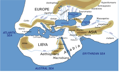
The Hellenistic Period
The Hellenistic era marked a shift toward scientific geography. Scholars began applying mathematics and astronomy to determine the size and shape of the Earth. This period was characterized by an explosion of knowledge following the expansions of the Greek world.
Pytheas (died c. 310 BC) is noted for his daring voyages to the north, while Megasthenes (died c. 290 BC) provided detailed accounts of India. The era reached a scientific peak with Eratosthenes (c. 276–194 BC), who is credited with the first scientific calculation of the Earth's circumference.
Other influential figures included Hipparchus (c. 190–120 BC), who advanced the use of coordinates, and Posidonius (c. 135–51 BC), who continued the study of global dimensions. Later works by Diodorus Siculus and Alexander Polyhistor helped synthesize this vast amount of geographical data.
Geography in the Roman Empire
As Rome absorbed the Greek world, the focus of geography shifted toward administration, empire management, and comprehensive encyclopedias. The Periplus of the Erythraean Sea provided essential data on trade routes between Rome, East Africa, and India.
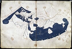
Strabo (63 BC – AD 24) wrote a massive geography that blended physical descriptions with cultural history. Pliny the Elder (AD 23 – 79) documented the natural world in his extensive Natural History. However, the most enduring legacy of this period is the work of Ptolemy (90–168), whose Geography introduced a sophisticated system of longitude and latitude.
Later Roman works include the Tabula Peutingeriana (4th century), a detailed map of the Roman road network, and the Expositio totius mundi et gentium (AD 350–362), which summarized the world's peoples and lands.
The Byzantine Transition
Geography in the Byzantine Empire focused on preserving classical knowledge while updating it for a changing political landscape. Hierocles (6th century) authored the Synecdemus, a list of cities and provinces, while Cosmas Indicopleustes (6th century) provided a unique, though often theological, perspective on the world's shape.
Key Facts
- The Oikumene refers to the inhabited world as understood by ancient geographers.
- Periplus documents were essential maritime guides listing ports and coastal features.
- Eratosthenes was a pioneer in calculating the Earth's circumference during the Hellenistic period.
- Ptolemy revolutionized cartography by introducing a formal system of coordinates.
- The Tabula Peutingeriana served as a critical map of the Roman Empire's road infrastructure.
| Period | Key Figures/Works | Primary Focus |
|---|---|---|
| Pre-Hellenistic | Hecataeus, Herodotus, Scylax | Coastal logs and early world descriptions |
| Hellenistic | Eratosthenes, Pytheas, Hipparchus | Mathematical geography and global measurement |
| Roman Empire | Strabo, Pliny the Elder, Ptolemy | Imperial administration and coordinate systems |
| Byzantine | Hierocles, Cosmas Indicopleustes | Administrative lists and preservation of texts |
Frequently Asked Questions
What is a Periplus?
A Periplus is a maritime log or a coastal guide used by ancient sailors. It typically lists ports, distances, and landmarks along a specific coastline to aid in navigation.
Who was the most influential geographer of the Roman period?
Ptolemy is widely considered the most influential due to his work Geography, which established the use of longitude and latitude for mapping the world.
How did Eratosthenes contribute to geography?
Eratosthenes is famous for using mathematical principles and astronomical observations to calculate the circumference of the Earth with remarkable accuracy for his time.
What was the purpose of the Tabula Peutingeriana?
The Tabula Peutingeriana was a map designed to show the road networks of the Roman Empire, functioning more as a schematic itinerary than a geographically accurate map.
What was the Oikumene?
The Oikumene was the term used by ancient Greeks to describe the entire known inhabited world, encompassing the lands they had explored or heard of through trade and travel.