Yıldırım: A Dynamic Hub of Bursa, Turkey
Nestled at the foot of the majestic Mt. Uludağ, Yıldırım is a vital municipality and district within the Bursa Province of Turkey. Serving as a cornerstone of the Bursa agglomeration alongside the districts of Osmangazi and Nilüfer, Yıldırım blends rich Ottoman history with modern industrial significance. Founded in 1987, the district takes its name from Sultan Bayezid I, whose nickname, "Yıldırım" (meaning "thunderbolt" in Turkish), reflects the strength and speed associated with his reign.
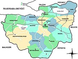
Geographically, the district is positioned in the Marmara region, with the Bursa-Ankara highway passing directly through it, ensuring high connectivity. It is bordered by Kestel and Gürsu to the west and the flat lands of Demirtaş (a subdistrict of Osmangazi) to the north.
Key Facts
- Population: 655,856 (as of 2022), accounting for approximately 30% of Bursa's total population.
- Area: 110 square kilometers (42 sq mi).
- Population Density: 6,000 people per square kilometer.
- Economic Pillar: One of Turkey's most significant centers for textile production.
- Elevation: Ranges from 150–155 meters at the base to high peaks on Mt. Uludağ.
Geography and Infrastructure
Yıldırım's landscape is defined by its dramatic transition from urban city center to alpine heights. While the residential and commercial areas sit at a modest elevation of 150–155 meters, the district extends up the slopes of Mt. Uludağ, reaching significant altitudes at various points.
| Location | Distance (km) | Elevation (MASL) |
|---|---|---|
| Teferrüç, Bursa | 0.0 | 395 |
| Kadıyayla, Uludağ | 2.2 | 1,230 |
| Sarıalan Yaylası, Uludağ | 2.3 | 1,630 |
| Oteller, Uludağ | 4.3 | 1,870 |
The Bursa Uludağ Aerial Lift
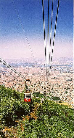
One of the most prominent features of the region is the Bursa Uludağ Aerial Lift (known locally as Teleferik). This aerial tramway provides essential transport to the peaks of Mt. Uludağ. Originally constructed by the Swiss company Von Roll Holding and opened on October 29, 1963, the system underwent a major upgrade in 2013. It was replaced by a modern, higher-capacity gondola lift system engineered by the Leitner Group of Italy.
Economic and Demographic Importance
Yıldırım is not only a residential hub but also an industrial powerhouse. It stands as one of Turkey's primary centers for textile production, contributing significantly to the national economy. Its demographic weight is equally impressive; with a population that grew from 629,702 in 2000 to 655,856 in 2022, it remains one of the most densely populated areas in the country.
Frequently Asked Questions
Who was the district of Yıldırım named after?
The district was named after the Ottoman Sultan Bayezid I, who was known by the nickname "Yıldırım," which translates to "thunderbolt" in Turkish.
What is the primary industry in Yıldırım?
Yıldırım is recognized as one of the most important centers for textile production in Turkey.
How does one reach Mt. Uludağ from the district?
Visitors can use the Bursa Uludağ Aerial Lift (Teleferik), a modern gondola lift system operated by the Leitner Group of Italy.
What percentage of Bursa's population lives in Yıldırım?
Approximately 30% of the total population of Bursa resides within the Yıldırım district.
When was the Yıldırım municipality founded?
The municipality and district were founded in 1987.