Yalu River: The Strategic Border Between China and North Korea
The Yalu River, known as the Amnok River in Korea, serves as a vital natural boundary between the People's Republic of China and the Democratic People's Republic of Korea (North Korea). Stretching nearly 800 kilometers, this waterway is more than just a geographical marker; it is a site of profound historical significance, spanning ancient kingdoms, imperial conflicts, and the intense battles of the 20th century.
From its source high on the slopes of Paektu Mountain to its mouth in the Korea Bay, the Yalu has shaped the political and cultural landscape of Northeast Asia for millennia.
Key Facts
- Length: Approximately 790 km (490 mi).
- Bordering Countries: China (PRC) and North Korea (DPRK).
- Source: South of Heaven Lake on Paektu Mountain.
- Mouth: Korea Bay.
- Major Dams: Sup'ung Dam and Unbong Dam.
- Primary Names: Yālù Jiāng (Chinese) and Amnokgang (Korean).
Geography and Physical Characteristics
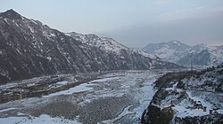
The river begins at an elevation of 2,500 meters (8,200 feet) on Paektu Mountain. It flows south toward Hyesan before turning northwest toward Linjiang, eventually traveling a more southerly route to empty into the Korea Bay between Dandong, China, and Sinuiju, North Korea.
The river drains a massive catchment area of over 30,000 square kilometers. Its most significant tributaries include the Changjin, Hochon, and Togro rivers from the Korean side, and the Ai and Hun rivers from the Chinese side. While the river is not easily navigable for much of its length, it is a critical resource for hydroelectric power and local fishing. During the winter, much of the river freezes, allowing for passage on foot.
Islands and Estuaries
The Yalu contains approximately 205 islands. Following a 1962 border treaty, these islands were divided based on the ethnicity of the inhabitants: North Korea holds 127 islands, while China holds 78. Notably, some islands like Hwanggumpyong belong to North Korea but sit directly adjacent to the Chinese shore. The river's estuary is recognized as an Important Bird Area by BirdLife International.
Etymology and Names
The river's various names reflect the diverse cultures that have inhabited its valley. The Chinese name, Yalu (meaning "duck-green"), dates back to the Tang dynasty and is said to describe the color of the water, resembling a mallard's head. Some scholars suggest the name may actually derive from the Manchu word yalu ula, meaning "the boundary between two countries."
In Korea, the river is called Amnok, which is the Sino-Korean reading of the Chinese name. Ancient historical records also refer to it as Peishui or Mazishui. Another historical Korean name, Arinarye, is thought to combine the Old Korean word for the "spirituality of the sun" (Ari) with a word for "river" (nari).
Historical Significance
Ancient Kingdoms and Imperial Eras
The Yalu River basin was the cradle of the ancient Korean kingdom of Goguryeo. The former capital of this kingdom was located at present-day Ji'an, a site now rich with historical relics. The river has also been a site of major political shifts, such as in 1388, when General Yi Songgye used Wihwa Island as a turning point that eventually led to the establishment of the Joseon dynasty.
Due to its strategic location, the river has been the site of several major military conflicts, including:
- The Battle of the Yalu River (1894) during the First Sino-Japanese War.
- The Battle of Yalu River (1904) during the Russo-Japanese War.
- Battles near the Yalu River (1950) during the Korean War.
The Korean War and "MiG Alley"
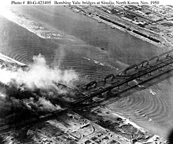
The Yalu played a central role during the Korean War. As United Nations troops approached the river, China intervened on the side of North Korea. The conflict saw the destruction of almost every bridge crossing the river, with the exception of the Sino-Korean Friendship Bridge. The airspace near the western end of the river became famous as "MiG Alley," named after the MiG-15 fighters used by North Korean, Chinese, and Soviet forces.
Economy and Infrastructure
Today, the river is a major source of hydroelectric power. The Sup'ung Dam, one of Asia's largest, stands 106 meters high and has created the artificial Sup'ung Lake. Other significant structures include the Unbong Dam and the Taipingwan Dam. Beyond power, the river supports the timber industry and provides essential fish stocks for local populations.
Key Crossings
Several bridges facilitate movement and trade between the two nations:
- Sino-Korean Friendship Bridge: Connects Dandong, China, to Sinuiju, North Korea.
- Ji'an Yalu River Border Railway Bridge: Connects Ji'an, China, to Manp'o, North Korea.
- New Yalu River Bridge: A major project under construction between Dandong and Sinuiju.
| Feature | Details |
|---|---|
| Total Length | 790 km (490 mi) |
| Primary Countries | China and North Korea |
| Major Tributaries | Changjin, Hochon, Ai, Hun |
| Island Distribution | North Korea (127), China (78) |
| Key Economic Use | Hydroelectric power, fishing, lumber |
Frequently Asked Questions
What does the name Yalu mean?
The name is often interpreted as "duck-green" in Chinese, referring to the river's color. However, it may also be a phonetic approximation of the Manchu term yalu ula, which means "the boundary between two countries."
Which provinces border the Yalu River?
In China, the river borders the provinces of Jilin and Liaoning. In North Korea, it borders the provinces of North Pyongan, Chagang, and Ryanggang.
Is the Yalu River navigable?
The river is not easily navigable for most of its length, though it is used for transporting lumber and supports local fishing activities.
Why is the river significant to the Korean War?
The river was a major strategic boundary. The approach of UN troops toward the Yalu prompted Chinese intervention, and the area became a site of intense aerial combat known as "MiG Alley."
How are the islands in the river divided?
Following a 1962 treaty, the approximately 205 islands were divided between North Korea and China based on the ethnic groups living on them.