Wood Street: A Journey Through London's Roman and Medieval History
Wood Street serves as a fascinating architectural and historical timeline of London, stretching from the remnants of the Roman Empire to the technological expansions of the 20th century. Once a vital artery for trade and movement, the street's layout reveals the hidden footprints of the city's ancient fortifications and its resilience through centuries of fire and war.
Roman Origins and Urban Development
The foundations of Wood Street were laid as the primary north-south route through the Roman Fort, a structure that remained hidden until it was uncovered following the bombing of World War II. The fort's northern boundary was marked by Cripplegate, while the southern gate was situated just south of the junction with Love Lane.
Interestingly, the road diverts slightly to the east at a specific point. Historians suggest this shift occurred because the original Roman gate was either blocked or still in use, forcing builders to break through the fort wall to allow the street to continue its path.
Following the Alfredian restoration of the City around 886 AD, Wood Street evolved into a critical transport link. It connected Queenhithe—the city's main port located at Bread Street—to Cheapside, the primary market street, before extending north through Cripplegate and out of London.
The Spiritual Landmarks of Wood Street
For centuries, the street was home to two significant religious institutions that mirrored the city's triumphs and tragedies.
St Alban, Wood Street
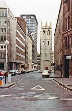
Dedicated to Saint Alban, this church had medieval origins and underwent a rebuild in 1634. However, it was destroyed during the Great Fire of London in 1666. The renowned architect Sir Christopher Wren subsequently rebuilt the church in a Gothic design. The structure suffered severe damage during the Second World War; while the ruins were eventually cleared, the tower remains standing today.
St Michael Wood Street
First mentioned in 1225 as St. Michael de Wudestrate, this medieval church and parish were located on the west side of the street. While it initially faced Huggin Lane, it later shifted its frontage to Wood Street itself.
Modernity and the Telephone Exchange
In the 20th century, Wood Street became a hub for communication. In 1929, it became the site of the country's largest telephone exchange. Despite being bombed during World War II, the facility was rebuilt and later expanded in 1971 to meet growing demands. The exchange finally closed its doors in 1990 and was demolished shortly thereafter.
Key Facts
- Roman Roots: Originally the main north-south route through the Roman Fort.
- Trade Link: Connected the port at Queenhithe to the market at Cheapside.
- Architectural Legacy: St Alban's church was rebuilt by Sir Christopher Wren after the 1666 Great Fire.
- Communication Hub: Hosted the UK's largest telephone exchange from 1929 to 1990.
- Archaeological Discovery: The Roman Fort was rediscovered after WWII bombing.
| Period/Year | Event/Feature | Significance |
|---|---|---|
| Roman Era | Roman Fort Route | Primary north-south transit through the fort |
| c. 886 AD | Alfredian Restoration | Established as a route from Queenhithe to Cheapside |
| 1225 | St Michael de Wudestrate | First mention of the medieval parish church |
| 1666 | Great Fire of London | Destruction of St Alban's; later rebuilt by Wren |
| 1929 | Telephone Exchange | Opening of the nation's largest exchange |
| 1990 | Exchange Closure | End of the site's role as a communication hub |
Frequently Asked Questions
How was the Roman Fort on Wood Street discovered?
The Roman Fort was discovered after the bombing that occurred during World War II.
What was the purpose of Wood Street after 886 AD?
It served as a main road connecting the port at Queenhithe (Bread Street) to the market street at Cheapside, continuing north through Cripplegate.
Who rebuilt St Alban, Wood Street after the Great Fire?
The church was rebuilt in a Gothic design by the architect Sir Christopher Wren.
What remains of St Alban's church today?
Following severe bombing in the Second World War and the subsequent clearing of ruins, only the tower remains.
When did the Wood Street telephone exchange operate?
The exchange opened in 1929 and remained in operation until it closed in 1990.