United Nations Subregions and Global Geographical Divisions
Defining the boundaries of our world is a complex task that varies depending on whether one is looking through the lens of statistics, geology, economics, or culture. The United Nations geoscheme, developed by the United Nations Statistics Division, provides a standardized framework to ensure statistical consistency across global data. By assigning each country or area to a single continental subregion, the UN simplifies the process of international reporting and analysis.
Beyond the official UN classifications, geographers and scientists categorize the Earth's landmasses using various methodologies, including physiography (the study of physical features), biogeography (the distribution of species), and economic alliances.
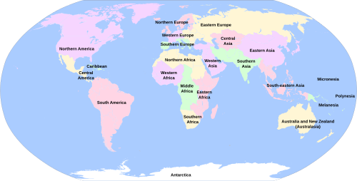
Key Facts
- The UN Statistics Division creates the official geoscheme for global statistical consistency.
- Transcontinental countries, such as Russia, are assigned to a single subregion (Eastern Europe) for statistical purposes.
- Global divisions are categorized by multiple lenses: geography, physiography, economics, culture, and geology.
- The world is broadly divided into major landmasses including Afro-Eurasia, the Americas, Oceania, and Antarctica.
Afro-Eurasia: Africa and Asia
Africa
The UN geoscheme divides Africa into Northern, Sub-Saharan, Eastern, Middle, Southern, and Western Africa. Geographically, the continent is often split between North Africa (Saharan) and Sub-Saharan Africa (Tropical). Physiographically, the region is defined by major basins such as the Congo, Kalahari, and Nile, as well as the Sudanian savannas.
Economically, Africa is organized through various unions and communities, including the African Monetary Union (AMU), the Economic Community of West African States (ECOWAS), and the Southern African Development Community (SADC).
Asia
Asia is one of the most diverse landmasses, divided by the UN into Central, Eastern, Southeast, and Southern Asia. Notably, the UN includes Afghanistan and Iran within Southern Asia. Geographers further refine these areas into regions like Greater China, the Indian subcontinent, and the Middle East (or Near East).
Physiographic markers include the Himalayas, the Tibetan Plateau, and the Malay Archipelago. Economically, the region is shaped by organizations such as ASEAN (Association of Southeast Asian Nations) and APEC (Asia-Pacific Economic Cooperation).
Europe and the Americas
Europe
The UN classifies Europe primarily through its Southern subregion, while geographers divide the continent into Northern, Southern, Western, Central, and Eastern Europe. Physiographically, Europe is characterized by the Great European Plain and the Scandinavian Peninsula.
Europe's economic landscape is dominated by the European Union (EU) and the Eurozone. Historically, the continent is often viewed through the lens of the East-West Schism or the divisions of the Roman Empire.
The Americas
The UN geoscheme splits the Americas into Northern America and Latin America and the Caribbean. Within this, the Caribbean and Central America (which includes Mexico) are distinct subregions. North America is further detailed by the geography of Canada and the United States, including the Great Lakes region and the Canadian Shield.
South America is categorized by the UN as part of Latin America, with geographical divisions including the Andean States and the Southern Cone. The Amazon Basin serves as the primary physiographic feature of the continent.
Oceania and Antarctica
Oceania
Oceania is divided by the UN into Melanesia and Polynesia. Geographically, it encompasses Australia, New Guinea, and the various Pacific Islands. Human geography further distinguishes between "Near Oceania" and "Remote Oceania." Geologically, the region is anchored by the Australian Shield.
Antarctica
Antarctica is treated as a single entity in the UN geoscheme. Geographically, it is split into East Antarctica, West Antarctica, and the Antarctic Peninsula, along with various subantarctic islands such as the Kerguelen and South Georgia islands.
Summary of Regional Classifications
| Perspective | Primary Focus | Example Division |
|---|---|---|
| UN Geoscheme | Statistical Consistency | Sub-Saharan Africa, Southeast Asia |
| Physiography | Physical Landforms | Congo Basin, Himalayas, Amazon Basin |
| Economics | Trade and Finance | EU, ASEAN, ECOWAS |
| Geology | Earth's Crust/Structure | Kaapvaal Craton, Canadian Shield |
Frequently Asked Questions
How does the UN handle transcontinental countries?
For the sake of statistical convenience and consistency, the UN geoscheme places transcontinental countries into only one subregion. For example, Russia is categorized exclusively under Eastern Europe.
What is the difference between geography and physiography?
Geography generally refers to the spatial distribution and boundaries of regions (e.g., West Africa), while physiography focuses on the physical features of the land, such as basins, plateaus, and mountain ranges (e.g., the Nile Basin).
Which countries are included in Southern Asia according to the UN?
In addition to the traditional Indian subcontinent, the UN geoscheme specifically includes Afghanistan and Iran within the Southern Asia subregion.
What are the primary economic divisions in the Americas?
The Americas are largely divided by economic and linguistic frameworks, such as the Community of Latin American and Caribbean States (CELAC) and the North American Free Trade Agreement (NAFTA).
How is Oceania divided in human geography?
In terms of human geography, Oceania is categorized into Near Oceania and Remote Oceania, reflecting different patterns of human settlement and interaction.