Timanfaya National Park: Lanzarote's Volcanic Wonderland
Located in the southwestern region of Lanzarote in the Canary Islands, Timanfaya National Park (Parque Nacional de Timanfaya) offers a glimpse into the raw power of the earth. Spanning 51.07 square kilometres, this unique protected area is entirely composed of volcanic soil, making it the only national park in Spain that is purely geological in nature.
The park serves as a profound testament to the historical and recent volcanism of the Macaronesian region—a biogeographic area comprising the Canary Islands, Azores, Madeira, and Cape Verde. Its stark, otherworldly landscapes are the result of intense seismic activity that reshaped the island's geography centuries ago.
Key Facts
- Location: Lanzarote, Canary Islands, Spain (Municipalities of Tinajo and Yaiza).
- Area: 51.07 square kilometres (19.72 sq mi).
- Established: 1974.
- IUCN Category: Category II (National Park).
- Unique Status: Spain's only entirely geological national park.
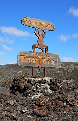
- Symbol: The El Diablo statue designed by artist César Manrique.
Geological History and Evolution
The dramatic terrain of Timanfaya was primarily forged during a massive eruptive period between 1730 and 1736. These eruptions fundamentally transformed the landscape, leaving behind the volcanic vistas seen today. While the most significant changes occurred in the 18th century, the area remained active for another century, with the last recorded volcanic eruptions occurring in 1824.
Visitors to the park can witness the remnants of this activity through various landmarks, including the Manto de la Virgen and the Tremesana trail, which showcase the diverse textures and colors of the volcanic soil.
Administration and Conservation
Established in 1974, the park is managed by the Consejería de Medio Ambiente y Ordenación Territorial. As an IUCN Category II site, the park is managed primarily for ecosystem protection and recreation, ensuring that the fragile geological formations are preserved for future generations.
| Feature | Detail |
|---|---|
| Coordinates | 28°59′39″N 13°47′36″W |
| Total Area | 51.07 km² |
| Governing Body | Consejería de Medio Ambiente y Ordenación Territorial |
| Last Eruption | 1824 |
| Primary Soil Type | Volcanic |
Frequently Asked Questions
What makes Timanfaya National Park unique among Spanish parks?
It is the only National Park in Spain that is entirely geological, meaning its primary value and composition are based on earth sciences and volcanic formations rather than biological diversity alone.
When did the last volcanic eruptions occur in the park?
The last volcanic eruptions in the Timanfaya area took place in 1824.
Which period of eruptions most influenced the current landscape?
The majority of the park's current landscape was transformed during the eruptive period that lasted from 1730 to 1736.
Who designed the symbol of the park?
The statue known as El Diablo, which serves as the symbol of the park, was designed by the artist César Manrique.
Where exactly is the park located?
The park is situated in the southwestern part of Lanzarote in the Canary Islands, Spain, covering parts of the Tinajo and Yaiza municipalities.