The Esplanade: A History of Toronto's Waterfront Evolution
In the 1840s, the area now known as Toronto's waterfront was a rugged landscape of wharves and squatter buildings. At that time, the land where the current Esplanade sits was actually part of the harbour, located south of the original shoreline. The transformation of this aquatic space into a vital urban artery reflects the broader growth of Toronto as a commercial and transportation hub.
The Creation of the Esplanade
The Esplanade was envisioned as a 30-metre-wide (100 ft) road situated just south of Front Street. To make this possible, the city utilized cribbing—a method of using interlocking timber frames filled with stone or earth—and filling to extend the shore southward. This expansion followed a survey line stretching from the Gooderham windmill in the east to a point east of the historic Fort Rouillé.
Completed in the 1850s at a cost of £150,000, the roadway was originally intended for carriages and carts. However, its purpose shifted rapidly as the city's rail infrastructure expanded. In a strategic deal, the railways underwrote the cost of infilling the harbour in exchange for 12 metres (40 ft) of the roadway. By 1865, the project was complete, marking the beginning of railway dominance over the Esplanade west of Yonge Street and much of the surrounding harbour area. To manage the conflict between trains and road traffic, gates were installed at intersections to halt vehicles as trains passed.
The Rise of the Railways and Union Station
The Esplanade became the epicenter of Toronto's rail travel. The Grand Trunk Railway initially established its first station at the intersection of Bay Street and the Esplanade before moving to the first Union Station at York Street and the Esplanade. This facility was replaced by a second Union Station in 1873 at the same location.
The current Union Station, constructed during the 1910s and 1920s, fundamentally changed the landscape. A new viaduct—an elevated bridge-like structure—was built to handle railway functions, permanently removing trains from the surface of the Esplanade. By this time, further landfill had pushed the waterline even further south.
Urban Redevelopment and Modern Transformations
Over the decades, much of the original Esplanade was lost to large-scale urban redevelopment. The road once stretched from Yonge Street to Spadina Avenue, but several landmarks now occupy its former path:
- Metro Toronto Convention Centre: Occupies the area from John Street to Lower Simcoe Street.
- SkyWalk: Spans from Lower Simcoe Street to York Street, covering sites of the former CNCP and Canadian National Express buildings.
- Union Station: Built over the section between Bay Street and York Street.
- Union Station Bus Terminal: Located from Yonge to Bay, utilizing former road sections as internal bus lanes.
In the 1990s, a new section of the Esplanade West emerged between Bay Street and Spadina. This stretch was renamed Bremner Boulevard to honor former Toronto Public Works Commissioner Ray Bremner. More recently, in 2019, the portion of Bremner east of York Street was renamed Raptors Way.
The Great Western Railway and the Fruit Market
The Great Western Railway also left its mark, building a station at Yonge Street and the Esplanade. Once passenger operations shifted to Union Station and the viaduct was completed, this building transitioned from a freight office into the Toronto Wholesale Fruit Market.
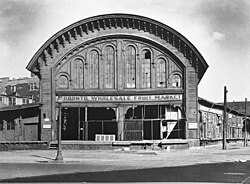
By 1960, the site was repurposed for the O'Keefe Centre for the Performing Arts (now the Sony Centre). Consequently, the fruit market and the adjacent wholesale market near St. Lawrence Market relocated to the Ontario Food Terminal near the Humber River.
Key Facts
- Original Cost: The Esplanade was built in the 1850s for £150,000.
- Width: The road was designed to be 30 metres (100 ft) wide.
- Railway Trade: Railways funded the harbour infill in exchange for 12 metres (40 ft) of the road.
- Timeline: The initial infill and road project were completed by 1865.
- Renaming: The western section became Bremner Boulevard in the 1990s, with a portion becoming Raptors Way in 2019.
| Era/Period | Primary Use/Status | Key Development |
|---|---|---|
| 1840s | Harbour/Waterfront | Wharves and squatter buildings |
| 1850s-1865 | Roadway & Rail | Construction of the Esplanade and harbour infill |
| 1910s-1920s | Transit Hub | Current Union Station and viaduct construction |
| 1960 | Cultural Center | O'Keefe Centre replaces the Wholesale Fruit Market |
| 1990s-Present | Modern Urban Core | Bremner Blvd, Raptors Way, and Convention Centre |
Frequently Asked Questions
What was the original purpose of the Esplanade?
The Esplanade was originally proposed as a 30-metre-wide road for carriages and carts, though it quickly became a primary route for rail lines in Toronto's central core.
How was the land for the Esplanade created?
The land was created through a process of infilling the harbour using cribbing and filling, extending the shoreline south from Front Street.
What happened to the Toronto Wholesale Fruit Market?
The market, which operated out of a former Great Western Railway station, moved to the Ontario Food Terminal by the Humber River in 1960 to make room for the O'Keefe Centre for the Performing Arts.
Which modern streets replaced the western part of the Esplanade?
The section west of Bay Street to Spadina was renamed Bremner Boulevard in the 1990s, and the part east of York Street was renamed Raptors Way in 2019.
How did the railways influence the development of the area?
The railways underwrote the cost of the harbour infill in exchange for a portion of the road. They eventually took over the Esplanade west of Yonge Street and established multiple iterations of Union Station in the area.