Tayrona National Natural Park: A Biodiversity Haven in Colombia
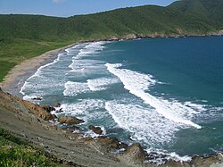
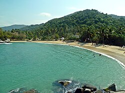
Located in the northern Caribbean region of Colombia, the Tayrona National Natural Park (Parque Nacional Natural Tayrona) is a breathtaking protected area known for its stunning landscapes and immense biological diversity. Situated within the jurisdiction of Santa Marta, approximately 34 kilometers from the city center, the park serves as a vital sanctuary where the mountains of the Sierra Nevada de Santa Marta meet the turquoise waters of the Caribbean Sea.
The park is a geographical marvel, spanning 150 square kilometers of land and roughly 30 square kilometers of maritime area. Its terrain is incredibly varied, ranging from arid sea-level coastlines to elevations of 900 meters above sea level, creating a unique mosaic of climates and ecosystems.
Key Facts
- Established: April 24, 1964, via the 191st Law of the Colombian Institute for Agrarian Reform (INCORA).
- Location: Santa Marta, Magdalena Department, Colombia.
- IUCN Category: Category II (National Park).
- Visitor Volume: 545,760 visitors in 2022, making it Colombia's second most visited national park.
- Conservation Status: One of only three Colombian Caribbean parks featuring coral reefs.
Geography and Climate
The park's boundaries extend from Taganga in the south, following the coastline northeast toward the Piedras River. The interior is defined by a series of hills and peaks, including Santa Rosa Hill, Tovar Hill, Guacamayo Pick, Aguas Muertas Hill, Cielito Pick, and Humo Hill. The landscape is further carved by numerous water sources, such as the Cañaveral, Santa Rosa, La Boquita, and Cinto creeks.
The climate is predominantly tropical and hot. At sea level, temperatures typically fluctuate between 27°C and 35°C (81°F to 95°F). While rainfall varies significantly—ranging from dry periods to peaks of 975 millimeters per month—the region relies heavily on irrigation from streams draining from the snowy peaks of the nearby mountains.
Flora and Fauna
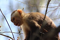
Tayrona is a hotspot for endemic biodiversity (species found nowhere else on Earth). The park is home to an impressive array of wildlife, including 108 mammal species and 300 bird species. Notable residents include the Mantled howler monkey, the oncilla, various deer, and over 70 species of bats.
Avian diversity is particularly high, featuring the montane solitary eagle, military macaw, black-backed antshrike, white-bellied antbird, and the lance-tailed manakin. The park also supports 31 reptile species and 15 amphibian species.
The marine environment is equally rich, boasting 110 species of corals, 202 species of sponges, 471 species of crustaceans, 700 species of molluscs, and 401 species of sea and river fish. On land, the botanical diversity is vast, with over 770 plant species and 350 types of algae.
Archaeology and Recreation
The park holds deep historical significance, with archaeological evidence of human settlements dating back to the 16th century. Visitors can explore the Archaeologic Museum of Chairama at the Cañaveral Site. Popular eco-tourism spots include the Los Naranjos Path, Castilletes Beach, The Pool, and the San Juan Out. Note that the site of El Pueblito has been closed since 2019 to respect the wishes of indigenous residents.
For those drawn to the ocean, Tayrona offers premier recreational scuba diving. The protected shoreline features shallow areas ideal for training, as well as deeper zones with currents suitable for drift diving (a technique where divers float with the current).
Park Summary Table
| Feature | Detail |
|---|---|
| Total Land Area | 150 km² (58 sq mi) |
| Maritime Area | ~30 km² (12 sq mi) |
| Elevation Range | 0 to 900 meters |
| Mammal Species | ~108 |
| Bird Species | ~300 |
| Governing Body | SINAP |
Frequently Asked Questions
When was Tayrona National Natural Park established?
The park was established on April 24, 1964, under the 191st Law of the Colombian Institute for Agrarian Reform (INCORA) to protect the region's ecological environment.
What makes the park's wildlife unique?
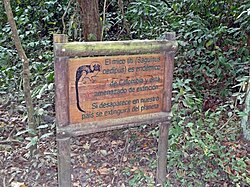
The park is a critical sanctuary for biodiversity, including the endangered cotton-top tamarin, which finds one of its last remaining habitats here, as well as a vast array of endemic species from the Sierra Nevada de Santa Marta.
Can you still visit El Pueblito?
No, the site of El Pueblito has been closed to the public since 2019 in accordance with the wishes of the local indigenous residents.
What activities are available for visitors?
Visitors can engage in eco-tourism through hiking on paths like Los Naranjos, visiting the Archaeologic Museum of Chairama, swimming at Cabo San Juan, or recreational scuba diving in the protected Caribbean waters.
What is the typical weather in the park?
The climate is tropical and hot, with sea-level temperatures generally ranging between 27°C and 35°C (81°F to 95°F).