Subsidence: Causes, Global Impacts, and Measurement Techniques
Subsidence is the general term used to describe the downward vertical movement of the Earth's surface. Unlike slope movement, which involves lateral shifting, subsidence is characterized by little to no horizontal movement. This geological phenomenon can be triggered by a variety of natural processes or accelerated by human activities, often leading to significant environmental and economic challenges.
From the gradual compaction of sediments to the sudden collapse of underground voids, subsidence affects diverse landscapes and urban centers worldwide. Because it can compromise the stability of the ground, it is a primary concern for geologists, geotechnical engineers, urban planners, and landowners.
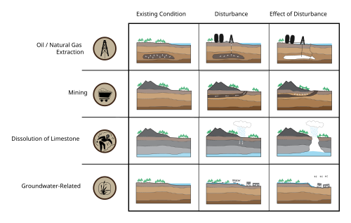
Key Facts
- Definition: Vertical downward movement of the Earth's surface with minimal horizontal shift.
- Primary Human Driver: The pumping of subsurface fluids, such as groundwater and petroleum.
- Extreme Cases: Some locations have experienced subsidence of up to 9 meters (30 ft).
- Economic Impact: Costs associated with subsidence can reach hundreds of millions of US dollars.
- Global Trend: Occurrence is expected to increase due to rising groundwater demand driven by population and economic growth.
Causes of Ground Subsidence
The mechanisms that lead to the sinking of the Earth's surface vary based on the local geology and the presence of human intervention.
Natural Processes
- Dissolution: Groundwater can dissolve underlying carbonate rocks (such as limestone), creating voids that eventually collapse.
- Tectonic Forces: The warping of the Earth's crust, known as tectonic subsidence, can create space for sediments to accumulate and eventually turn into sedimentary rock (lithify).
- Isostatic and Seasonal Effects: Changes in crustal equilibrium and seasonal fluctuations in water levels can cause surface movement.
- Volcanic Activity: The withdrawal of fluid lava from beneath a solidified rock crust can cause the surface to drop.
Human-Induced Activities
- Fluid Extraction: Pumping groundwater or petroleum removes the pressure that helps support the overlying soil and rock, leading to compaction.
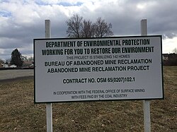
- Mining: The removal of minerals from underground seams can leave unsupported voids, causing the surface above to sink.
- Urban Weight: In some cases, the sheer weight of massive buildings can contribute to local ground settlement.
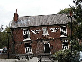
Impacts on Infrastructure and Environment
When the ground sinks, the consequences range from subtle structural tilts to catastrophic failures of critical infrastructure.
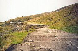
- Infrastructure Damage: Subsidence can cause buildings to lean, walls to crack, and roads to buckle.
- Sinking Cities: Major urban centers built on alluvial or marine sediments are particularly vulnerable to large-scale sinking.
- Increased Flooding: As land elevation drops, the potential for flooding increases, especially in coastal areas.
- Earth Fissures: Severe subsidence can create deep cracks or fissures in the Earth's surface.
![Drivers, processes, and impacts of sinking cities[26]](/images/80/73/807348d2a7cdcb62b1543702d3426726db1431617302f75c1200d49ca82623eb.png)
Measuring and Predicting Subsidence
To mitigate risks, experts use a combination of field measurements and predictive modeling to track how the ground is moving.
Field Measurement Tools
- Surveying: Traditional ground-based measurements of elevation.
- GNSS: Global Navigation Satellite Systems provide precise positioning data.
- InSAR: Interferometric Synthetic Aperture Radar uses satellite imagery to detect millimeter-scale changes in surface height.
- LiDAR: Light Detection and Ranging uses laser pulses to create high-resolution topographic maps.
- Tiltmeters: Instruments used to measure the minute tilting of the ground or structures.
Prediction Methods
Predicting future subsidence involves several approaches: empirical methods based on observation, semi-empirical or statistical methods, and theoretical methods based on physics. Recently, machine learning has been integrated to improve the accuracy of simulations in urban areas.
Global Instances of Subsidence
Subsidence is a global phenomenon, with different regions experiencing varying rates and causes. The following table summarizes notable instances worldwide.
| Location | Primary Cause | Max Rate/Period | Impacts/Measures |
|---|---|---|---|
| Mexico City, Mexico | Groundwater extraction | 387 mm/year (2014-2020) | Significant urban sinking |
| Jakarta, Indonesia | Groundwater extraction | 260 mm/year (1991-1997) | Coastal vulnerability |
| Shanghai, China | Groundwater extraction | 87 mm/year (2019-2020) | Losses >24.57 billion yuan; artificial recharge implemented |
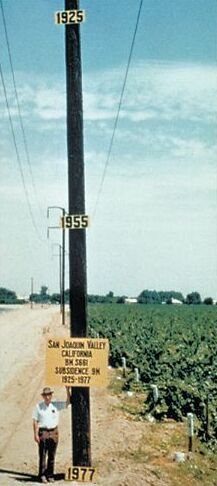
| San Joaquin Valley, USA | Groundwater extraction | 500 mm/year (1923-1970) | Large-scale land deformation |
| Beijing, China | Groundwater extraction | >100 mm/year (2010-2011) | Alluvial sediment compaction |
| La Unión, Spain | Underground mining | 7 mm/year (2003-2004) | Building collapse and damage |
| Venice, Italy | Groundwater extraction | 6.5 mm/year (1952-1968) | Deltaic deposit sinking |
Frequently Asked Questions
What is the difference between subsidence and slope movement?
Subsidence is primarily a vertical downward movement of the Earth's surface with little to no horizontal shift, whereas slope movement involves the lateral displacement of material down a gradient.
How does groundwater pumping cause the land to sink?
When groundwater is extracted from aquifers, the fluid pressure that helps support the soil and rock decreases. This causes the sediments to compact, leading to a drop in the land surface above.
Can subsidence be prevented or reversed?
While some natural subsidence is inevitable, human-induced sinking can be mitigated. Examples include restricting groundwater use, implementing artificial recharge with treated water, and adjusting pumping patterns, as seen in Shanghai.
What are the most accurate ways to measure ground sinking?
Modern geologists frequently use InSAR (Interferometric Synthetic Aperture Radar) and GNSS (Global Navigation Satellite Systems) because they can detect very small changes in elevation over large areas from a distance.
Which types of soil are most prone to subsidence?
Alluvial sediments (deposited by rivers), marine sediments, and lacustrine sediments (deposited in lakes) are highly susceptible to compaction and subsidence.