South Korea Geography: Landscapes, Climate, and Natural Hazards
Located in East Asia on the southern portion of the Korean Peninsula, South Korea is a nation defined by its dramatic coastlines, rugged mountains, and seasonal weather shifts. Situated at approximately 37° North and 128° East, the country occupies a strategic position at the far east of the Asian landmass, bordered to the north by North Korea along a 238-kilometer stretch of the Korean Demilitarized Zone (DMZ).
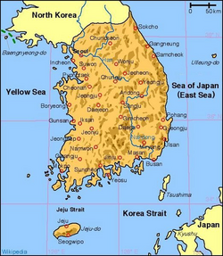
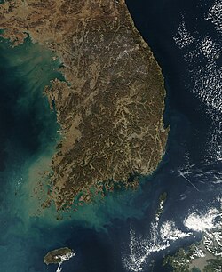
The nation is largely surrounded by water, boasting a 2,413-kilometer coastline that meets three distinct bodies of water: the Yellow Sea to the west, the East China Sea to the south, and the Sea of Japan (known locally as the Donghae) to the east. The landscape is highly indented, featuring approximately 3,579 islands, most of which are clustered along the southern and western coasts.
Key Facts
- Total Land Area: Approximately 100,472.4 square kilometers.
- Topography: Roughly 75% of the landmass is mountainous.
- Highest Point: Hallasan (1,950 m) on Jeju Island.
- Climate Type: Humid continental and humid subtropical with four distinct seasons.
- Major Rivers: Nakdong, Han, and Geum rivers.
- Forest Cover: Approximately 63.9% of the national land area.
Land and Topography
South Korea's terrain is characterized by its mountainous nature. Early visitors often compared the landscape to "the sea in a heavy gale" due to the continuous, successive mountain ranges. These ranges form the topological backbone of the country, with the Taebaek Mountains and the Sobaek Mountains serving as the two primary systems. Many peaks exceed 1,000 meters in elevation.
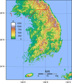
The country's drainage system is dominated by several major rivers that originate in the Taebaek Mountains. The Nakdong River is the longest at 521 km, followed closely by the Han River (514 km), which flows through the capital, Seoul, and the Geum River (401 km). These rivers are generally broad and shallow, experiencing significant seasonal variations in water flow.
Forestry and Land Use
Historically, South Korea faced significant environmental challenges due to deforestation during the early 20th century and the Korean War, which led to soil erosion and flooding. However, aggressive reforestation programs starting in the 1950s and accelerating through the 1970s and 1990s successfully restored the landscape. By 1980, forest cover reached a peak of 65% of the national land area.
Climate and Seasonal Patterns
As part of the East Asian Monsoon region, South Korea experiences four distinct seasons. The climate is heavily influenced by air masses from the Asian continent. Winters are typically long, cold, and dry, while summers are short, hot, and humid. Spring and autumn provide pleasant, though brief, transitional periods.
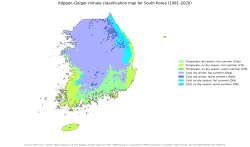
Precipitation is a critical factor for the nation's agriculture. While annual rainfall typically exceeds 1,000 mm, about two-thirds of this precipitation occurs during the summer months between June and September. Jeju Island, located to the south, enjoys a milder and warmer climate compared to the mainland due to its maritime location.
Weather Phenomena: Yellow Dust and Typhoons
During the spring, South Korea often encounters Yellow Dust. This phenomenon occurs when dry, frozen soil in the spring breaks down into fine particles (less than 20 μm) and is carried by strong ascending air currents and westerlies. These dust clouds can persist for 3 to 6 days, primarily from March to May.
The country also faces seasonal typhoons, typically occurring between July and September. While South Korea is less frequently hit than nations like Japan or the Philippines, these storms can bring torrential rains, leading to flooding and landslides. Recent climate change trends suggest a shift, with an increase in autumn typhoons and a rise in the intensity of "super typhoons."
Natural Hazards and Environmental Changes
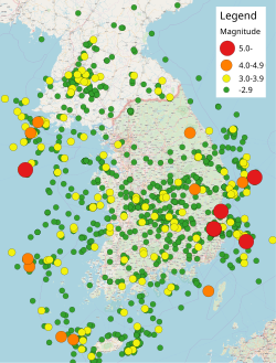
While earthquake activity in South Korea is generally minimal, the region has seen notable seismic events, including two earthquakes exceeding a magnitude of 5.4 since 2016. Additionally, the volcanic cone of Hallasan is considered historically active, though it has not erupted for many centuries.
Climate change is significantly impacting the peninsula. Recent data shows a warming trend, with 2024 recording an average temperature of 14.5 °C—roughly 2 degrees above the 1991-2020 historical average. This warming has contributed to an increase in the frequency and intensity of wildfires. In 2025, a massive wildfire in North Gyeongsang burned 99,289 hectares, marking the largest in the country's history.
Summary of Geographic and Climatic Data
| Feature | Details |
|---|---|
| Highest Elevation | 1,950 m (Hallasan) |
| Lowest Elevation | 0 m (Sea level) |
| Primary Land Cover | Forest (63.9%) |
| Average Annual Rainfall | 1,000 mm to 1,700 mm |
| Major Mountain Ranges | Taebaek and Sobaek |
Frequently Asked Questions
What is the highest point in South Korea?
The highest point is Hallasan, a volcanic cone located on Jeju Island, reaching an elevation of 1,950 meters (6,398 feet).
How does the climate change between seasons?
South Korea has four distinct seasons: long, cold, and dry winters; short, hot, and humid summers; and pleasant but brief spring and autumn periods.
What causes "Yellow Dust" in South Korea?
Yellow Dust is caused by fine sand particles (less than 20 μm) that rise from dry, melting soil in the spring and are carried to the peninsula by strong air currents and westerlies.
Is South Korea prone to earthquakes?
Earthquake activity is generally minimal, though the country has experienced significant events, such as two earthquakes over magnitude 5.4 since 2016.
How has climate change affected South Korea's environment?
Rising temperatures are pushing the peninsula toward a subtropical climate and have increased the frequency and intensity of wildfires.