Sharon Plain
The Sharon Plain (Hebrew: HaSharon; Arabic: Sahl al-Shārūn) is the central section of the Israeli coastal plain. Its name is derived from the Akkadian word "A-Sharanu," which literally translates to "thick forest," reflecting the dense woodland that once dominated the landscape until the late 19th century.
Geographically, the plain is situated between the Mediterranean Sea to the west and the Samarian Hills to the east, which lie approximately 15 kilometers (9.5 miles) inland. It extends roughly 90 km (55 mi) from the Yarkon River in the south—marking the northern limit of Tel Aviv—to Nahal Taninim in the north, a stream that defines the southern boundary of Mount Carmel. The transition between the plain and the sea is marked by the Sharon Escarpment.
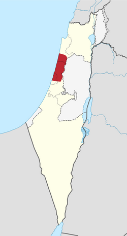
Key Facts
- Location: Central Israeli coastal plain, spanning from the Yarkon River to Nahal Taninim.
- Etymology: Derived from the Akkadian "A-Sharanu," meaning "thick forest."
- Dimensions: Approximately 90 km in length and 15 km wide.
- Ancient Significance: Mentioned in the Bible and ancient Egyptian records.
- Modern Status: One of the most densely populated regions of Israel as of 2008.
Historical Evolution
Ancient Records and Biblical References
The Sharon valley appears in early historical records, including an ancient Egyptian stele of Amenhotep II and the Sarcophagus of Eshmunazar II, where it is described as a field containing both Jaffa and Dor. It is also frequently mentioned in the Bible, most notably in the Song of Songs with the reference to the "Rose of Sharon."
The Forest of Sharon
Historically, the region was a vast open woodland dominated by the Mount Tabor oak (Quercus ithaburensis). This forest, known in Arabic as al-Ghāba, stretched from Ra'anana in the south to Kfar Yona in the north. During the Third Crusade, the "Forest of Arsuf" served as the site for the Battle of Arsuf between Richard the Lionheart and Saladin.
The landscape was not without peril; the region was prone to severe floods. This is reflected in the Mussaf prayer of Yom Kippur, where the High Priest prays that the homes of those living in Sharon do not become their graves.
Deforestation and Modern Transition
The transition from forest to plain began in the 19th century under Ibrahim Pasha, who ordered the oaks razed for construction and heating. This deforestation continued during World War I, as the Ottoman Empire cut down the trees to fuel Turkish trains. The loss of forest cover exacerbated the swampy, malarial conditions of the land.
In the early 20th century, Zionist immigrants began populating the region. By 1945, the Jaffa Subdistrict had a population of 373,800 (71% Jewish, 29% Palestinian Muslim and Christian), while the Tulkarm Subdistrict had 86,120 residents (17% Jewish, 83% Palestinian Muslim and Christian). Following the 1948 Arab–Israeli War, the Arab population largely fled or was expelled.
Archaeological Discoveries
Prehistoric Settlements
Archaeological evidence shows human habitation dating back to the Neolithic period. A primary site of interest is 'En Esur, a multi-level proto-historic site. Excavations revealed an Early Bronze Age planned metropolis covering 65 hectares for roughly 6,000 inhabitants, with an even older settlement beneath it dating back 7,000 years.
Findings at 'En Esur and 'En Zippori include hundreds of standardized sling stones from the Early Chalcolithic period (5800–4500 BCE), which archaeologists suggest indicate organized production and potential warfare.
Bronze and Iron Age Urbanization
The region became heavily populated during the Middle Bronze Age, characterized by a network of fortified cities including Tel Afek, Tel Zeror, Tel Burga, and Tel Poleg. Tel Zeror, located near modern Hadera, was the first major tel (an archaeological mound formed by accumulated debris of ancient settlements) in the plain to be excavated, revealing a fortified 50-dunam city.
Regional Administration and Demographics
Today, the Sharon Plain is divided among the Central, Haifa, and Tel Aviv Districts. It contains several major cities and regional councils.
| City | Approximate Population |
|---|---|
| Netanya | 204,000 |
| Herzliya | 96,000 |
| Kfar Saba | 81,400 |
| Hadera | 76,400 |
| Ra'anana | 73,100 |
| Hod HaSharon | 58,000 |
| Rosh Ha'ayin | 37,500 |
| Ramat HaSharon | 36,800 |
| Tayibe | 33,800 |
Frequently Asked Questions
What does the name "Sharon" mean?
The name is derived from the Akkadian word "A-Sharanu," which means "thick forest," referring to the dense oak woodlands that once covered the region.
What is the "Rose of Sharon"?
The "Rose of Sharon" is a famous and enigmatic reference found in the biblical Book of Song of Songs (2:1), associating the region with beauty and nature.
Why was the Sharon Plain deforested?
Deforestation began in the 19th century under Ibrahim Pasha for heating and construction wood, and continued during World War I to provide fuel for Ottoman Empire trains.
What are the most significant archaeological sites in the area?
Key sites include 'En Esur, which shows habitation from the Neolithic period, and several Middle Bronze Age fortified cities such as Tel Zeror, Tel Afek, and Tel Poleg.
How has the geography of the plain changed over time?
Once a thick forest of Mount Tabor oaks, the region became swampy and malarial following massive deforestation. In the modern era, it has been drained and developed into one of Israel's most densely populated areas.