Sea Breezes and Land Breezes: The Science of Coastal Winds
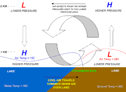
Coastal regions experience a rhythmic shift in wind direction known as sea and land breezes. These localized wind patterns are distinct from prevailing winds and are driven by the fundamental physical differences between how land and water absorb and release heat. While a sea breeze (or onshore breeze) blows from the water toward the land during the afternoon, a land breeze (or offshore breeze) reverses this flow, blowing from the land toward the water at night.
These phenomena occur because of differing heat capacities—the amount of heat energy required to raise the temperature of a substance. Dry land heats up and cools down much faster than water under the same solar radiation, creating the pressure imbalances that drive these winds.
Key Facts
- Sea Breezes: Occur during the day; blow from sea to land.
- Land Breezes: Occur at night; blow from land to sea.
- Primary Cause: Differences in heat capacity between land and water.
- Reach: Sea breezes typically extend 10 to 100 km inland and 1 to 2 km vertically.
- Trigger: A sea breeze requires a temperature difference and is usually suppressed if opposing offshore winds exceed 8 knots (15 km/h).
How Sea Breezes Form
Because the sea has a greater heat capacity than land, it warms up more slowly. After sunrise, the land surface heats the air above it through convection (the transfer of heat by the movement of a fluid). According to the hypsometric equation, hydrostatic pressure depends on temperature; as the land warms, the pressure over the land decreases relative to the air over the cooler water.
This pressure gradient forces the higher-pressure air over the sea to move toward the land at ground level. The strength of this breeze is directly proportional to the temperature difference between the two surfaces.
How Land Breezes Form
As the sun sets, the process reverses. Dry land cools faster than the ocean. When the land becomes cooler than the adjacent sea surface, the air pressure over the water becomes lower than that over the land. This sets up a land breeze that flows from the coast toward the open sea.
Unlike the daytime sea breeze, which is driven by convection, the nighttime land breeze is driven by convergence. These breezes are generally shallower than their daytime counterparts.
The Impact on Weather Patterns
Sea-Breeze Fronts and Convergence
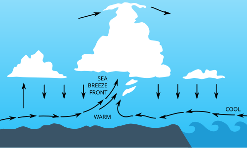
A sea-breeze front is a convergence zone where cool maritime air meets warmer terrestrial air, acting similarly to a shallow cold front. If the air is humid and unstable, this boundary can trigger the formation of cumulus clouds and, in some cases, severe thunderstorms.
Regional Examples: Florida and Cuba
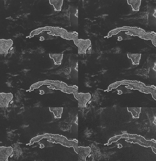
Florida's geography as a peninsula makes it highly susceptible to these patterns. During the wet season (June through September/October), sea breezes from both the Atlantic Ocean and the Gulf of Mexico can collide in the center of the state. This creates intense convergence, making Florida one of the most lightning-prone areas on Earth. These storms can produce significant hail when the upper atmosphere is cooler, such as in spring or fall. Lake Okeechobee can further intensify this activity by generating its own lake breeze.
Similar collisions of northern and southern sea breezes occur in Cuba, often leading to storm development.
The Southerly Buster of Australia
In New South Wales and Victoria, Australia, an intense sea breeze known as the southerly buster occurs. This is a squally wind change with gusts exceeding 40 knots (75 km/h), bringing a dramatic temperature drop of 10 to 15 °C within minutes. This phenomenon is caused by a shallow cold front interacting with the Great Dividing Range, which channels the wind along the coast.
Offshore Weather
Land breezes push warm air upward over the sea. If there is sufficient moisture, this can cause showers or thunderstorms over the water. Because land breezes are weaker than sea breezes, these overnight offshore storms often serve as predictors for the following day's weather on land.
Practical Applications in Energy
The predictable nature of these daily wind fluctuations is utilized by the energy sector. Nearshore wind farms are specifically situated in shallow coastal waters to capture the energy from both sea and land breezes. This differs from deep-water offshore wind farms, which rely on larger-scale prevailing winds.
| Feature | Sea Breeze | Land Breeze |
|---|---|---|
| Timing | Daytime (Afternoon) | Nighttime |
| Direction | Water $\rightarrow$ Land | Land $\rightarrow$ Water |
| Primary Driver | Convection | Convergence |
| Relative Strength | Stronger | Weaker |
| Typical Reach | 10-100 km inland | Shallower/Localized |
Frequently Asked Questions
What is the difference between an offshore breeze and offshore wind?
An offshore breeze (land breeze) is a specific localized wind blowing from land to sea. Offshore wind refers more broadly to any wind occurring over open water, regardless of its cause.
Why does Florida have so much lightning?
Florida's peninsula shape allows sea breezes from both the east and west coasts to collide in the center of the state, creating powerful convergence zones that trigger frequent and severe thunderstorms.
Can a sea breeze be stopped?
Yes. If a strong offshore wind (greater than 8 knots or 15 km/h) is blowing in the opposite direction, it can prevent a sea breeze from developing.
What is a "southerly buster"?
It is an intense sea breeze in southeast Australia characterized by sudden, severe wind gusts and a rapid drop in temperature, often marked by a roll cloud perpendicular to the coast.
How do these breezes affect wind power?
Nearshore wind farms are strategically placed to take advantage of the daily cycle of sea and land breezes to generate electricity.