Salland: The Landscapes and Boundaries of Overijssel
Salland is a diverse region within the Dutch province of Overijssel, characterized by its rich river systems, historic moorlands, and a complex identity that shifts between historical dominion and modern rural definitions. While its borders are not strictly defined, it encompasses a significant portion of the province, blending urban centers with serene natural landscapes.
Defining the Borders of Salland
Historically, the largest definition of Salland corresponds to its historical dominion. In this broad sense, the region is bounded to the west by the provincial border with Gelderland, partially formed by the river IJssel. To the north, it is limited by the Meppelerdiep stream and the border with Drente, which includes the Reest stream. The eastern boundary meets the German state of Lower Saxony and the Twente region of Overijssel, while the southern border touches the Gelderland region of Achterhoek, partially defined by the Schipbeek stream.
Essentially, this expansive definition includes all of Overijssel except for the municipality of Steenwijkerland and the region of Twente.
Geology and Natural Landscape
The geological makeup of Salland is primarily a lowland covered in river sediment (material deposited by flowing water). This has resulted in a low-lying area dominated by rich layers of river clay, shaped by several key waterways. The most prominent is the river IJssel, supported by the Zwarte Water and (Overijsselse) Vecht rivers. Other significant streams include the Schipbeek and the Soestwetering, the latter of which merges with smaller streams near Zwolle to form the Zwarte Water. The Regge stream also passes through Twente before ending in the Vecht near Ommen.
To the east, the landscape shifts toward large moors that were drained to create pastures. These moors, along with the hilly Holterberg region, historically served as the natural boundary with Twente. The Holterberg is particularly notable for preserving stretches of originally vast heathland.
In the northwest, the terrain is marked by reclaimed boglands. These areas were historically used for peat digging, leaving behind low-lying land that was vulnerable to flooding until 1932, when the Zuiderzee was closed off from the North Sea to create the IJsselmeer lake.
Urban Centers and Modern Identity
Under the broadest definition, Salland includes three of Overijssel's major cities: the provincial capital Zwolle, as well as Deventer and Kampen. Other important locations include Ommen and Hardenberg, though these are frequently associated with the "Vechtstreek" (Vecht Region) or "Vechtdal" (Vecht Valley) due to their proximity to the river.
In contemporary usage, Salland is more commonly viewed as the rural area situated between Deventer, Zwolle, Ommen, and Rijssen-Holten. Within this smaller context, Raalte serves as the "unofficial capital." This narrower view is supported by the Salland tourism board, which describes the region as the land lying between the river IJssel and the hills.
Municipal Reforms and the Twente Boundary
The distinction between Salland and Twente has become blurred due to municipal reforms in the early twenty-first century. Some municipalities historically linked to Salland have merged with Twente municipalities, becoming part of the government-defined Twente Region. This includes Den Ham (now part of Twenterand) and Holten (now part of Rijssen-Holten). Additionally, Hellendoorn shifted its association to Twente earlier in the twentieth century due to its location east of the Sallandse Heuvelrug hill ridge and strong commercial ties to the area.
Key Facts
- Population: Approximately 500,000 inhabitants, roughly half of Overijssel's total population.
- Highest Point: Archemerberg hill near Lemele (77 m above sea level).
- Lowest Point: Mastenbroek polder in Kampen (2 m below sea level).
- Major Cities: Zwolle, Deventer, and Kampen.
- Primary Geology: Lowlands with river sediment and reclaimed boglands.
The extreme points of the region provide a clear sense of its geographic scale, from the northern edge of Staphorst to the southern edge of Deventer.
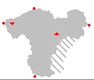
| Extreme Point | Location | Detail |
|---|---|---|
| Northernmost | Staphorst | Northern edge of municipality |
| Southernmost | Deventer | Southern edge of municipality |
| Westernmost | Kampen | Mouth of river IJssel |
| Easternmost | Hardenberg | Eastern edge of municipality |
| Highest | Ommen | Archemerberg (77 m) |
| Lowest | Kampen | Mastenbroek polder (-2 m) |
Frequently Asked Questions
What is the difference between the historical and modern definition of Salland?
The historical definition covers almost all of Overijssel except for Twente and Steenwijkerland. The modern definition is more restrictive, focusing on the rural area between Deventer, Zwolle, Ommen, and Rijssen-Holten.
Which cities are located within Salland?
The primary cities associated with Salland are Zwolle (the provincial capital), Deventer, and Kampen.
How has the landscape of Salland been shaped?
The landscape is primarily shaped by river sediment and clay deposited by rivers like the IJssel and Vecht, as well as human intervention through the draining of moors for pasture and peat digging in boglands.
Why has the boundary between Salland and Twente changed?
The boundary has blurred due to early 21st-century municipal reforms where some Salland-associated municipalities merged with Twente ones, and earlier shifts based on commercial ties and geography, such as in the case of Hellendoorn.
What is the highest point in Salland?
The highest point is the Archemerberg hill, located near Lemele in the municipality of Ommen, reaching 77 meters above sea level.