River Dee: From the Cairngorm Peaks to the North Sea
The River Dee is one of Scotland's most iconic waterways, carving a path from the rugged highlands of the Cairngorms to the industrial hub of Aberdeen. Known for its dramatic landscapes and historical significance, the river serves as a vital artery through the heart of the northeast, transitioning from a mountain stream to a tidal estuary.
The Upper Reaches: A High-Altitude Beginning
The journey of the River Dee begins at an extraordinary elevation. It rises from a spring on the Braeriach plateau in the Cairngorm Mountains at approximately 1,220 meters. This marks the highest source of any major river in the British Isles. The river first emerges through a series of pools known as the Wells of Dee before crossing the plateau toward the cliff edge.
At this precipice, the water transforms into the Falls of Dee, plunging dramatically into An Garbh Choire (translated as the "burn of the rough corrie").
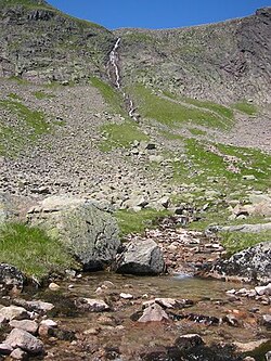
As it continues its descent, the Dee is joined by a tributary from the Pools of Dee in the Lairig Ghru—a high mountain pass. The river flows south between the peaks of Ben Macdui and Cairn Toul, cascading over the falls in the Chest of Dee. Upon reaching White Bridge and meeting the Geldie Burn, the river shifts its course toward the east.
Linn of Dee and Historical Significance
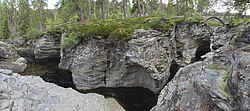
One of the river's most striking features is the Linn of Dee, where the water passes through a 300-meter natural rock gorge. This scenic location was a favorite of Queen Victoria during her visits to Balmoral; in 1857, she officially opened the bridge that spans the river at this point.
Between the Linn of Dee and the village of Braemar, the river grows in volume as it is joined by the Quoich Water and the Lui Water (which is formed by the confluence of the Derry and Luibeg burns). At Braemar, the River Clunie also enters the Dee. The area is not only naturally beautiful but historically rich, with archaeological evidence of human activity dating back to approximately 8,200 BC found along the riverbanks.
Strathdee and the Journey to the Coast
As the river enters the region known as Deeside, it flows through a series of picturesque settlements, including Braemar, Balmoral Castle, Ballater, Dinnet, Aboyne, and Banchory. The river remains within the boundaries of the Cairngorms National Park until it reaches Dinnet.
Several key tributaries feed the Dee during this stretch:
- River Gairn: Flows in from the north near Ballater.
- River Muick: Flows from Loch Muick to the south near Ballater.
- Water of Tanar: Joins the river at Aboyne after flowing through Glen Tanar.
- Water of Feugh: Meets the Dee near the Falls of Feugh at Banchory.
- Coy Burn: Enters the river at Milton of Crathes.
The Tidal Limit and Aberdeen Harbour
The river's transition to a tidal waterway occurs just above the Bridge of Dee. Built around 1720, this bridge carries the A90 trunk road, the primary southern route into Aberdeen. To optimize the river's flow into the sea, an artificial channel was constructed in 1872 to straighten its path.
The river concludes its journey at Aberdeen Harbour. This site is a critical economic hub, serving as the principal marine center for Europe's energy industry, specifically supporting offshore oil and gas operations. At the eastern end of the harbour lies Footdee (locally known as "Fittie"), a historic fishing village.
Key Facts
- Highest Source: The Dee has the highest source of any major British Isles river (1,220 m).
- Ancient History: Human habitation along the banks dates back to c. 8,200 BC.
- Royal Connection: Queen Victoria opened the Linn of Dee bridge in 1857.
- Economic Role: The mouth of the river supports Europe's primary energy industry marine center.
- National Park: The river flows through the Cairngorms National Park until Dinnet.
| Section | Key Landmarks | Major Tributaries |
|---|---|---|
| Upper Reaches | Braeriach Plateau, Lairig Ghru | Geldie Burn |
| Linn of Dee / Braemar | Natural Rock Gorge, Braemar | Lui Water, Quoich Water, River Clunie |
| Strathdee | Balmoral, Ballater, Banchory | River Gairn, River Muick, Water of Tanar, Water of Feugh |
| Estuary | Bridge of Dee, Aberdeen Harbour | Coy Burn |
Frequently Asked Questions
Where does the River Dee start?
The River Dee rises from a spring on the Braeriach plateau in the Cairngorm Mountains at an altitude of approximately 1,220 meters.
What is the significance of the Linn of Dee?
The Linn of Dee is a 300-meter natural rock gorge that was a favorite spot of Queen Victoria, who opened the bridge spanning the river there in 1857.
Which national park does the river flow through?
The River Dee flows through the Cairngorms National Park from its source until it reaches the town of Dinnet.
What is the economic importance of the river's mouth?
The river ends at Aberdeen Harbour, which serves as the principal marine center for the European energy industry, specifically the offshore oil and gas sector.
How old is the human activity found along the River Dee?
Archaeological evidence indicates that human activity along the banks of the Dee dates as far back as approximately 8,200 BC.