Riet River: A Vital Tributary of the Vaal River
The Riet River is a significant westward-flowing waterway located in the heart of central South Africa. Serving as a key tributary to the Vaal River, it traverses a landscape that spans two provinces, playing a crucial role in the region's hydrology and agricultural support.
Etymology and Cultural History
Long before colonial records, the river was known by its native name, Gama-!ab (also referred to as Gmaap). In the !Kora language, this name translates to 'muddy,' a descriptive term reflecting the river's natural characteristics.
Geography and Course
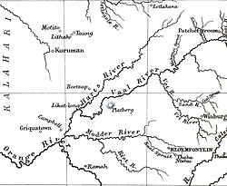
The Riet River begins its journey near the town of Smithfield in the eastern Free State. From its source, it flows westward for approximately 300 kilometers. Along its course, it receives its primary tributary, the Modder River. Following this confluence, the Riet continues its westward path until it reaches its mouth at the Vaal River, upstream from the town of Douglas in the Northern Cape.
Water Management and Infrastructure
The river's flow is managed through several key infrastructure projects designed to support local agriculture. The Riet flows through the Kalkfontein Dam, a critical reservoir for the area. To enhance water availability and quality, water is transferred from the Orange River at the Vanderkloof Dam and fed into the Riet River at Jacobsdal.
This strategic transfer serves two primary purposes: it provides essential water for irrigation and helps lower the salinity levels of the river water. Additionally, when the Vanderkloof Dam experiences excess water spills, that surplus is transferred into the Kalkfontein Dam.
Key Facts
- Native Name: Gama-!ab ('muddy' in !Kora).
- Total Length: 300 km (190 mi).
- Source: Near Smithfield, Free State.
- Mouth: Vaal River, upstream from Douglas.
- Primary Tributary: Modder River.
- Key Infrastructure: Kalkfontein Dam and water transfers from Vanderkloof Dam.
River Specifications Summary
| Feature | Detail |
|---|---|
| Country | South Africa |
| Regions | Free State, Northern Cape |
| Mouth Elevation | 1,001 m (3,284 ft) |
| Flow Direction | Westward |
| Confluence Coordinates | 28°59′58″S 23°53′17″E |
Frequently Asked Questions
What does the native name Gama-!ab mean?
The name Gama-!ab comes from the !Kora language and means 'muddy'.
Where does the Riet River originate and end?
The river originates near Smithfield in the eastern Free State and ends at its confluence with the Vaal River, upstream from Douglas in the Northern Cape.
Which is the main tributary of the Riet River?
The Modder River is the main tributary of the Riet River.
How is the salinity of the Riet River managed?
Salinity is lowered by feeding water from the Orange River (via the Vanderkloof Dam) into the Riet River at Jacobsdal.
What is the purpose of the water transfer at Jacobsdal?
The transfer provides necessary water for irrigation and helps reduce the river's salinity.