Port Arthur: Geography, Climate, and Environmental Resilience
Located on the eastern edge of Jefferson County, Port Arthur serves as a critical coastal hub on the west side of Sabine Lake. Its unique positioning makes it a gateway between Texas and Louisiana, bordered to the northeast by Orange County, Texas, and to the southeast by Cameron Parish, Louisiana. The city's reach extends from the Neches River in the north down to the Gulf of Mexico in the south, following the west side of the Sabine Pass.
The city encompasses a total area of 144.1 square miles. Of this, 76.9 square miles are land, while 67.1 square miles—approximately 46.61% of the total area—consist of water.
Key Facts
- Location: Eastern Jefferson County, Texas, bordering Sabine Lake and the Gulf of Mexico.
- Water Coverage: 46.61% of the city's total area is covered by water.
- Climate: Humid subtropical, tied for the most humid city in the contiguous United States.
- Conservation: Home to numerous Wildlife Management Areas (WMAs) and National Wildlife Refuges.
- Extreme Weather: Highly susceptible to tropical cyclones and significant flash flooding.
Conservation and Natural Landscapes
Port Arthur and the surrounding Gulf Coast are integral to Texas's conservation efforts. The region is part of a network of 50 Wildlife Management Areas (WMAs)—protected zones managed for wildlife and habitat preservation—which collectively cover 748,768 acres across the state.
Local conservation highlights include:
- J.D. Murphree WMA: Spanning 25,852 acres, including the Big Hill Unit (8,312 acres), Salt Bayou/Lost Lake Unit (4,074 acres), and the Hillebrandt Unit (591 acres).
- Candy Cain Abshier WMA: A 207-acre protected area.
- Other Protected Sites: Walter Umphrey Park (Keith Lake unit), the Sabine Woods sanctuary, Sea Rim State Park, and the McFaddin and Texas Point National Wildlife Refuges.
Local Communities
The city of Port Arthur is composed of several distinct communities, including:
- El Vista
- Griffing Park
- Lakeview
- Pear Ridge
- Port Acres
- Sabine Pass
- West Side
Climate and Humidity
Port Arthur experiences a humid subtropical climate (Köppen classification: Cfa), characterized by hot summers and mild winters. Notably, it is tied with Astoria, Oregon, and Lake Charles, Louisiana, as the most humid city in the contiguous United States. Humidity levels typically average 90% in the morning and 72% in the afternoon.
| Metric | Winter (Jan) | Summer (Jul) | Annual Average |
|---|---|---|---|
| Mean Maximum Temp (°F) | 77.4 | 97.0 | 99.3 (Record High) |
| Mean Daily Minimum Temp (°F) | 43.8 | 74.6 | 60.2 |
| Average Precipitation (inches) | 5.32 | 6.85 | 62.13 |
| Average Relative Humidity (%) | 79.0 | 80.7 | 78.4 |
History of Tropical Cyclones
Due to its coastal location, Port Arthur has a long history of battling severe tropical weather. These events have shaped the city's infrastructure and emergency protocols.
Early Disasters and Mid-Century Storms
On September 12, 1897, a major hurricane struck during celebrations for the completion of the Kansas City, Pittsburg and Gulf Railroad. The storm brought five feet of water into the streets and caused a railroad roundhouse to collapse, resulting in 13 deaths and severe damage to a pleasure pier.
In June 1957, Hurricane Audrey made landfall as a category 3 storm just east of the city in Cameron Parish, Louisiana, causing extensive wind damage throughout Port Arthur.
Modern Major Hurricanes
The 21st century has brought several significant challenges:
- Hurricane Rita (2005): A category 3 storm that produced wind gusts of 116 mph, causing widespread wind damage and power outages that lasted several weeks.
- Hurricane Humberto (2007): A category 1 storm that caused relatively minor wind damage, with gusts of 84 mph recorded at the Southeast Texas Regional Airport.
- Tropical Storm Edouard (2008): Produced light effects with wind gusts up to 55 mph.
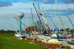
- Hurricane Ike (2008): While a category 2 storm, its massive size caused significant wind damage and power loss. However, the Port Arthur seawall successfully prevented the major flooding seen in neighboring cities.
Recent Extreme Weather Events
Hurricane Harvey (2017) remains one of the most devastating events in the city's history. After making a second landfall as a tropical storm, it dropped 26 inches of rain in a single day. This triggered catastrophic flash flooding, with Mayor Derrick Freeman reporting that 20,000 homes were flooded with up to 6 feet of water.
More recently, in August 2020, the city was evacuated in anticipation of Hurricane Laura. While the city was in the direct path, the storm turned north and made its final landfall near Cameron, Louisiana.
Frequently Asked Questions
What makes Port Arthur's climate unique?
Port Arthur is tied for the title of the most humid city in the contiguous United States, with a humid subtropical climate and average relative humidity levels reaching 90% in the mornings.
How much of Port Arthur is covered by water?
Approximately 46.61% of the city's total area of 144.1 square miles is covered by water, totaling 67.1 square miles.
Which hurricane caused the most flooding in Port Arthur?
Hurricane Harvey in 2017 caused extreme flooding, with 26 inches of rain falling in one day and approximately 20,000 homes experiencing up to 6 feet of water.
What role did the seawall play during Hurricane Ike?
The Port Arthur seawall protected the city from the major flooding that affected surrounding cities during the storm, although the city still suffered significant wind damage and power outages.
What are some of the major conservation areas in the region?
Key areas include the J.D. Murphree Wildlife Management Area, the Candy Cain Abshier WMA, Sea Rim State Park, and the McFaddin and Texas Point National Wildlife Refuges.