Palestine: A Comprehensive History and Demographic Overview
Palestine is a region of profound historical, religious, and geopolitical significance located in the Southern Levant. Known by various names across millennia—including Palaestina in Latin and Filastin in Arabic—the land has served as a crossroads for civilizations, empires, and faiths. From the ancient city-states of the Iron Age to the modern administrative complexities of the 21st century, the region's identity has been shaped by a continuous succession of governing powers.
The region is characterized by its diverse ethnic and linguistic tapestry, primarily comprising Arabs, Jews, and Samaritans, with Arabic and Hebrew serving as the primary languages. Its central hub, Jerusalem, remains one of the most contested and revered cities in the world.
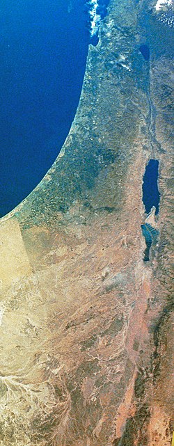
Key Facts
- Ancient Origins: The region includes the historical area of Philistia and the ancient kingdom of Judea.
- Roman Transition: Following the Bar Kokhba revolt in 135 CE, the Romans renamed the province of Judaea to Syria Palaestina.
- Demographic Shifts: Population compositions have fluctuated significantly from the 1st century CE through the Ottoman and British Mandate periods.
- Modern Administration: Current governance is split between the Palestinian National Authority and Israeli administration, with varying levels of international recognition.
- Major Cities: Jerusalem serves as the largest city and a focal point of religious and political importance.
Historical Evolution
Ancient and Classical Antiquity
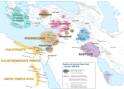
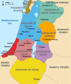
In the early Iron Age, the region was home to various entities, including Philistia. By approximately 1000 BCE, the area was a critical part of the broader Ancient Near East context.
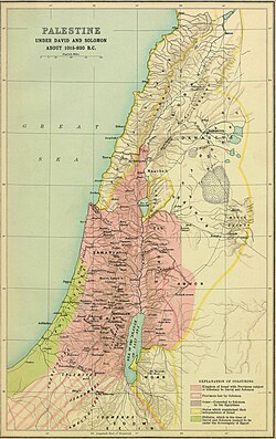
During the classical period, the land was known as Judea under various Greek and Roman administrations. However, after the severe suppression of the Bar Kokhba revolt (132–135 CE), the Roman Empire sought to "de-judaize" the province, officially renaming it Syria Palaestina.
The Middle Ages and Early Muslim Period
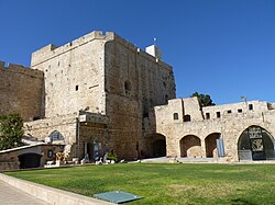
The transition to the early Muslim period brought new architectural and administrative achievements. The region later became a central theater for the Crusades, leading to the establishment of Crusader states and subsequent Ayyubid and Mamluk rule. Cities like Acre became vital strategic ports, featuring massive fortifications such as the Hospitaller fortress.
Ottoman and British Mandate Eras
Under Ottoman rule, the region was administered through various districts, with Jerusalem emerging as a significant administrative center. The Ottomans maintained a diverse population of Muslims, Christians, and Jews. Following World War I, the region transitioned to the British Mandate, a period of intense demographic change and rising national tensions.
![Map of Arabian Peninsula, Kitab-ı cihannüma [Istanbul, 1732] by Katip Celebi. 'Ard Filastin ("The Land of Palestine") is depicted as lying between the two capitals of Jerusalem and Damascus, both bestowed the honorific Sharif (Quds Sharif and Sham Sharif)](/images/56/39/563926cd0ed7cce17a7d8478f11a2ca21dc3044ff77c28b8acf35a6daeb43c94.jpg)
Demographic Transitions
The population of Palestine has undergone dramatic shifts over two millennia. In the 1st century CE, Jews formed the majority, but by the 5th century, Christians became the predominant group. By the end of the 12th century and into the 14th century, Muslims became the majority population.
Late Ottoman and Mandate Statistics
Detailed records from the 16th to the early 20th century show a steady increase in total population. In 1850, the population was approximately 350,000, with roughly 85% Muslims, 11% Christians, and 4% Jews. By 1914, the population had grown to include 657,000 Muslim Arabs, 81,000 Christian Arabs, and 59,000 Jews.
| Period/Year | Muslims | Christians | Jews | Total (Approx) |
|---|---|---|---|---|
| 1533–1539 | 145 | 6 | 5 | 157 |
| 1800 | 246 | 22 | 7 | 275 |
| 1914 | 525 | 70 | 94 | 689 |
| 1947 | 1,181 | 143 | 630 | 1,970 |
Note: Figures for 1533-1947 are based on relative proportions/registers from Bernard Lewis's study.
Administrative and Territorial Status
The modern landscape is divided into several administrative zones. The Gaza Strip is de jure administered by the Palestinian National Authority but is de facto controlled by Hamas. The West Bank is divided into Areas A, B, and C, with varying levels of Palestinian and Israeli control.
East Jerusalem is under Israeli administration, though it is viewed by many UN member states and the European Union as a territory of joint sovereignty or an international city. The "Green Line" serves as the primary border between Israel and the Palestinian territories.
Architectural Heritage
The region's history is etched into its architecture. Caesarea Maritima, built by Herod the Great, served as a capital for several Roman and Byzantine provinces.
![Caesarea Maritima, also known as Caesarea Palestinae, built under Herod the Great at the site of a former Phoenician naval station, became the capital city of Roman Judea, Roman Syria Palaestina and Byzantine Palaestina Prima provinces.[66]](/images/68/ca/68caa6c029eec8f50b9a060cb4d5a3c678c397dedbf8b30aee3181651f1cb16c.jpg)
The Second Temple in Jerusalem, also rebuilt by Herod, stood as a central religious site until its destruction by the Romans in 70 CE.
![Model of the Second Temple in Jerusalem, after being rebuilt by Herod. It was destroyed by the Romans in 70 CE during the First Jewish-Roman War.[74]](/images/c0/de/c0de8f3b1e70eeb69cabc3e3b678bcc026e553fba872e9795ed8018b669bf7bd.jpg)
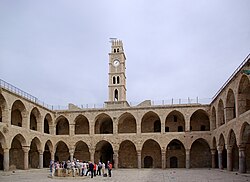
In Acre, the Hospitaller fortress and the 18th-century Khan al-Umdan (the region's largest caravanserai) highlight the intersection of medieval military power and Ottoman trade.
Frequently Asked Questions
Why was the region renamed Syria Palaestina by the Romans?
The Romans renamed the province from Judaea to Syria Palaestina after the Bar Kokhba revolt (132–135 CE) as a means of "de-judaizing" the area following the rebellion.
What was the demographic makeup of the region in the mid-19th century?
Around 1850, the population was approximately 350,000 people, consisting of roughly 85% Muslims, 11% Christians, and 4% Jews.
What is the significance of the Green Line?
The Green Line refers to the borders between Israel and the Palestinian territories (the West Bank and Gaza Strip), largely following the armistice lines.
Who currently administers the Gaza Strip?
While the Palestinian National Authority is the de jure administrator, the Gaza Strip is de facto controlled by Hamas.
What is a caravanserai, and is there an example in Palestine?
A caravanserai is a roadside inn where travelers could rest and recover from the day's journey. The Khan al-Umdan in Acre, built in 1784, is the largest and best-preserved example in the region.