Oztoticpac Lands Map: A Window into Aztec Land Ownership and Colonial Transition
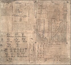
The Oztoticpac Lands Map is a rare and intricate pictorial Aztec codex that offers a detailed glimpse into the socio-economic landscape of 16th-century Mexico. Created around 1540 on amatl (native paper), this document serves as both a legal record and a geographical survey of lands in Texcoco. Today, it is preserved by the Library of Congress and featured in the permanent exhibition "Exploring the Early Americas."
Measuring 76 cm by 84 cm, the map utilizes a combination of pictorial imagery and alphabetic text written in Nahuatl, the primary language of the Aztec Empire. The document is rendered in red and black ink, blending traditional indigenous artistic styles with the administrative needs of the early colonial era.
Key Facts
- Origin: Texcoco, created approximately between 1540 and 1544.
- Material: Native amatl paper.
- Current Location: Library of Congress, Washington D.C.
- Primary Subject: Land ownership and litigation involving Don Carlos Ometochtzin Chichimecatecotl.
- Unique Feature: Detailed depictions of grafted European and local fruit trees.
- Related Works: Linked to the Humboldt Fragment VI in the Staatsbibliothek of Berlin.
Legal Conflict and Historical Context
The map is deeply intertwined with the tragic history of Don Carlos Ometochtzin Chichimecatecotl, the son of Nezahualpilli. The glosses on the map suggest the land was originally granted to Don Carlos by the Texcocan lord Ixtlilxochitl I. However, the document's creation was likely driven by legal disputes over ownership.
In 1539, Don Carlos was tried and executed by Bishop Juan de Zumárraga using inquisitorial powers. Following his death, Antonio Pimentel Tlahuilotzin, the governor of Texcoco, likely commissioned the map between 1540 and 1544 as part of a strategic effort to reclaim the lands previously held by Don Carlos.
Cadastral Details and Land Management
The Oztoticpac Lands Map functions as a cadastral—a map showing the boundaries and ownership of land parcels. It depicts a palace held by Don Carlos in Oztoticpac and outlines 75 specific pieces of land.
The map provides a granular look at colonial agriculture, showing:
- Nahua families who farmed the plots.
- Toponymic glyphs (symbols representing place names) to identify specific properties.
- Rent records, indicated by standard glyphic representations for tenants.
- Precise measurements of the plots, though these have sparked academic debate.
The Challenge of Measurement
Scholars have struggled to translate the Nahua glyphs for units of measure into modern metrics. While researcher Cline developed a chart of units, he remained cautious about exact calculations. In 1991, H.R. Harvey proposed that the map utilized two different units of measurement, applying his expertise in Aztec arithmetic to resolve the discrepancy. This ongoing study of paleography (the study of ancient writing systems) continues to refine our understanding of the map's scale.
Horticulture and the Columbian Exchange
One of the most significant aspects of the map is its depiction of fruit trees. This serves as a visual record of the Columbian Exchange—the widespread transfer of plants, animals, and culture between the Americas and the Old World.
The map illustrates both local and European species, including:
- Pears, apples, and peaches.
- Quince and pomegranates.
- Grapevines.
Crucially, the map shows that these trees were grafted—a horticultural technique used to improve plant health and increase crop yield. This indicates that European plants were not just imported but were actively integrated into sophisticated local farming practices to increase property value. The economic importance of these trees is further evidenced by a lawsuit filed by Pedro de Vergara against the Holy Office of the Inquisition regarding trees owned by the late Don Carlos.
| Feature | Details |
|---|---|
| Dimensions | 76 cm × 84 cm |
| Language | Nahuatl (Pictorial and Alphabetic) |
| Key Figures | Don Carlos Ometochtzin, Ixtlilxochitl I, Bishop Juan de Zumárraga |
| Land Parcels | 75 pieces of land |
| Botanical Focus | Grafted European and local fruit trees |
Frequently Asked Questions
What is the Oztoticpac Lands Map?
It is a 16th-century Aztec codex from Texcoco that serves as a pictorial and written record of land ownership, measurements, and agricultural assets, currently held by the Library of Congress.
Why was the map created?
It was likely commissioned by Governor Antonio Pimentel Tlahuilotzin between 1540 and 1544 to help reclaim lands that had belonged to Don Carlos Ometochtzin after his execution by the Inquisition.
What does the map reveal about early colonial farming?
The map shows the integration of European fruit trees (like peaches and pomegranates) into local horticulture and demonstrates the use of grafting to increase agricultural productivity.
How do scholars determine the size of the land plots?
Scholars analyze Nahua glyphs for units of measure. While challenging, researchers like H.R. Harvey have used Aztec arithmetic to argue that two different units of measurement were used in the map.
Where can the map be viewed today?
The physical map is part of the "Exploring the Early Americas" exhibition at the Library of Congress, and high-resolution digital enlargements are available on their website.