Oroño Boulevard: The Historic Heart of Rosario
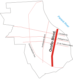
Located in the center-east of Rosario, Santa Fe Province, Oroño Boulevard (Bulevar Oroño) stands as one of the city's most distinguished thoroughfares. This two-way boulevard runs north-south, stretching from the coastal avenue along the Paraná River to the southern edge of the urbanized area. Along with the river and Pellegrini Avenue, it serves as the unofficial boundary for the city's downtown district.
A Legacy of Urban Beauty
The boulevard was inaugurated in 1868 under the original name Bulevar Santafesino. Its creation was part of a beautification program launched by the municipality, which had been established six years prior. At the time of its opening, Rosario was a growing city of approximately 23,000 residents. This urban development plan also included the opening of Pellegrini Avenue, known then as Bulevar Argentino.
Originally spanning 18 blocks, the boulevard quickly became the preferred location for the city's wealthiest families to construct grand mansions. In 1904, the street was renamed to honor Nicasio Oroño, a former Intendant of Rosario and governor of Santa Fe, following his death.
Architectural and Urban Design
Today, the downtown segment of the boulevard is renowned for its historical architecture. Many of the original mansions still stand, though some have been repurposed into institutional buildings, including private hospitals and schools.
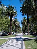
The layout of the boulevard is characterized by a contrast between its transit lanes and its leisure spaces. While the vehicle lanes are comparatively narrow, the central reservation—the strip of land separating the opposing lanes of traffic—is wide and lush. This area is lined with palm trees and features a tiled pedestrian walkway and a dedicated cycleway for cyclists.
Summary of Oroño Boulevard
| Feature | Details |
|---|---|
| Location | Rosario, Santa Fe Province, Argentina |
| Original Name | Bulevar Santafesino (est. 1868) |
| Current Name Origin | Nicasio Oroño (renamed 1904) |
| Key Landmarks | Historical mansions, schools, and private hospitals |
| Infrastructure | Two-way lanes, central reservation with palm trees, cycleway |
Key Facts
- Established: 1868 as part of a municipal beautification effort.
- Geography: Runs north-south from the Paraná River to the southern urban limit.
- Naming: Renamed in 1904 after Nicasio Oroño, former governor of Santa Fe.
- Urban Role: Marks the unofficial limit of downtown Rosario.
- Design: Features a wide central reservation with a cycleway and pedestrian tiles.
Frequently Asked Questions
What was the original name of Oroño Boulevard?
The boulevard was originally inaugurated in 1868 as Bulevar Santafesino.
Who was Nicasio Oroño?
Nicasio Oroño was a former Intendant of Rosario and the governor of Santa Fe; the boulevard was renamed in his honor in 1904.
What can be found in the central reservation of the boulevard?
The wide central reservation is lined with palm trees and includes a cycleway and a tiled area for pedestrians.
What types of buildings are located along the downtown segment?
The area hosts several historical mansions formerly owned by wealthy families, some of which now serve as private hospitals or schools.
Where is Oroño Boulevard located in relation to the city?
It is located in the center-east of Rosario, running north-south from the Paraná River coastal avenue to the southern limit of the urbanized area.