Offshore Site Investigation
Offshore site investigations are critical processes used to evaluate the seabed before the installation of marine structures. Similar to onshore geotechnical investigations, these studies ensure that the underwater environment can support the intended engineering loads. The process is typically divided into three distinct phases: a desk study, geophysical surveys, and geotechnical surveys.
Key Facts
- Three-Phase Approach: Investigations progress from data compilation (desk study) to remote sensing (geophysical) and physical sampling (geotechnical).
- Ground Truthing: Geotechnical surveys are used to verify and "ground truth" the data collected during geophysical surveys.
- Penetration Depth: Shallow surveys cover the first few meters below the mudline, while deep surveys can reach several hundred meters.
- In Situ Testing: Tools like the Cone Penetrometer (CPT) measure soil strength directly on the seabed to avoid sample disturbance.
Phase 1: The Desk Study
The desk study is the foundational phase, often spanning several months depending on the project's scale. During this time, engineers gather existing information from scientific literature, journal articles, conference proceedings, and various databases. The primary goal is to evaluate risks, assess design options, and plan the subsequent field phases.
Key data sought during this phase include bathymetry (the measurement of depth in oceans or lakes), regional geology, potential geohazards, seabed obstacles, and metocean data (meteorological and oceanographic conditions).
Phase 2: Geophysical Surveys
Geophysical surveys utilize remote sensing to map the seafloor and analyze the layers beneath it. These surveys are essential for producing images of the seabed to identify irregularities, lateral variability, ice gouges, or specific objects. They are also used to locate materials like gravel and sand deposits for the construction of artificial islands.
To analyze sub-bottom stratigraphy—the layering of soil and rock beneath the seabed—specialized tools such as boomers, sparkers, pingers, and chirp are employed. These surveys are conducted from research vessels equipped with sonar devices, including single-beam and multibeam echosounders, side-scan sonars, "towfish," and remotely operated vehicles (ROVs).
Generally, geophysical surveys precede geotechnical work, although they may be interwoven in larger projects.
Phase 3: Geotechnical Surveys
Geotechnical surveys provide a detailed account of soil engineering properties and seabed stratigraphy. These surveys combine sampling, drilling, and in situ testing, with laboratory analysis conducted both offshore and onshore. Depending on the water depth and metocean conditions, these operations are carried out from specialized vessels such as geotechnical drillships, semi-submersibles, jackup rigs, or large hovercraft.
To maintain a constant position over a specific location, vessels use dynamic positioning or four-point anchoring systems.
Shallow vs. Deep Penetration
Shallow penetration surveys focus on the first few meters below the mudline. They are often sufficient for light structures or for planning subsea pipeline routes and may be conducted simultaneously with shallow geophysical surveys.
Deep penetration surveys are required for larger structures, collecting data from depths reaching several hundred meters below the mudline. These deep drill holes require the drilling unit to remain in a precise position for several days.
Sampling and Drilling Techniques
Surface sampling is performed using grab samplers or box corers. A box corer is particularly valuable because it provides undisturbed specimens used to determine water content, relative density, and mechanical properties.
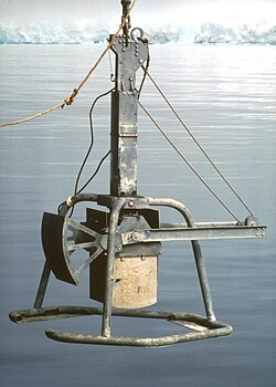
Other sampling methods include tube corers, which may be gravity-driven, piston-driven, or vibration-driven (known as a vibrocorer). For deeper exploration, drilling is used to record stratigraphy or rock formations. This process uses a drill string of 5-inch (13 cm) diameter pipes with a dragbit assembly. Viscous drilling mud is pumped down the pipe to carry soil cuttings back to the surface. Specialized tools like "Shelby tubes," "piston samplers," and "split spoon samplers" are used to extract soil from these drill holes.
In Situ Soil Testing
Testing soil in situ (in its original place) is advantageous because it eliminates the disturbance caused by relocating samples to a laboratory. Two primary instruments are used for this purpose:
- Cone Penetrometer (CPT): A rod with a cone-shaped tip (typically 60 degrees) is pushed into the soil. The resistance to penetration indicates soil strength, while a sleeve measures frictional resistance. Some models can also measure pore water pressure.
- Shear Vane: Used for soft to medium cohesive soils, this tool consists of four plates welded at 90-degree angles. As the rod is rotated at a constant rate, the torque resistance is measured to determine the undrained shear strength and residual strength.
| Phase | Primary Goal | Key Tools/Methods | Typical Output |
|---|---|---|---|
| Desk Study | Risk assessment & planning | Literature review, databases | Initial risk profile, design options |
| Geophysical Survey | Seafloor mapping & stratigraphy | Sonar, ROVs, Boomers, Chirp | Bathymetry maps, sub-bottom profiles |
| Geotechnical Survey | Engineering properties & ground truthing | CPT, Box corers, Drilling, Shear vane | Soil strength, undisturbed samples |
Frequently Asked Questions
What is the difference between geophysical and geotechnical surveys?
Geophysical surveys use remote sensing (like sonar and seismic tools) to create images of the seabed and its layers without physical contact. Geotechnical surveys involve physical sampling and testing of the soil to determine its actual engineering properties.
Why is in situ testing preferred over laboratory testing in some cases?
In situ testing, such as the CPT or shear vane test, is preferred because it measures the soil in its natural state. This avoids the "disturbance" that occurs when soil is extracted and transported, which can alter its mechanical properties.
What is a box corer and why is it used?
A box corer is a sampling device used to extract undisturbed specimens from the seabed surface. These undisturbed samples are critical for accurately determining the soil's relative density and water content.
How do vessels stay in one place during deep drilling?
Vessels use either dynamic positioning systems (computer-controlled thrusters) or mooring systems with four-point anchoring to maintain a constant position over the drill site.
What is the purpose of drilling mud in offshore investigations?
Viscous drilling mud is pumped down the drillpipe to collect soil cuttings produced by the drillbit and carry them back up to the surface for analysis.