Nimbostratus Clouds: The Science of Steady Precipitation
When the sky turns a uniform, dark grey and a steady rain or snow begins to fall for hours or even days, you are likely experiencing the effects of a nimbostratus cloud. Unlike the dramatic, towering clouds associated with thunderstorms, nimbostratus clouds are amorphous, layered masses that blanket the sky, bringing consistent precipitation over vast areas.
The name is derived from the Latin word nimbus, meaning "rain bearing cloud," and stratus, referring to its layered structure. While they often appear as low-level clouds to an observer on the ground, they are actually multilevel systems that can span a significant portion of the troposphere.
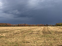
Key Facts
- Altitude: Typically ranges from 500 to 5,500 meters (2,000 to 18,000 ft).
- Appearance: A dark, featureless, and opaque layer of water vapor.
- Precipitation: Produces continuous rain, snow, or ice pellets; occasionally produces virga (precipitation that evaporates before hitting the ground).
- Weather Association: Primarily linked to warm fronts and occluded fronts.
- Distinction: Unlike cumulonimbus clouds, nimbostratus do not produce lightning or thunder on their own.
Formation and Atmospheric Dynamics
Nimbostratus clouds typically form along a warm front or an occluded front. This occurs when a warm air mass rises slowly over a cooler one, creating a thick layer of clouds. Often, this process begins with higher-level clouds like cirrostratus and altostratus; as the altostratus thickens and descends to lower altitudes, it transforms into nimbostratus.
While they are non-convective (meaning they don't have the strong upward currents found in storm clouds), they can have a vertical extent similar to large cumulus clouds, though their horizontal expanse is usually much greater.
Embedded Thunderstorms
Although nimbostratus clouds themselves do not produce thunder, they can occasionally hide other cloud types. In unstable conditions—such as those found along the east coast of Australia—cumulonimbus clouds can become embedded within the nimbostratus layer. These "embedded thunderstorms" can produce intense downpours and lightning, though the overarching grey blanket of the nimbostratus makes it difficult to distinguish the storm cells from the ground.
Visual Characteristics and Subtypes
To a surface observer, the base of a nimbostratus cloud is diffuse and generally dark, though it may occasionally appear illuminated from within. Because they are so thick and featureless, they are not subdivided into species or varieties.
However, they are often accompanied by pannus. Pannus are accessory clouds that form as ragged, shredded layers of cloud fragments within the precipitation below the main cloud deck.
| Feature | Details |
|---|---|
| Abbreviation | Ns |
| Genus | Nimbostratus |
| Typical Altitude | 500–5,500 m |
| Precipitation Types | Rain, snow, ice pellets, virga |
| Frontal Association | Warm and Occluded fronts |
| SYNOP Code | C M 2 |
Comparison with Other Cloud Types
Nimbostratus is part of the stratiform family, meaning it is sheet-like and non-convective. It differs from other stratiform clouds primarily by its ability to produce significant precipitation and its multi-level vertical reach.
- Stratus: Low-level clouds (up to 2,000 m) that are thinner and produce less precipitation.
- Altostratus: Middle-level clouds (2,000 m to approx. 7,000 m) that often precede nimbostratus.
- Cirrostratus: High-level clouds composed of ice crystals, often creating halos around the sun.
- Cumulonimbus: Vertical, convective clouds that produce intense rain and thunderstorms, unlike the steady rain of nimbostratus.
Historical Classification
The systematic study of these clouds began with Luke Howard in 1802, who established the categories of cirriform, cumuliform, and stratiform. Howard originally used the term nimbus to describe a complex blend of these forms capable of producing significant rain. In the 20th century, the International Meteorological Committee refined this definition, reclassifying it as a stratiform cloud and renaming it nimbostratus in the 1932 International Atlas of Clouds.
Frequently Asked Questions
What is the difference between nimbostratus and cumulonimbus?
Nimbostratus clouds produce steady, moderate precipitation over a wide area without thunder or lightning. Cumulonimbus clouds are towering vertical clouds that produce intense, short-lived downpours, lightning, and thunder.
What is nimbostratus pannus?
Pannus are ragged, accessory cloud fragments that form in the precipitation zone beneath the main nimbostratus cloud base.
Can nimbostratus clouds produce snow?
Yes, nimbostratus clouds are responsible for continuous precipitation, which can manifest as rain, snow, or ice pellets depending on the temperature.
What does it mean when nimbostratus is described as having virga?
Virga occurs when precipitation falls from the nimbostratus cloud but evaporates or sublimates before it ever reaches the ground.
How do nimbostratus clouds affect weather forecasting?
The appearance of nimbostratus is generally a sign of an approaching warm or occluded front, indicating that steady precipitation may last for several days depending on the speed of the weather system.