New Orleans Hurricane of 1915: A Category 4 Catastrophe
In late September 1915, a powerful tropical cyclone tore through the Caribbean and the Gulf of Mexico, eventually striking the coast of Louisiana. Known as the New Orleans Hurricane of 1915, this storm stands as the most intense tropical cyclone of the 1915 Atlantic hurricane season. With devastating winds and a record-breaking storm surge, it left a lasting mark on the region's history and infrastructure.
The storm's journey from a weak tropical system to a major Category 4 hurricane illustrates the volatile nature of Atlantic weather patterns. Its impact on New Orleans and surrounding parishes serves as a historical benchmark for storm intensity in the Gulf Coast region.
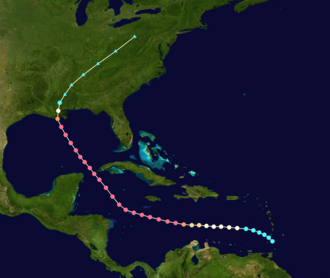
Key Facts
- Peak Intensity: Category 4 major hurricane with maximum sustained winds of 145 mph (233 km/h).
- Landfall: Struck near Grand Isle, Louisiana, on September 29, 1915, as a strong Category 3 storm.
- Human Toll: Estimated 275 to 279 fatalities.
- Financial Loss: Approximately $13 million (1915 USD).
- Lowest Pressure: 931 mbar (hPa), recorded by a ship observation.
- Rainfall Record: Franklin, Louisiana, recorded 14.43 inches of rain.
Meteorological History
Formation and Intensification
The system began as a weak tropical storm moving across the southern Windward Islands on September 21, 1915. It gradually strengthened as it tracked westward across the Caribbean Sea, reaching hurricane intensity by September 23. By September 24, it had evolved into a major hurricane.
On September 25, the storm reached its peak intensity. A ship observation documented a minimum central pressure of 931 mbar (hPa), and maximum sustained winds crested at 145 mph (233 km/h). Using the modern Saffir-Simpson scale—a system used to classify hurricanes based on their sustained wind speed—this would be rated as a powerful Category 4 hurricane.
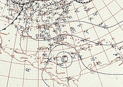
Path to Landfall
After passing south of Jamaica and moving through the Yucatán Channel, the hurricane entered the Gulf of Mexico on September 28. As it approached the Louisiana coast, it moved over shallower continental shelf waters, which caused slight weakening. It made landfall near Grand Isle at 18:00 UTC on September 29.
At the time of landfall, the storm was a strong Category 3 hurricane with estimated winds of 125 mph (201 km/h). A reading at Tulane University recorded a central pressure of 952 mbar, which was the lowest pressure ever recorded in the United States at that time. Reanalysis suggests the actual pressure at landfall may have been as low as 944 mbar.
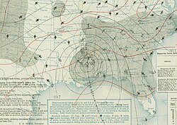
Dissipation
The hurricane maintained its strength longer than usual due to the moist swampland of the Louisiana Acadiana region. However, land interaction eventually caused rapid weakening. Within twelve hours, it degraded to a tropical storm. By September 30, it transitioned into an extratropical cyclone over Mississippi and moved northeastward, finally dissipating over Pennsylvania on October 1.
Preparations and Warnings
The U.S. Weather Bureau issued storm warnings for the Eastern Seaboard starting September 27. By the morning of September 28, warnings were sent to the Louisiana coast via telegraph and mail. A specific hurricane warning for the Gulf coast from Pensacola, Florida, to New Orleans was issued that afternoon.
Local authorities in New Orleans enforced strict curfews as the storm approached. Meteorologist Isaac Cline later noted that the effective dissemination of these warnings and the enforcement of the curfew were critical in mitigating the loss of life within the city.
Impacts and Destruction
Caribbean and Gulf Effects
In the Caribbean, the storm caused strong gales in Kingston, Jamaica, which severed telecommunications between the capital and outlying districts. This disruption contributed to a spike in yearly cotton prices. In the Gulf of Mexico, the storm produced rough surf that damaged several vessels, including the cutter Miami.
Devastation in Louisiana
The most severe impacts occurred along the Louisiana coast. A record-setting storm surge, estimated between 15 and 20 feet (4.6 to 6.1 m), inundated low-lying lands south of New Orleans and areas adjacent to Lake Pontchartrain. Levee failures in Carrollton left some areas submerged under 8 feet of water for four days.
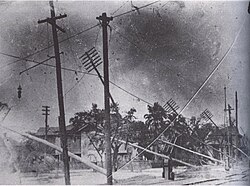
In New Orleans, wind gusts reached 130 mph (210 km/h). The destruction was widespread: the French Market was partially demolished, and the roof of a prominent Masonic temple collapsed. The landmark First Presbyterian Church on Lafayette Square and St. Anna's Episcopal Church were both destroyed.
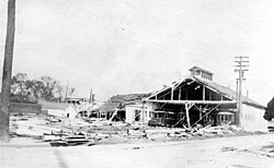
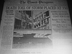
The storm also crippled the city's infrastructure. Over 8,000 telephones were put out of commission, and the city's power station failed, disabling electric lighting. In the Port of New Orleans, four small steamers and several coal barges sank. Total damage to public and private property in the city was estimated at $5 million, with an additional $1.75 million in shipping losses.
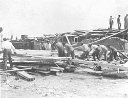
![First Presbyterian Church on Lafayette Square, destroyed by the great hurricane of 1915, collapsing at 5:02pm.[18]](/images/45/f7/45f707c4d57e2b9d9dce6391c93abe1b8735e6d49b268c30ceb8ba101e6a789b.jpg)
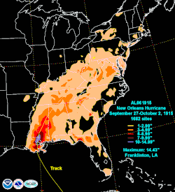
Outside the city, the destruction was even more absolute. In Leeville, only one house remained standing, and 100 homes were demolished between Golden Meadow and Cut Off. In Franklin, the storm dropped 14.43 inches of rain, setting a 24-hour September rainfall record.
Regional Effects
While Mississippi experienced some flooding in Biloxi, and Alabama saw rainfall and suspended train services, Mobile, Alabama, avoided significant damage as winds remained below 50 mph.
Storm Summary
| Metric | Detail |
|---|---|
| Peak Wind Speed | 145 mph (233 km/h) |
| Lowest Pressure | 931 mbar (hPa) |
| Landfall Category | Category 3 |
| Fatalities | 275 – 279 |
| Total Damage | $13 million (1915 USD) |
| Max Rainfall | 14.43 in (Franklin, LA) |
Frequently Asked Questions
What was the peak intensity of the 1915 New Orleans Hurricane?
The hurricane reached a peak intensity of Category 4, with maximum sustained winds of 145 mph (233 km/h) and a minimum central pressure of 931 mbar.
How many people died as a result of the storm?
It is estimated that between 275 and 279 people lost their lives due to the hurricane.
What was the most significant impact on the city of New Orleans?
The city suffered from extreme wind gusts of up to 130 mph and a massive storm surge that overtopped levees, causing significant flooding in western New Orleans and the destruction of landmarks like the First Presbyterian Church.
How did the 1915 storm compare to other Louisiana hurricanes?
While not as deadly as the 1893 Chenier Caminanda hurricane, it remained the deadliest Louisiana hurricane until Hurricane Betsy struck 50 years later in 1965.
What record was set during this hurricane?
The storm produced a storm surge of 15 to 20 feet, which set a record for the highest tide reported in the region at that time.