Murujuga Cultural Landscape
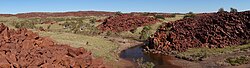
The Murujuga Cultural Landscape represents one of the most significant archaeological treasures on Earth. Located on the Burrup Peninsula and surrounding islands, this site hosts the world's largest and most important collection of petroglyphs—rock carvings etched into ancient stone. With some carvings dated back more than 45,000 years, Murujuga provides an unparalleled window into the lives, beliefs, and environments of Australia's First Nations people over tens of millennia.
The landscape is characterized by its vast array of standing stones and engravings, numbering over one million. These artworks frequently depict animals, including the now-extinct thylacine (Tasmanian tiger). Beyond the art, the region contains approximately 2,500 archaeological sites, including campsites, shell middens (ancient refuse heaps of shells and food remains), and quarries.
Key Facts
- World Heritage Status: Inscribed in 2025 as Australia's 21st World Heritage site.
- Scale: Over one million petroglyphs across the peninsula and islands.
- Age: Some carvings are estimated to be between 40,000 and 50,000 years old.
- Geology: Art is etched into 2.7 billion-year-old igneous rocks.
- Protected Area: The World Heritage designation covers 99.881 hectares.
The Science of the Stone
The rock art of Murujuga is a result of a specific geological process. The carvings were created by etching away the outer millimetres of red-brown iron oxide, which exposed a pale, centimetre-thick layer of weathered clay. Beneath this layer lies an incredibly hard, dark grey-green igneous rock composed of granophyre, gabbo, dolerite, and granite.
Industrial Conflict and Conservation
The preservation of Murujuga has been a point of intense conflict since the 1960s, as the region's rich cultural value clashed with its potential for industrial development. Between 1963 and 2006, estimates suggest that between 4% and 24.4% of the rock art on the Burrup Peninsula was destroyed to make way for industry.
In 1996, a land use plan attempted to balance these interests by dividing the region into a Conservation, Heritage and Recreation Area (62% of the Burrup) and an Industrial Area (38%).
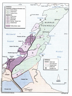
Environmental concerns have remained central to the debate. In 2002, evidence emerged that acidic emissions from nearby industry were causing irreparable harm to the rock art. Acidic dust combines with water to form acids that dissolve manganese and iron compounds, leading to the fragmentation of the rock varnish and patina (the thin surface layer of the rock).
The Road to Recognition
The campaign for protection gained momentum through the National Trust of Australia and the World Monuments Fund, which listed the Dampier Rock Art Precinct as one of the 100 Most Threatened Monuments in the world in 2003. After years of advocacy and political negotiation, 90% of the remaining rock art areas of the Dampier Archipelago were placed on the National Heritage List in 2008.
Scientific Controversy and World Heritage Listing
The path to UNESCO recognition was marked by scientific debate. The Murujuga Rock Art Monitoring Program, a collaboration between the Murujuga Aboriginal Corporation, Curtin University, and the WA Department of Water and Environmental Regulation, studied the impact of emissions over five years.
A 2025 report summary claimed air quality was "good" to "very good" and found no evidence of acid rain. However, this summary was met with fierce criticism from experts. Professor Ben Smith and Emeritus Professor Adrian Baddeley alleged that the executive summary twisted the findings of the full 800-page report and removed critical early warning thresholds for pollution to favor industrial expansion.
Despite these controversies, the site was officially designated a World Heritage Site in July 2025 during the 47th session of the World Heritage Committee in Paris. It was recognized under three criteria: as a masterpiece of human creative genius, as an exceptional testimony to a living or disappeared civilization, and as an outstanding example of traditional human interaction with the environment.
| Feature | Details |
|---|---|
| UNESCO Inscription Year | 2025 |
| Total Petroglyphs | Over 1,000,000 |
| Estimated Age | 40,000 to 50,000+ years |
| World Heritage Area | 99.881 ha |
| Key Geological Composition | Granophyre, Gabbo, Dolerite, Granite |
Visiting Murujuga
Public access to the site is managed through the Murujuga National Park. In August 2020, the Ngajarli Trail was opened to the public. This 700-metre universal boardwalk was created in collaboration between Traditional Owners and the government, featuring interpretative signs to help visitors understand the deep cultural significance of the landscape.
Frequently Asked Questions
What are petroglyphs?
Petroglyphs are images created by removing part of a rock surface by incising, picking, carving, or abrading, as opposed to painting on the rock.
How old is the rock art at Murujuga?
Some of the Aboriginal rock carvings have been dated to more than 45,000 years old, with much of the collection estimated to be between 40,000 and 50,000 years old.
What animals are depicted in the carvings?
Many of the engravings depict images of the thylacine, also known as the Tasmanian tiger, which is now extinct.
Why is the site considered threatened?
The site has faced threats from industrial land clearance for roads and pipelines, as well as chemical damage from acidic industrial emissions that fragment the rock's surface.
Who are the Traditional Owners of the area?
The Ngarluma Yindjibarndi Foundation Ltd (NYFL) and the Murujuga Aboriginal Corporation (MAC) represent the Traditional Owners in various land use and industrial agreements.