Mississippi River Trail
The Mississippi River Trail (MRT) is a massive designated bicycle and pedestrian corridor that mirrors the winding path of the Mississippi River. Spanning approximately 3,000 miles (4,800 km), this epic route connects the river's headwaters in the north to its mouth in the south, offering travelers a diverse experience of the American landscape.
The trail begins at Lake Itasca in Minnesota and concludes near Venice, Louisiana. While some portions of the route utilize dedicated multi-use trails—paths designed for various non-motorized users—much of the journey follows paved roadways shared with motor vehicles.
Key Facts
- Total Length: Approximately 3,000 miles (4,800 km).
- Termini: Starts at Itasca State Park, MN; ends in Venice, LA.
- Surface: Primarily paved.
- Designation: Part of the U.S. Bicycle Route System (USBR 45 in Minnesota).
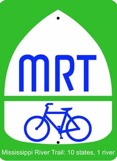
- Route Markers: Green background with a white triangle and bicycle symbol, labeled "MRT".
Designation and Signage
The MRT uses a specific route marker based on a 2012 Federal Highway Administration (FHWA) design. This marker features a green background, a white triangle, and a bicycle symbol, but replaces numeric route codes with the abbreviation "MRT".
In 2013, the Minnesota segment was officially designated as U.S. Bicycle Route 45 (USBR 45). While long-term plans aim to extend the USBR 45 designation to the rest of the trail—and concurrently designate the southernmost section near New Orleans as USBR 51—local partners in Minnesota initially opted to keep the MRT shield to maintain brand consistency and save costs.
Route Description
The trail is conceptually divided into Northern, Central, and Southern sections. In several regions, the trail is mirrored, with routes existing on both the eastern and western banks of the river.
The Northern Section
The journey begins at Itasca State Park in Minnesota, which offers over 20 miles of paved biking trails. From there, the MRT winds through county roads to Bemidji, where it connects to the 100-mile Paul Bunyan Trail, a rail-trail conversion (a former railroad line converted into a recreational path) leading to Brainerd.
As the trail moves south through Little Falls and St. Cloud, it enters the urban environment of the Twin Cities (Minneapolis and St. Paul). Here, cyclists pass through the Mississippi National River and Recreation Area, visiting landmarks such as St. Anthony Falls, Minnehaha Falls Regional Park, and Fort Snelling State Park. In Minneapolis, the route incorporates the Minnehaha Trail and the Grand Rounds National Scenic Byway trails.
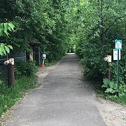
Continuing south, the trail passes through Wabasha and Winona before entering Wisconsin at Prescott. The Wisconsin segment primarily follows the Great River Road north of Prairie du Chien and various state and county highways to the south.
On the western bank, the Iowa section covers roughly 328 miles. It enters near Lansing and passes through Dubuque and the Iowa Quad Cities (Buffalo, Davenport, and Bettendorf), where paved off-road paths and riverfront greenways are common. The route continues through Muscatine and Burlington, eventually reaching the Missouri state line via Fort Madison and Keokuk.
The Central Section
In Illinois, the trail runs from the Wisconsin border near Galena down to Cairo. It traverses cities such as Moline, Rock Island, Nauvoo, and Quincy, and passes near the Cahokia Mounds State Historical Site. The route intersects the American Discovery Trail twice—once in the north near Rock Island and again in the south near East St. Louis.
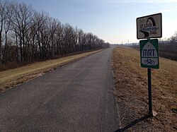
In Missouri, the route is highlighted by the 12-mile St. Louis Riverfront Trail, which runs from the Chain of Rocks Bridge south along the levee past the Gateway Arch.
The Southern Section
The Tennessee portion of the trail is highly detailed, entering Obion County and passing through the Reelfoot National Wildlife Refuge and Reelfoot Lake State Park. The route navigates a complex series of local roads through Lake, Dyer, Lauderdale, and Tipton counties, crossing the Hatchie River and following the ridges of the Chickasaw Bluffs.
Upon entering Shelby County, the trail passes through Meeman-Shelby Forest State Park and enters Memphis. In the city, the route follows Whitney Avenue, passes the Pyramid Arena, and utilizes the Riverwalk Trail system in Downtown Memphis. The trail concludes its Tennessee leg by crossing the Mississippi River via the Memphis-Arkansas Bridge or the Harahan Bridge.
Route Summary Table
| Region | Key Landmarks / Cities | Notable Trail Features |
|---|---|---|
| Northern | Lake Itasca, Twin Cities, Dubuque | Paul Bunyan Rail-Trail, Grand Rounds Byway |
| Central | St. Louis, Galena, Cairo | St. Louis Riverfront Trail, Cahokia Mounds |
| Southern | Memphis, Reelfoot Lake | Chickasaw Bluffs, Riverwalk Trail system |
Frequently Asked Questions
Is the Mississippi River Trail entirely off-road?
No. While some segments utilize dedicated multi-use trails and riverfront greenways, a significant portion of the 3,000-mile route follows paved roadways used by motor vehicles.
Where does the trail officially begin and end?
The trail begins at the headwaters of the Mississippi River in Itasca State Park, Minnesota, and ends near the mouth of the river in Venice, Louisiana.
What is the difference between the MRT and USBR 45?
The MRT is the general name for the trail. USBR 45 is the official designation within the U.S. Bicycle Route System. Currently, the Minnesota section is officially designated as USBR 45, though there are plans to extend this designation further south.
What is a rail-trail conversion?
A rail-trail is a former railroad corridor that has been converted into a recreational path for pedestrians and cyclists, such as the Paul Bunyan Trail in Minnesota.
Which states does the Mississippi River Trail pass through?
The trail traverses several U.S. states, including Minnesota, Wisconsin, Iowa, Illinois, Missouri, Kentucky, Tennessee, Arkansas, and Louisiana.