Metairie, Louisiana
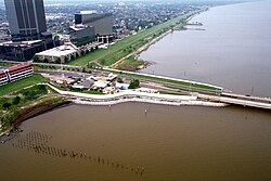
Metairie is a prominent unincorporated community and census-designated place (CDP) located within Jefferson Parish, Louisiana. As a vital part of the New Orleans metropolitan area, it stands as the largest community in Jefferson Parish and ranks as the fifth-largest CDP in the United States. With a population of 143,507 as of the 2020 census, Metairie's scale is such that, if it were incorporated, it would be the fourth-largest city in Louisiana, trailing only behind Shreveport.
Key Facts
- Population: 143,507 (2020 Census).
- Status: Unincorporated census-designated place (CDP).
- Location: Eastern Jefferson Parish, bordering New Orleans and Kenner.
- Geography: Total area of 23.30 square miles, primarily land.
- Climate: Humid subtropical with hot, humid summers and mild winters.
- Key Landmark: Southern terminus of the Lake Pontchartrain Causeway.
History and Evolution
The name "Métairie" is derived from the French term for a small tenant farm where farmers paid landlords with a share of their produce, a system known as sharecropping (or métayage). This agricultural practice defined the community from the 1760s until urbanization began in the 1910s.
European settlement began in the 1720s with French settlers in an area then called Tchoupitoulas. This region is characterized by the Metairie Ridge, a natural levee created by Bayou Metairie, an ancient branch of the Mississippi River. The Acolapissa Native Americans originally used this ridge as a road, making it the oldest road in the New Orleans area. The introduction of an electric streetcar in the late 1910s spurred significant development, leading to the creation of upscale housing tracts in the 1920s, now known as "Old Metairie."
Environmental Challenges
Metairie has faced several significant weather events over the decades. The 1947 Fort Lauderdale hurricane brought 125 mph winds and left much of the community under six feet of water. In 1965, Category 3 Hurricane Betsy caused extensive wind damage and moderate flooding. More recently, the May 8, 1995 Louisiana flood dropped over 20 inches of rain in twelve hours, while Hurricane Katrina in 2005 triggered a migration of residents from Orleans Parish to Metairie to replace destroyed housing.
Geography and Climate
Metairie is situated in eastern Jefferson Parish. It is bounded by New Orleans to the east (separated by the 17th Street Canal), Kenner to the west, Lake Pontchartrain to the north, and the Illinois Central Railroad tracks to the south. The community covers approximately 23.2 square miles of land and a small fraction of water (0.04 square miles).
The region experiences a humid subtropical climate. This is characterized by hot, humid summers and short, mild winters. Metairie receives an average of 62.5 inches of annual precipitation, with the heaviest rainfall occurring in summer and the driest period in October.
| Metric | Value |
|---|---|
| Total Area | 23.30 sq mi |
| Elevation | 3 ft (0.91 m) |
| Average Annual Precipitation | 62.5 in (1,590 mm) |
| Typical Summer Highs | 90°F (32°C) or greater |
| Driest Month | October |
Demographics and Society
The population of Metairie has fluctuated over the last fifty years, growing from 136,477 in 1970 to 143,507 in 2020. The community is ethnically diverse; as of the 2020 census, the makeup included 62.89% non-Hispanic white, 18.42% Hispanic or Latino, 10.98% Black or African American, and 3.73% Asian residents.
Economically, the 2019 American Community Survey reported a median household income of $60,404 and a median owner-occupied housing value of $246,600. The population is predominantly Catholic, reflecting the Spanish and French colonial history of the region, though it also hosts diverse faith communities, including Reform and Orthodox Jewish congregations.
Infrastructure, Education, and Culture
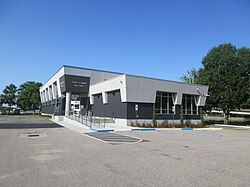
Metairie serves as a commercial hub for the region, with Veterans Memorial Boulevard and the central business district on Causeway Boulevard acting as primary economic centers. Transportation is supported by Interstate 10, the Earhart Expressway, and mass transit provided by Jefferson Transit.
Education and Public Services
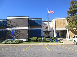
Public education is managed by the Jefferson Parish Public School System. While East Jefferson High School is the primary zoned public high school within the community, students are also zoned to schools in Kenner and Jefferson. The area also features several private institutions, including Archbishop Chapelle and Archbishop Rummel High Schools.
Sports and Recreation
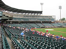
Metairie has a rich sports history, having hosted the New Orleans Baby Cakes Triple-A baseball team from 1993 to 2019. Currently, the New Orleans Gold of Major League Rugby play their home games at the Gold Mine on Airline.
Frequently Asked Questions
What does the name Metairie mean?
Metairie comes from the French word for a small tenant farm where the farmer paid the landlord with a share of the produce, a practice known as sharecropping.
Is Metairie an incorporated city?
No, Metairie is an unincorporated community and is classified as a census-designated place (CDP) within Jefferson Parish.
What is the tallest building in Metairie?
Three Lakeway Center is the tallest building in Metairie, standing at 403 feet (123 m), making it the tallest building in Louisiana outside of New Orleans and Baton Rouge.
How does the climate in Metairie compare to New Orleans?
Metairie shares a similar humid subtropical climate with New Orleans, featuring hot, humid summers, mild winters, and significant annual rainfall averaging 62.5 inches.
Which major transportation routes serve Metairie?
Major routes include Interstate 10, Veterans Memorial Boulevard, and the Earhart Expressway, as well as the southern terminus of the Lake Pontchartrain Causeway.