Mejillones: A Strategic Port City in Chile's Atacama Desert
Located on the northern side of the Mejillones Peninsula, Mejillones is a vital port city and commune within the Antofagasta Province of Chile's Antofagasta Region. Positioned between the vast Pacific Ocean to the west and the Atacama Desert—the most arid desert on Earth—to the east, this city marks the widest point of Chile's territory along a parallel, spanning 362 km.
The city's name is derived from the Spanish word mejillón, meaning "mussel," a reference to the abundant shellfish that served as a primary food source for the area's indigenous inhabitants.
Key Facts
- Location: Antofagasta Region, Chile (23°06′S 70°27′W).
- Population: 14,084 inhabitants (2024).
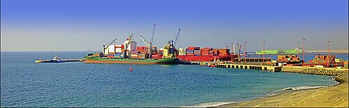
- Economic Impact: Its eight terminals handle 7.1% of Chile's annual external trade tonnage (2024).
- Geography: Situated at an elevation of 5 meters, bordering the Atacama Desert.
- Demographics: Approximately 29.8% of the population are immigrants, primarily from South America.
Historical Evolution
Early Settlements and Guano Mining
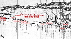
The human history of Mejillones began with the Chango people, who inhabited the coastal region starting around 1825. While the area appeared on maps of the Captaincy General of Chile in the 18th century, its industrial potential was realized in the 1830s. Between 1838 and 1839, French businessmen known as the "Brothers Latrille" contracted Juan López (a miner known as Chango Lopez) to extract guano—seabird droppings used as fertilizer—from deposits south of the city.
By 1841, mining operations expanded around San Luciano hill. The Bolivian government granted a concession to Domingo Latrille, leading to massive shipments of guano to Europe between 1841 and 1842.
Border Disputes and the War of the Pacific
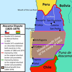
In 1845, Bolivian President Manuel Isidoro Belzu established a small fort to transform Mejillones into a Bolivian port. The territory remained a point of contention between Chile and Bolivia until the Boundary Treaty of 1866. To manage interests, both nations co-financed the Offices of Administration and Security of Customs to regulate mineral exports and protect workers.
The region became a focal point during the War of the Pacific (1879-1883). On October 8, 1879, the Battle of Angamos took place off the peninsula, resulting in the Chilean capture of the Peruvian monitor Huáscar.
Urban Development and Modernization
Following the war, the nitrate industry boomed, utilizing the Antofagasta railroad to transport minerals through Mejillones. After severe waves damaged existing shipping facilities, the city was rebuilt under Chilean sovereignty. In 1906, naval engineer Emilio de Vitds designed a realistic urban plan consisting of 63 city blocks, officially established by President Germán Riesco on February 7, 1906.
Economy and Environmental Challenges
Today, Mejillones is a powerhouse of Chilean trade, with its port terminals playing a critical role in the nation's external commerce. However, this industrialization has come at a cost. The city is located within a sacrifice zone—an area heavily impacted by industrial pollution. As of 2024, the area hosts eight coal-fired power stations, which have contributed to seabed pollution and a subsequent decline in local fishing.
Demographics and Administration
Mejillones is administered as a commune by a municipal council and an elected mayor (alcalde). The population has seen steady growth since the early 20th century, reaching 14,084 by 2024. The population is nearly evenly split between males (49.9%) and females (50.1%), with a high urban concentration of 96.8%.
| Year | Population | Annual Growth Rate (±%) |
|---|---|---|
| 1907 | 4,096 | — |
| 1952 | 3,599 | +2.05% |
| 2002 | 8,418 | +2.92% |
| 2024 | 14,084 | +0.64% |
Frequently Asked Questions
What is the origin of the name Mejillones?
The name is the plural of the Spanish word for "mussel," referring to the abundance of these shellfish which were a staple food for the indigenous Chango people.
What is the significance of the Battle of Angamos?
Fought on October 8, 1879, during the War of the Pacific, this naval battle took place off the peninsula and ended with the Chilean navy capturing the Peruvian monitor Huáscar.
How important is the port of Mejillones to Chile?
The port is highly significant, with its eight terminals accounting for 7.1% of Chile's total annual external trade tonnage as of 2024.
What environmental issues does the city face?
Mejillones is considered a sacrifice zone due to the presence of eight coal-fired power stations, which have caused seabed pollution and negatively impacted the local fishing industry.
Who are the primary immigrant groups in Mejillones?
Immigrants make up 29.8% of the population, with the vast majority (29.5%) originating from South America.