May 1995 Louisiana Flood: A Historic Rainfall Event
In May 1995, a catastrophic weather event struck the region stretching from the New Orleans metropolitan area into southern Mississippi. Known as the May 1995 Southeast Louisiana and Southern Mississippi Flood, this disaster was characterized by extreme rainfall that overwhelmed local infrastructure and caused unprecedented damage. Between May 8 and May 10, the region experienced a relentless deluge that remains one of the most significant rain-driven floods in the area's history.
Key Facts
- Maximum Rainfall: 27.5 inches (700 mm) recorded near Necaise, Mississippi.
- Human Toll: Six fatalities recorded.
- Financial Impact: Over $3.1 billion in total damages.
- Property Damage: Approximately 56,000 homes damaged across 12 parishes.
- Duration: A 40-hour event consisting of two distinct waves of heavy rain.
Meteorological Synopsis
The disaster was driven by a complex interaction of atmospheric conditions. A cold front approached from the west, preceded by a squall line. As this front moved, it encountered a tropical airmass across east Louisiana and southeast Mississippi. By May 9, the front dissipated near Baton Rouge, but its remains acted as a focusing axis for heavy precipitation, supported by an upper-level trough.
Simultaneously, warm, moist air flowed continually from the Gulf of Mexico. The highest rainfall totals were linked to a theta-e ridge (a region of high equivalent potential temperature) at the 850 mb pressure surface, stretching from the Gulf into the Mississippi River Delta.
A critical factor in the severity of the flood was the occurrence of training thunderstorms. This meteorological phenomenon occurs when multiple thunderstorms form and move over the same area in succession, like cars of a train, leading to extreme rainfall accumulation in localized spots.
In New Orleans, the city's pumping stations—which were only rated to handle a maximum of 1 inch (25 mm) of rain per hour—were completely overwhelmed. They could not move water into Lake Pontchartrain as quickly as the storms delivered it.
Timeline of the Disaster
May 7 to May 8: The First Wave
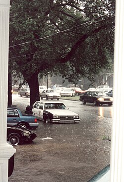
Heavy rainfall began around 5:30 p.m. on May 7 south of Lake Pontchartrain. By the early morning of May 8, flooding had already begun in Orleans and Jefferson Parishes, impacting New Orleans, Metairie, Kenner, River Ridge, and Harahan.
May 9: Expansion to the Northshore
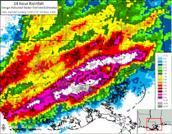
By the evening of May 9, the focus of the rainfall shifted north of Lake Pontchartrain into Saint Tammany Parish, affecting Slidell, Covington, Mandeville, and Abita Springs. Simultaneously, heavy rains hit south Mississippi, particularly in Harrison, Hancock, and Pearl River Counties, including Gulfport and Bay St. Louis.
May 10: Peak Flooding and River Records
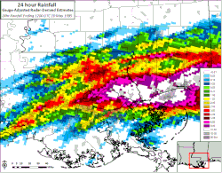
The event concluded on the morning of May 10. Severe river flooding impacted the Jourdan, Tchoutacabouffa, and Wolf Rivers in Mississippi. Each of these rivers reached new record stages at the time, though the Wolf River record was later surpassed during Hurricane Isaac in 2012.
Rainfall Analysis
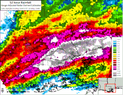
The rainfall totals were staggering, with 10 to 20 inches common across much of the impacted region. The first wave hit the southshore of Lake Pontchartrain hardest, while the second wave targeted the northshore and coastal Mississippi.
Many locations experienced rainfall amounts that exceeded the 100-year average recurrence interval (a 1% chance of being exceeded in any given year). The peak recording near Necaise, Mississippi, reached 27.5 inches, an event estimated to have only a 0.1% annual probability, or a 1,000-year recurrence interval.
| Location | Rainfall (Inches) | Rainfall (Millimeters) |
|---|---|---|
| Necaise, MS | 27.50" | 698 mm |
| Abita Springs, LA | 24.46" | 621 mm |
| New Orleans (Tulane University), LA | 24.05" | 611 mm |
| New Orleans (Lakefront Airport), LA | 15.44" | 392 mm |
| Slidell, LA | 19.09" | 485 mm |
| New Orleans (International Airport), LA | 9.67" | 246 mm |
Impact and Aftermath
The May 1995 event was more extensive and costly than the Louisiana floods of November 1979 and 1989 combined. For the city of New Orleans, it represented the worst flooding between Hurricane Betsy (1965) and Hurricane Katrina (2005), and remains the most severe flood in the city's history caused by rainfall alone.
The financial toll was immense. New Orleans suffered $360 million in damages, while the broader region's losses exceeded $3 billion. In Jefferson Parish alone, 14,600 homes and apartments were flooded, and thousands of vehicles were destroyed.
In response, the region undertook significant infrastructure upgrades. New pumping stations were constructed and canals were expanded. Specific improvements were made to the underground canals beneath Claiborne and Napoleon Avenues in Broadmoor, as well as drainage projects in Hollygrove connected to the 17th St. Canal.
Frequently Asked Questions
What caused the extreme rainfall in May 1995?
The flooding was caused by a cold front interacting with a tropical airmass, supported by an upper-level trough and a constant supply of moist air from the Gulf of Mexico. This created "training" thunderstorms that repeatedly hit the same areas.
How did this flood compare to other New Orleans disasters?
It was the most severe rainfall-only flood recorded in New Orleans. In terms of overall impact, it was the worst flooding the city faced between Hurricane Betsy in 1965 and Hurricane Katrina in 2005.
Why were the pumping stations unable to prevent the flooding?
The pumping stations at the time were only rated to handle a maximum of 1 inch of rain per hour. The intensity of the storms far exceeded this capacity, meaning water accumulated faster than it could be pumped into Lake Pontchartrain.
Which location recorded the highest rainfall?
The highest rainfall was recorded near Necaise, Mississippi, with a total of 27.5 inches (700 mm), an event with an estimated 1,000-year recurrence interval.
What infrastructure changes were made after the flood?
The city expanded canals and built new pumping stations. Key improvements were made to the drainage systems in Hollygrove and the underground canals under Napoleon and Claiborne Avenues in the Broadmoor neighborhood.