Market Street: The Evolution of San Francisco's Main Artery
Market Street is more than just a thoroughfare; it is the central spine of San Francisco. Stretching three miles from the waterfront to the foothills of Twin Peaks, this iconic street has served as a transition point between competing urban grids, a victim of natural disaster, and a laboratory for modern urban planning. From its origins as a surveyed line in a Mexican trading post to its current transformation into a transit-first corridor, Market Street reflects the growth and resilience of the city itself.
The Birth of a Dividing Line
The story of Market Street begins in 1839 in the Mexican trading post of Yerba Buena. The first street grid was laid by Jean Jacques Vioget, featuring blocks of 412 by 275 feet aligned with cardinal directions. After the United States captured the settlement during the Mexican–American War, it was renamed San Francisco in 1847.
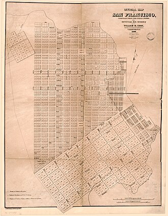
In that same year, 26-year-old civil engineer Jasper O'Farrell surveyed the land and laid out Market Street. He envisioned the street as an arrow pointing directly toward "Los Pechos de la Chola" (the Breasts of the Maiden), known today as Twin Peaks. However, O'Farrell faced significant pushback from property owners. They insisted he maintain Vioget's north-south grid in the north and establish a separate, diagonally-offset grid for Happy Valley (south of Market) aligned with Mission Street, featuring larger 600-by-400-foot blocks.
Market Street was designed as the transition between these two conflicting grids. O'Farrell established it as the widest street in town at 120 feet. This decision nearly cost him his life; outraged landowners, fearing the width encroached on their property, attempted to lynch him, forcing O'Farrell to flee to Sausalito and eventually Sonoma for safety.
Conquering the Dunes
Early Market Street was not the paved boulevard seen today. It was obstructed by massive sand dunes, including one 60-foot dune where the Palace Hotel now stands and another nearly 90 feet tall further west. Between 1852 and 1873, these dunes were leveled first by James Cunningham and later by David "Steam Paddy" Hewes. Hewes utilized a powerful steam shovel—nicknamed "Steam Paddy" because it could do the work of a dozen men—to clear the land.
The effort was monumental: up to 2,500 short tons of sand were moved daily, clearing roughly 5,000 acres. This displaced sand was repurposed to fill Yerba Buena Cove, Mission Bay, and to assist in the construction of the San Francisco and San Jose Railroad.
Growth and the "Roar of the Four"
As the city grew, Market Street became a hub for commerce and transit. David Hewes used his steam shovel operations to lay tracks from Market to Beale to transport sand. By July 4, 1860, the Market Street Railroad Company launched the city's first horsecar-powered railway line.
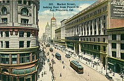
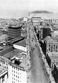
By 1918, the street experienced a period of intense transit competition. The San Francisco Municipal Railway (Muni) and the United Railroads of San Francisco both operated pairs of rail tracks along the thoroughfare. This four-track system became known as the "roar of the four," with Union Railroad tracks on the inside and Muni tracks on the outside.
Catastrophe and Artistic Rebirth
The 1906 San Francisco earthquake and subsequent fires devastated the corridor. Buildings from the waterfront to Dolores and Franklin streets were ruined or dynamited to stop the flames. Despite the destruction, the recovery was swift; track repairs began as early as April 22, 1906.
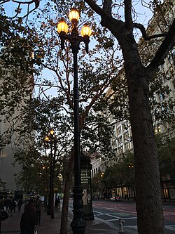
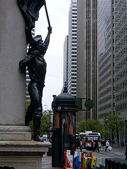
During the rebuilding process, the city sought to balance utility with aesthetics. In 1908, Willis Polk designed the Path of Gold Street Lamps to make the necessary but unsightly overhead trolley wires more acceptable to the public. These ornamental poles featured tops designed by Leo Lentelli and Walter D'Arcy Ryan, with bases by Arthur Putnam depicting covered wagons, mountain lions, and prospectors.
Modernization and the Subway Era
The mid-20th century brought a shift toward subterranean transit. Following the 1962 creation of the Bay Area Rapid Transit (BART) district, the San Francisco Planning and Urban Renewal Association (SPUR) published "What to Do About Market Street," aiming to revitalize the area as a business and entertainment center. Landscape architect Lawrence Halprin proposed that the street be divided into five districts, each with a distinctive character.
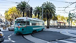
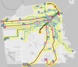
Construction of the Market Street subway began in July 1967, moving Muni streetcars underground as the Muni Metro. While this modernized transit, the prolonged construction contributed to the economic decline of the mid-Market shopping district. In the 1980s, the popularity of Historic Trolley Festivals led to the reinstatement of surface tracks via the F Market historic streetcar line.
The Shift Toward a Car-Free Future
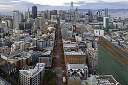
In the 21st century, the focus shifted from moving cars to moving people. Starting in 2009, the city began traffic-calming trials, restricting eastbound private automobiles. These changes eventually became permanent, and by 2015, private vehicles were banned from turning onto Market Street between Third and Eighth streets.
The Better Market Street project, initiated under Mayor Gavin Newsom and continued by Mayors Ed Lee and London Breed, represents the most ambitious redesign in the street's history. The plan, approved in October 2019, involves a total reconfiguration of the corridor to prioritize pedestrians, cyclists, and transit users. Key features include:
- Sidewalk-level bicycle lanes to improve safety.
- Dual boarding islands: inside islands for rapid service and outside islands for local service.
- Infrastructure upgrades, including new sewer and utility lines and full repaving.
The transition to a largely car-free Market Street began on January 29, 2020. Early data indicated that transit travel times improved by 6% to 12% with minimal impact on surrounding traffic.
Market Street Summary
| Era/Event | Key Development | Impact |
|---|---|---|
| 1847 Survey | Jasper O'Farrell's layout | Created a transition between two competing street grids. |
| 1852–1873 | Dune leveling via "Steam Paddy" | Cleared 5,000 acres of sand to make the street viable. |
| 1906 | Earthquake and Fire | Widespread destruction followed by rapid rebuilding. |
| 1967–1982 | Subway Construction | Transitioned Muni to Muni Metro; created BART access. |
| 2020 | Car-Free Transition | Prioritized transit and pedestrians; reduced travel times. |
Key Facts
- Length: Approximately 3 miles (4.8 km) from the waterfront to Twin Peaks.
- Original Width: 120 feet (37 m), which was considered excessive by early landowners.
- The "Roar of the Four": A period when four sets of rail tracks (two Muni, two Union Railroad) ran simultaneously.
- Sand Removal: Up to 2,500 short tons of sand were moved daily during the leveling process.
- Modern Cost: The full Better Market Street project is expected to cost at least $500 million.
Frequently Asked Questions
Why is Market Street diagonal compared to other streets?
Market Street was designed by Jasper O'Farrell to serve as a transition between two different street grids: the north-south grid of Yerba Buena and the diagonally-offset grid of Happy Valley aligned with Mission Street.
What are the Path of Gold street lamps?
These are highly ornamental light poles designed in 1908 to make the overhead trolley wires more aesthetically pleasing. They feature historical sculptures of covered wagons, mountain lions, and prospectors.
How did the 1906 earthquake affect Market Street?
The earthquake and subsequent fires destroyed many buildings from the waterfront to Dolores and Franklin streets. Some buildings were even dynamited to create firebreaks, though track repairs began within days.
What is the "Better Market Street" project?
It is a comprehensive redesign aimed at improving transportation for pedestrians, cyclists, and transit riders. It includes sidewalk-level bike lanes, reconfigured boarding islands, and the removal of most private automobile traffic.
What happened to the surface streetcars?
Most surface operations were moved underground to the Muni Metro between 1980 and 1982. However, the F Market historic streetcar line was later reinstated due to the popularity of trolley festivals.