Madeira River: The Amazon's Most Powerful Tributary
The Madeira River (Portuguese: Rio Madeira, meaning "wood river") is a vital artery of the South American continent. As the largest tributary of the Amazon River, it contributes approximately 15% of the entire basin's water volume. Historically known by the indigenous name Cuyari, this massive waterway serves as a critical corridor for biodiversity, indigenous cultures, and international trade between Bolivia and Brazil.
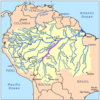
Key Facts
- Length: Approximately 1,450 km (900 mi), extending up to 3,250 km (2,020 mi) when measured as the Madeira-Mamoré system.
- Basin Size: 1,376,000 square kilometers (531,000 sq mi).
- Average Discharge: 31,200 cubic meters per second near its mouth.
- Primary Role: The Amazon's largest tributary, providing a significant portion of its water flow.
- Key Cities: Porto Velho, Humaitá, Manicoré, Borba, Novo Aripuanã, and Nova Olinda do Norte.
Geography and Course
The Madeira River begins at the confluence of the Madre de Dios and Mamoré rivers near Guayaramerín, Bolivia. From its source, it flows northward, acting as a natural border between Bolivia and Brazil until it reaches the Abunã River. At this point, the river shifts direction toward the northeast, cutting through the Brazilian state of Rondônia before eventually merging with the Amazon River.
The river's catchment area is immense, covering roughly 850,000 square kilometers—an area nearly equal to the combined size of France and Spain. This basin collects drainage from the northeastern slopes of the Andes and the southwestern slopes of Mato Grosso. The landscape is characterized by the Mojos and Beni plains, where vast areas (approximately 90,000 sq km) are flooded annually to an average depth of one meter for several months.
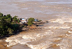
Historically, the section between the border and Porto Velho was non-navigable due to significant drops in the riverbed, most notably the Teotônio and San Antônio falls. These rapids once featured flow rates and drops exceeding those of the Boyoma Falls in Africa, though they are now submerged by the Santo Antônio Dam reservoir.
Hydrology and Climate
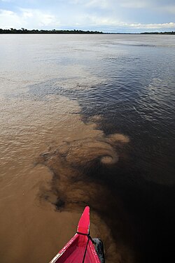
The Madeira is a whitewater river, a term used to describe rivers that are turbid due to high sediment loads carried from the Andes. However, its tributaries vary; some are clearwater (such as the Aripuanã and Ji-Paraná) and others are blackwater (such as the Manicoré).
Rainfall in the basin is highly variable, ranging from 75 cm to 300 cm annually, with extremes reaching up to 700 cm. This precipitation fuels a massive discharge system. Even at its upper reaches, the river's mean annual discharge is 18,000 cubic meters per second—roughly half that of the Congo River—increasing to 31,200 cubic meters per second as it approaches the Amazon.
Navigation and Economic Importance
The Madeira is one of the most active waterways in the Amazon basin. During the rainy season, the river level can rise by more than 15 meters (50 ft), allowing ocean-going vessels to travel as far as the San Antonio falls near Porto Velho. In contrast, the dry season (June to November) limits navigation to craft with a draft of about 2 meters.
The river is a cornerstone of regional logistics, facilitating the export of nearly four million tons of grains—primarily soy and corn—from Porto Velho to international markets via the ports of Itacoatiara and Santarem. It also serves as a fuel pipeline, transporting gasoline from the REMAN refinery in Manaus to the states of Acre, Rondônia, and Mato Grosso.
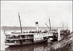
The Madeira-Mamoré Railroad
To bypass the unnavigable rapids, the Madeira-Mamoré Railroad was constructed as a 365 km loop to Guajará-Mirim. While currently non-functional, it historically bridged the gap between the Atlantic shipping routes and the upper river system.
Ecology and Biodiversity
The Madeira River basin is one of the most species-rich freshwater systems on Earth, with over 900 identified fish species. It is the exclusive habitat of the Bolivian river dolphin, which is considered by some scientists as a distinct species from the Amazon river dolphin.
Conservation efforts include the Rio Madeira Sustainable Development Reserve, established in 2006. This reserve covers 283,117 hectares along the north bank, protecting the region's unique biodiversity and the marshy Ilha Tupinambaranas at the river's mouth.
Hydroelectric Development and Controversy
The Brazilian government has implemented two major run-of-the-river hydroelectric projects: the Santo Antônio Dam and the Jirau Dam. Unlike traditional dams, these do not create massive reservoirs, and both include fish ladders to mitigate environmental impact.
Despite these measures, the projects remain controversial. Environmentalists and organizations like the Worldwatch Institute have raised concerns regarding the potential extinction of migratory fish if fish ladders fail, as well as increased pressure on indigenous territories and accelerated deforestation.
Summary of River Characteristics
| Feature | Detail |
|---|---|
| Source | Confluence of Madre de Dios and Mamoré (Bolivia) |
| Mouth | Amazon River (Brazil) |
| Length | 1,450 km (Main stem) / 3,250 km (Madeira-Mamoré) |
| Water Type | Whitewater (Turbid/Sediment-rich) |
| Max Discharge | 52,804 m³/s |
| Key Infrastructure | Santo Antônio and Jirau Dams |
Frequently Asked Questions
What does the name "Madeira" mean?
The name is Portuguese for "wood river," reflecting the characteristics of the waterway.
Why is the Madeira River considered a "whitewater" river?
It is classified as whitewater because it carries a high volume of sediment from the Andes mountains, giving the water a turbid, opaque appearance.
How does the river affect regional trade?
The river is a primary transport route for millions of tons of soy and corn, as well as refined fuel from Manaus to the interior states of Brazil.
What is the significance of the Bolivian river dolphin?
The Bolivian river dolphin is a rare species (or subspecies) that is restricted specifically to the upper Madeira River system, making the area critical for its survival.
What are the environmental concerns regarding the Madeira dams?
The primary concerns include the potential failure of fish ladders leading to the extinction of migratory fish, as well as the social and environmental pressures placed on indigenous lands and forests.