Longitude: The Science and History of East-West Positioning
Longitude is a geographic coordinate used to specify the east-west position of a point on the surface of the Earth or another celestial body. Expressed as an angular measurement in degrees and denoted by the Greek letter lambda (λ), it allows us to pinpoint any location on a global scale. While latitude measures north-south positioning, longitude relies on a system of meridians—imaginary semicircular lines that run from pole to pole.
By international convention, the 0° longitude line is the Prime Meridian, which passes near the Royal Observatory in Greenwich, London. Locations east of this line are assigned positive longitudes, while those to the west are negative.
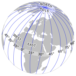
Key Facts
- Prime Meridian: The 0° reference line located in Greenwich, UK.
- Time Correlation: Every 15° of longitude corresponds to a one-hour difference in local time.
- Measurement: Longitude is measured in degrees, minutes, and seconds.
- Variable Length: Unlike latitude, the physical length of one degree of longitude shrinks as you move from the equator toward the poles.
- The Chronometer: John Harrison's invention solved the critical problem of determining longitude at sea.
The Relationship Between Longitude and Time
Because the Earth rotates, longitude is inextricably linked to time. A difference of 15° in longitude results in a one-hour difference in local time relative to the Sun. Consequently, determining longitude requires comparing local time with an absolute time reference from a known location.
Historically, this absolute time was obtained through celestial events, such as lunar eclipses, or later via telegraph and radio signals. While the principle is simple, creating a reliable method to measure this time difference took centuries of scientific effort.
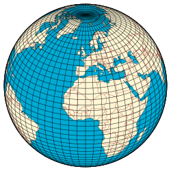
The Evolution of Longitude Determination
Early Astronomical Attempts
During the later Middle Ages, scholars used astronomical tables to estimate longitude. In 1178, a lunar eclipse was used to find the longitude differences between Toledo, Marseilles, and Hereford. Later, Christopher Columbus attempted to use lunar eclipses during his second and fourth voyages, though his results contained significant errors, ranging from 13° to 38° W.
The Quest for the Marine Chronometer
The difficulty of navigation led the British Parliament to pass the Longitude Act of 1714, offering rewards for a method to determine longitude within 1° and 0.5°. Two primary solutions emerged: lunar distances (calculating the angle between the Moon and a star) and the marine chronometer.
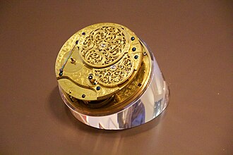
John Harrison, a carpenter and clock-maker, spent over three decades developing five chronometers that could keep accurate time at sea. Although lunar distances became practical after 1790 via the Nautical Almanac, chronometers eventually replaced them by 1850 because they simplified both observation and calculation.
The Impact of Telecommunications
The invention of the telegraph in the 1830s and 1840s allowed for the near-instant transmission of time signals. The United States Coast and Geodetic Survey used this technology between 1874 and 1890 to accurately map regions across the Americas, Japan, and China. By the early 20th century, wireless telegraphy (radio) enabled ships to receive time signals from stations like the Eiffel Tower, allowing navigators to synchronize their chronometers while underway.
Technical Measurements and Values
Longitude is typically expressed in sexagesimal notation (degrees, minutes, and seconds). For example, a coordinate might be written as 23° 27′ 30″ E. For higher precision, decimal fractions are used (e.g., 23.45833° E). In scientific calculations, these angular measures are often converted to radians.
The Physical Length of a Degree
The physical distance of one degree of longitude varies based on the latitude (φ). At the equator, one degree is approximately 111.320 km. As you move toward the poles, the circles of latitude shrink, and the distance of a degree of longitude decreases until it reaches 0 km at the poles. In contrast, the length of a degree of latitude remains relatively constant, increasing by only about 1% from the equator to the pole.
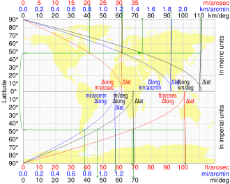
| Latitude (φ) | Δ Latitude (km) | Δ Longitude (km) |
|---|---|---|
| 0° | 110.574 | 111.320 |
| 15° | 110.649 | 107.551 |
| 30° | 110.852 | 96.486 |
| 45° | 111.133 | 78.847 |
| 60° | 111.412 | 55.800 |
| 75° | 111.618 | 28.902 |
| 90° | 111.694 | 0.000 |
Frequently Asked Questions
What is the difference between longitude and latitude?
Longitude measures the east-west position of a point relative to the Prime Meridian, while latitude measures the north-south position relative to the equatorial plane.
Why does the length of a degree of longitude change?
Because meridians converge at the poles, the distance between them decreases as you move away from the equator. At the poles, the distance between any two meridians is zero.
How did John Harrison contribute to navigation?
Harrison developed the marine chronometer, a highly accurate clock that could maintain the time of a reference meridian (like Greenwich) despite the motion and temperature changes of a ship at sea, allowing for the precise calculation of longitude.
What is a geographical mile?
A geographical mile is defined as the length of one minute of arc along the equator, which is approximately 1.855 km or 1.153 miles.
How is longitude related to time zones?
The Earth rotates 360° in 24 hours, which means it rotates 15° every hour. This is why time zones are generally based on 15° increments of longitude.