Latitude: The Science of Geographic Positioning
In the field of geography, latitude is a critical coordinate used to specify the north-south position of a point on the surface of the Earth or any other celestial body. Measured as an angle, latitude ranges from 0° at the Equator to 90° at the North Pole and −90° at the South Pole. When paired with longitude, it creates a precise coordinate system that allows us to pinpoint any location on the globe.
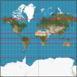
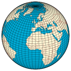
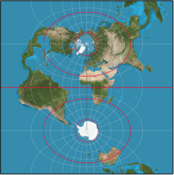
Lines of constant latitude, known as parallels, run east-west and remain parallel to the equator. Together with meridians (lines of constant longitude), they form a grid known as a graticule.
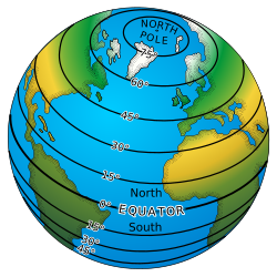
Key Facts
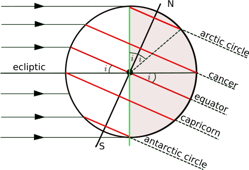
- Range: Latitude spans from -90° (South Pole) to +90° (North Pole).
- Reference Point: The Equator serves as the 0° baseline.
- Earth's Shape: While often modeled as a sphere, Earth is more accurately an oblate ellipsoid (flattened at the poles).
- Standard System: WGS84 is the reference ellipsoid used by the Global Positioning System (GPS).
- Measurement: Latitude is typically denoted by the Greek letter phi (φ).
Foundational Concepts of Geographic Modeling
To define latitude accurately, scientists use different levels of abstraction to model the Earth's irregular surface:
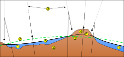
- The Geoid: This is a model of the physical surface that approximates mean sea level across oceans and continues under land masses.
- The Reference Surface: Because the geoid is complex, it is approximated by simpler mathematical shapes. While a sphere is the simplest, an ellipsoid of revolution provides a much more accurate fit.
The latitude of a physical point on Earth is determined by finding the corresponding point on the reference surface along a line normal (perpendicular) to that surface.
Latitude on a Spherical Model
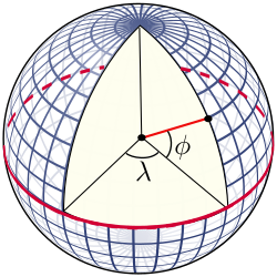
In a simplified spherical model, the graticule is constructed relative to the Earth's rotation axis. The points where this axis intersects the surface are the poles. The Equator is a great circle formed by a plane perpendicular to the rotation axis passing through the center of the sphere.
On a sphere, the latitude of a point is the angle between the equatorial plane and the radial vector (the normal to the surface) at that point.
Meridian Distance on a Sphere
Using a mean Earth radius (R) of 6,371 km, the length of one degree of latitude is approximately 111.2 km (69.1 statute miles). This breaks down further into:
- One minute of latitude: 1.853 km (1.00 nautical mile).
- One second of latitude: 30.8 meters (101 feet).
The Ellipsoid Model and Geodesy
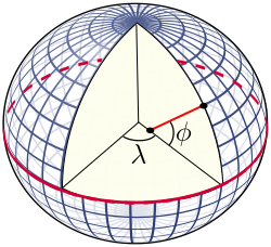
As proven by Isaac Newton in 1687, a rotating fluid body in equilibrium forms an oblate ellipsoid—a sphere compressed along its axis of rotation. This means the Earth's polar radius is shorter than its equatorial radius.

Modern geodesy relies on reference ellipsoids. Before satellites, these were localized to specific survey areas. Today, GPS uses the WGS84 (World Geodetic System 1984), a geocentric ellipsoid centered on the Earth's center of mass.
WGS84 Specifications
The WGS84 ellipsoid is defined by its semi-major axis (equatorial radius) and inverse flattening:
- Equatorial Radius (a): 6,378,137.0 m
- Inverse Flattening (1/f): 298.257223563
- Polar Radius (b): 6,356,752.31425 m
The difference between the equatorial and polar radii is approximately 21 km (13 miles). While this seems significant, it is small enough that the Earth looks nearly spherical to the naked eye.
Geodetic vs. Geocentric Latitude
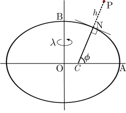
Because the Earth is not a perfect sphere, the "normal" line to the surface does not always pass through the center of the Earth. This leads to two different definitions of latitude:
- Geodetic Latitude (φ): The angle between the equatorial plane and the line normal to the ellipsoid surface. This is the standard latitude used in mapping and GPS.
- Geocentric Latitude (θ): The angle between the equatorial plane and a line connecting the point directly to the center of the Earth.
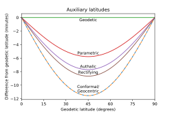
These two values are identical at the poles and the equator but differ by up to 11.5 minutes of arc at approximately 45° latitude.
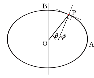
Auxiliary Latitudes
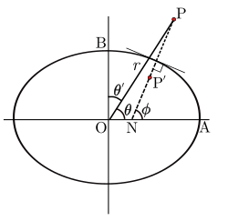
Depending on the mathematical application—such as map projections—different "auxiliary" latitudes are used:
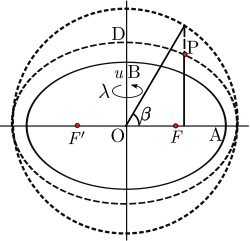
- Parametric (Reduced) Latitude (β): Used to parameterize Cartesian coordinates on the ellipsoid.
- Rectifying Latitude (μ): Scales meridian distance so the pole is 90°, essential for the Transverse Mercator projection.
- Authalic Latitude (ξ): Used for area-preserving (equal-area) projections.
- Conformal Latitude (χ): Used in the Mercator projection to preserve angles.
- Isometric Latitude (ψ): Used in normal and Transverse Mercator projections to create a mesh of squares on the ellipsoid.
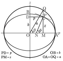
Comparison of Latitude Types
The following table illustrates how different latitude definitions deviate from the standard geodetic latitude (φ) on the WGS84 ellipsoid.
| Geodetic (φ) | Parametric (β - φ) | Authalic (ξ - φ) | Rectifying (μ - φ) | Conformal (χ - φ) | Geocentric (θ - φ) |
|---|---|---|---|---|---|
| 0° | 0.00′ | 0.00′ | 0.00′ | 0.00′ | 0.00′ |
| 15° | −2.88′ | −3.84′ | −4.32′ | −5.76′ | −5.76′ |
| 30° | −5.00′ | −6.66′ | −7.49′ | −9.98′ | −9.98′ |
| 45° | −5.77′ | −7.70′ | −8.66′ | −11.54′ | −11.55′ |
| 60° | −5.00′ | −6.67′ | −7.51′ | −10.01′ | −10.02′ |
| 75° | −2.89′ | −3.86′ | −4.34′ | −5.78′ | −5.79′ |
| 90° | 0.00′ | 0.00′ | 0.00′ | 0.00′ | 0.00′ |
Frequently Asked Questions
What is the difference between geodetic and geocentric latitude?
Geodetic latitude is measured based on a line perpendicular to the surface of the Earth's ellipsoid, while geocentric latitude is measured based on a line connecting the surface point directly to the Earth's center. They differ most at mid-latitudes (around 45°).
Why is WGS84 important for GPS?
WGS84 provides a standardized mathematical model (an oblate ellipsoid) of the Earth's shape. Because latitude and longitude are defined relative to a specific ellipsoid, GPS needs a universal datum to ensure coordinates are consistent worldwide.
How does the Earth's shape affect latitude measurements?
Because the Earth is an oblate ellipsoid rather than a perfect sphere, the distance of one degree of latitude varies slightly depending on where you are. This is why high-precision geodesy requires ellipsoidal models rather than spherical ones.
What are parallels in geography?
Parallels are imaginary lines that run east-west, parallel to the Equator. Every point on a specific parallel shares the same latitude.
What is the geoid?
The geoid is a model of the Earth's surface that represents the mean sea level, accounting for variations in gravity. It is the physical surface that mathematical ellipsoids attempt to approximate.